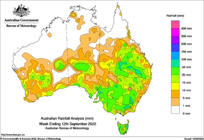
STORMS moved across much of inland eastern Australia, as a cold front tapped into moist tropical air and resulted in heavy rain, hail and flash flooding.
Queensland’s Maranoa and Warrego District received 50-80 millimetres from storms in the 24 hours to 9am on September 9, with several sites setting September daily rainfall records.
 Weekly totals of 25-50mm fell in many inland areas of southern Queensland and New South Wales, elevating the level of flood risk across the region particularly in southern Queensland.
Higher weekly totals of up to 90mm from storms fell in the Maranoa and Warrego districts in Queensland, in alpine areas, and in north-east Tasmania.
The highest weekly total at a Bureau gauge was 91.6mm at Tasmania’s Mount Barrow, and the highest daily total was 85mm at Palmerston, Qld, to 9am on September 9.
A cold front brought weekly totals of 5-25mm across southern WA, while a weak low brought similar amounts to the east coast of Australia.
Rain on already wet catchments saw a continuation in flooding summarised as follows:
Tasmania: Moderate flooding of South Esk River; minor flooding of North Esk River;
Victoria: Moderate flooding of Kiewa River, minor flooding of north-eastern rivers and the Avoca River;
NSW: Major flooding of Lachlan River; Moderate flooding of Bogan and Darling Rivers; moderate flooding of Murray River at Barham possible by mid September, minor flooding of western inland rivers;
Queensland: Moderate flood warnings for the Balonne, Paroo and Bulloo Rivers; minor flooding of western inland rivers.
HAVE YOUR SAY