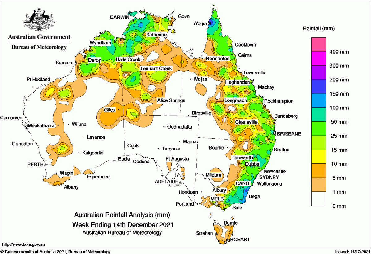
A CLOUDBAND and surface trough brought significant falls to the eastern seaboard throughout the past week, with registrations in excess of 100 millimetres on the New South Wales south coast and East Gippsland in Victoria.
A low pressure system that formed off the southern coast of NSW produced further moderate falls before moving away to the south east.
A surface trough along the east coast of Queensland triggered showers and thunderstorms about the Central Coast and Capricornia districts, as well as the far Cape York Peninsula.
Thunderstorm and shower activity continued across northern Australia throughout the week, extending from the Kimberley through the north and central Northern Territory and into north-eastern Queensland.
Past seven days: For the week to 14 December 2021, rainfall was recorded in northern and central Western Australia, across the north and central parts of the Northern Territory, northern and eastern Queensland, eastern New South Wales, the eastern half of Victoria, and small parts of Tasmania.
At the start of the week, a cloudband with embedded thunderstorms stretched from northern Queensland to eastern Victoria, east of a surface trough which extended from north-western and central Queensland, through inland New South Wales to East Gippsland in Victoria. A broad trough also extended across northern and western Australia Thunderstorms developed in central and northern Western Australia, and across large parts of the Northern Territory.
Thunderstorms and showers with moderate falls were again recorded across northern Australia extending from the Kimberley, the north and central Northern Territory and into north-eastern Queensland. The surface trough in the east triggered further showers and thunderstorms over central to south-eastern districts of Queensland.
The trough brought unsettled conditions to eastern New South Wales as it moved to the coast and weak low pressure system then formed off the southern coast of New South Wales, generating areas of heavy rainfall, with daily rainfall totals in excess of 100 mm in some parts of the South Coast District in New South Wales on the 10th.
In the last part of the week, the low pressure system moved south-east away from the coast of New South Wales, and produced further moderate falls across the South Coast District. The surface trough along the east coast of Queensland triggered showers and thunderstorms about the Central Coast and Capricornia districts, as well as across the far Cape York Peninsula.
Thunderstorms and showers continued across northern Australia to the end of the week, with isolated showers and thunderstorms developing over the Interior of Western Australia and south-west parts of the Northern Territory. Tropical cyclone Ruby formed in the Coral Sea on the 12th, then moved south-east out of the Australian Region into the South Pacific Region on the 13th.
Rainfall totals in excess of 100 mm were recorded in pockets of the Darwin-Daly District in the Northern Territory, around Weipa on the Cape York Peninsula, the South Coast District in New South Wales and in East Gippsland in Victoria. The highest weekly total was 215.2 mm at Brogo (Blanchards Road) in the South Coast District of New South Wales.
Rainfall totals between 50 mm and 100 mm were recorded in parts of the Kimberley in Western Australia, and in areas of the north-west and central west of the Northern Territory. Similar totals were reported in areas of northern, central and south-east Queensland, along much of eastern New South Wales, and the eastern third of Victoria.
Rainfall totals of 10 mm to 50 mm were recorded in northern and central Western Australia, northern and central parts of the Northern Territory, northern and the eastern half of Queensland, eastern New South Wales, and the eastern half of Victoria.
Highest weekly totals
New South Wales and Australian Capital Territory
215 mm Brogo (Blanchards Road)
204 mm Bettowynd (Nobbys Hill)
164 mm Moruya (Burra Creek)
Victoria
138 mm Mount Moornapa
137 mm Mallacoota
109 mm Gabo Island Lighthouse
Queensland
184 mm Scherger RAAF
175 mm Weipa Aero
120 mm Moreton Telegraph Station
Western Australia
72 mm Marion Downs, Napier Downs
70 mm Kachana
South Australia
4 mm Kapunda West (Kaplee)
3 mm Ernabella (Pukatja), Ashton
Tasmania
16 mm Gray (Dalmayne Rd)
15 mm Mount Read
14 mm Swansea (Francis Street)
Northern Territory
134 mm Mount Bundey South (Defence)
133 mm Adelaide River Post Office
128 mm Pirlangimpi Airport
Source: BOM
HAVE YOUR SAY