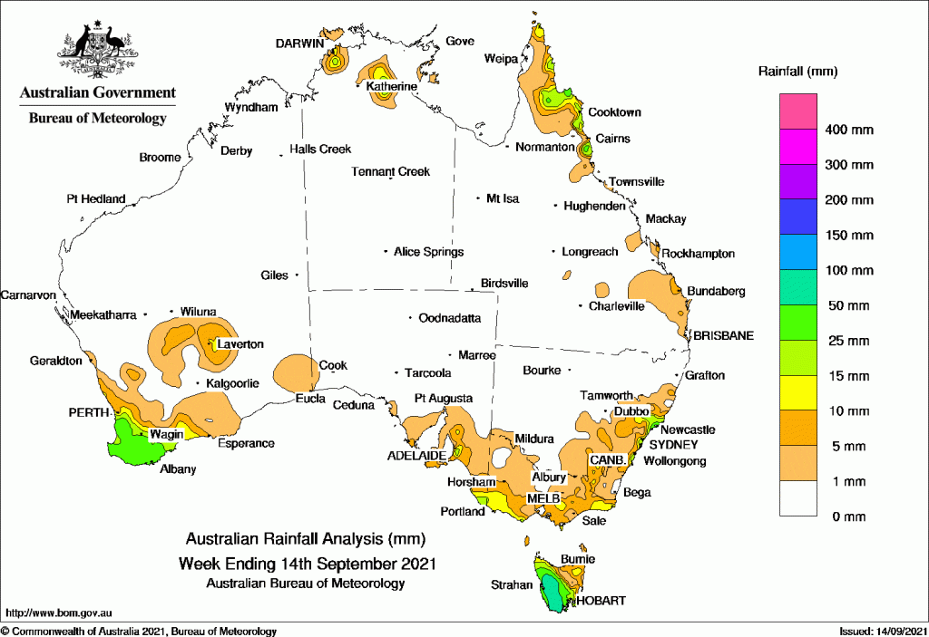
RAINFALL throughout the past week was largely confined to the south west and south east corners of the continent.
The heaviest falls were in south west Western Australia and Tasmania, with moderate falls extending into south-eastern South Australia, the southern half and far north-east of Victoria, and parts of eastern New South Wales.
Thunderstorms and showers brought moderate falls to the eastern Cape York Peninsula and North Tropical Coast of Queensland, and the north-western Top End in the Northern Territory.
Past seven days: For the week to 14 September 2021, rainfall was recorded in the south-west and the Goldfields District of Western Australia, western and southern Tasmania, south-eastern South Australia, the southern half and far north-east of Victoria, parts of eastern New South Wales including the Hunter District in the north. Rainfall was also recorded along the north Queensland east coast, and the north-west and south of the Top End in the Northern Territory.
In the first part of the week, a pre-frontal trough and associated cloudband, which extended from the central Indian Ocean to the Great Australian Bight, moved across the south-west of Western Australia, and was soon followed by a weak cold front. The southern part of the cloudband and a cold front moved across the south-east of Australia. Moderate rainfall was recorded in the south-west Western Australia, and the west and south of Tasmania.
At mid-week, thunderstorms and showers with moderate falls were reported in the eastern Cape York Peninsula and North Tropical Coast of Queensland. A cold front brushed the south-west coast of Western Australia, then tracked across the south-east of Australia, to produce mainly light rainfall in those regions, with moderate falls recorded in western Tasmania.
At the end of the week, the cold front continued to move eastward across New South Wales. Light rainfall was recorded in eastern New South Wales, and moderate falls were recorded along the state’s central coast and the Hunter District. The south-east Queensland recorded light rainfall as a trough moved through the southern parts of the state. Thunderstorms produced showers and moderate rainfall in the north-western Top End in the Northern Territory.
Rainfall totals between 50 mm and 100 mm were recorded in the Western and Central Plateau districts in Tasmania. The highest weekly rainfall was 108 mm at Mount Read in western Tasmania.
Rainfall totals between 10 mm and 50 mm were recorded in the south-west and pockets in the Goldfields in Western Australia; the far south-east and pockets in the Mount Lofty Ranges in South Australia, and the south-west, central and far north-east of Victoria. Similar totals were recorded in eastern New South Wales including the South West Slopes, lllawarra, Sydney Metropolitan and Hunter districts; the eastern Cape York Peninsula and North Tropical Coast in Queensland, and in the north-west and south of the Top End in the Northern Territory.
Highest weekly totals list and map
New South Wales and Australian Capital Territory
41 mm Mona Vale Golf Club
40 mm Williamtown Raaf
37 mm Newcastle (Blacksmiths), Upper Allyn Township
Victoria
22 mm Wilsons Promontory Lighthouse
20 mm Marlo, Cape Otway Lighthouse
Queensland
21 mm South Johnstone Exp Stn
20 mm Lockhart River Airport, Innisfail Aerodrome, Lotus Bird Lodge
Western Australia
47 mm Shannon
42 mm Tamar, Dwellingup
South Australia
24 mm Mount Bold Reservoir
23 mm Kangarilla (Saddlebags), Mount Barker
Tasmania
108 mm Mount Read
103 mm Lake Margaret Power Station
96 mm Lake Margaret Dam
Northern Territory
30 mm Knuckey Lagoon
29 mm Thorak Cemetery
24 mm Majestic Orchids


HAVE YOUR SAY