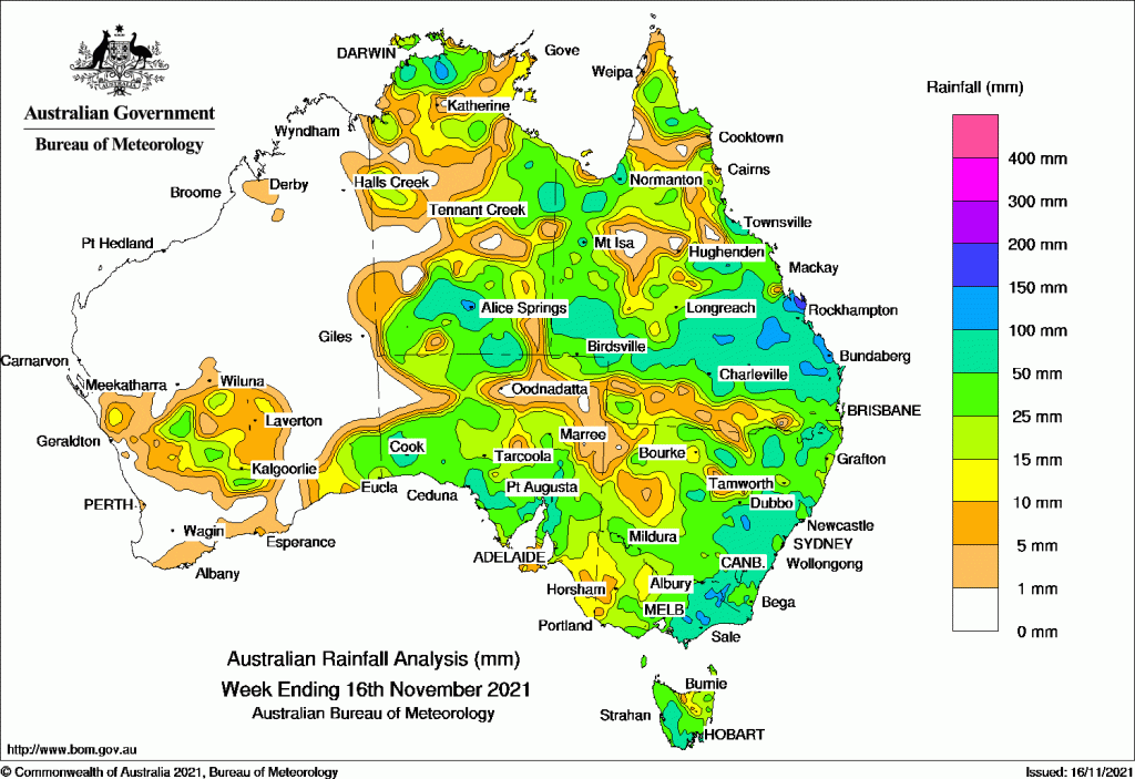
RAIN was widespread across the continent over the past week, except for the south west and north west parts of Western Australia.
Low pressure systems moved eastwards, bringing moderate to heavy falls to central Australia and the eastern states.
Falls in excess of 100 millimetres were recorded in central Australia, Central Queensland, south east New South Wales and eastern Victoria.
Later in the week a cold front tracked across south east Australia, bringing snow to elevated areas in Victoria, the Snowy Mountains in New South Wales, and parts of Tasmania, including Hobart.
Past seven days: At the start of the week, low pressure systems were located over inland Western Australia and western Queensland, with surface troughs extending through the interior and into northern Australia. Widespread thunderstorms and showers developed, with moderate falls in the Goldfields and Eucla districts in Western Australia, the West Coast and North West Pastoral districts in South Australia, Central Australia and the Top End in the Northern Territory, south-west Queensland, and large parts of eastern Queensland. Alice Springs reported a new November daily rainfall record of 100.2 mm on the 10th. Locally heavy daily falls in excess of 150 mm were recorded in the Capricornia District, including a November daily record of 340.8 mm at Samuel Hill AWS. A low pressure system crossed Tasmania, and the associated cold front tracked across the south-east, generating moderate falls in Tasmania and light falls in central southern to eastern Victoria.
The low pressure system over inland Western Australia moved into Central Australia, with multiple low pressure troughs extending from the low. Deep tropical moisture was drawn into central and eastern Australia, with widespread falls over 11 to 12 November across the Northern Territory, South Australia, Queensland (excluding the Cape York Peninsula), New South Wales, eastern Victoria, and southern Tasmania.
The low pressure system over Central Australia developed a cold front as it tracked across south-east Australia. Another low developed off the New South Wales coast and a trough extended north along the east coast of Queensland. Moderate falls were recorded from the Cape York Peninsula to the Fraser Coast in Queensland, in southern New South Wales, and central to eastern Victoria, with heavy falls in parts of Gippsland.
At the end of the week, thunderstorms developed across the Top End of the Northern Territory, and the far north of Cape York Peninsula. In the south, a cold front tracked across south-east Australia and brought light to moderate falls to parts of southern and north-eastern Victoria, elevated areas of the Snowy Mountains in New South Wales, and western Tasmania. Snow was reported at elevated areas in Victoria, the Snowy Mountains in New South Wales, and in parts of Tasmania, including Hobart. Moist onshore flow produced locally heavy falls around Townsville early on the 16th, with more than 90 mm in one hour at Alva Beach, and 181 mm to 9am on the 16th.
Rainfall totals in excess of 100 mm were recorded in some locations in the north and the south of the Northern Territory; parts of western and central Queensland; parts of the Hunter, Central Tablelands and areas of the Snowy Mountains districts in New South Wales; and pockets of West Gippsland in Victoria. Isolated falls in excess of 150 mm were recorded in the Capricornia and Herbert and Lower Burdekin districts of Queensland. The highest weekly rainfall total was 421 mm at Samuel Hill AWS, north of Yeppoon.
Rainfall totals between 50 mm and 100 mm were recorded in parts of southern South Australia; pockets of the northern, eastern and southern Northern Territory; western and southern parts of Queensland; eastern New South Wales; eastern Victoria; and areas of western to southern Tasmania.
Rainfall totals of 10 mm to 50 mm were recorded in inland southern Western Australia, most of the Northern Territory except parts of the west; most of South Australia except the north-west and far south-east; and most of the remainder of the eastern states.
Highest weekly totals
New South Wales and Australian Capital Territory
133 mm Orange Airport AWS
125 mm Blackville (Krui Vale)
122 mm Orange Agricultural Institute
Victoria
162 mm Mount Moornapa
159 mm Mount Baw Baw
153 mm Balook
Queensland
421 mm Samuel Hill Aero
238 mm Alva Beach
232 mm Byfield Childs Road
Western Australia
33 mm Forrest
26 mm Kirkalocka
24 mm Kambalda West
South Australia
83 mm Georgetown
72 mm Wirrulla
71 mm Multiple locations
Tasmania
110 mm Fern Tree (Westringa Road)
82 mm Lake Margaret Dam
81 mm Leslie Vale, Fortescue Bay
Northern Territory
137 mm Cooinda Airstrip
118 mm Alice Springs Airport
117 mm Alice Springs Desert Park
![]()
HAVE YOUR SAY