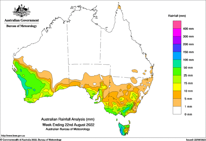
AT the start of the week, a cold front interacted with a moisture-laden cloud band to bring heavy rain to the mid-west and Gascoyne regions of Western Australia, resulting in daily totals around 20-70 millimetres to 9am on August 16, with many sites setting August daily records.
A succession of cold fronts crossed south-eastern Australia later in the week, bringing daily totals of around 25-50mm to western-facing areas on several occasions.
Weekly rainfall totals around 100-150 mm were recorded in western Tasmania, and weekly totals around 25-100 mm were recorded in WA in the Gascoyne and South West Land Divisions, north-eastern Tasmania, and much of Victoria west of the Dividing Range.
Moderate weekly rainfall totals of around 10-25mm, locally up to 50mm, were recorded along the western slopes regions in New South Wales and Agricultural Districts of South Australia.
Near-major flooding continues along the Macquarie River downstream of Burrendong Dam, and there is minor to moderate flooding at a number of other rivers in NSW, Victoria and Tasmania.
The highest weekly total at a Bureau gauge was 146.8mm at Mount Read in western Tasmania and the highest daily total at a Bureau gauge was 77mm at Lynton, WA, in the 24 hours to 9am on August 16.
HAVE YOUR SAY