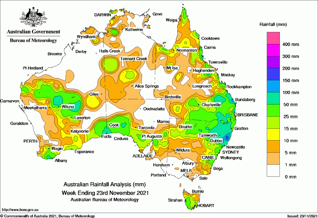
RAINFALL was widespread throughout Australia over the past week, except for the grainbelt regions of Western Australia and much of Victoria.
A surface trough that moved eastwards across the continent earlier in the week brought showers and storms to many parts, followed by a second trough that stretched across the continent mid-week.
Towards the end of the week a tropical low pressure system off north-west Australia developed into the first tropical cyclone of the season and pushed moist air over the continent, bringing further falls.
Heavy falls are forecast for eastern Australia over the coming week.
Past seven days: For the week to 23 November 2021, rainfall was recorded across large parts of north-western, central, and southern Western Australia, central and north-west parts of the Northern Territory, southern South Australia, far eastern Victoria, most of Tasmania, the northern half and eastern New South Wales, and in northern, eastern and southern Queensland.
At the start of the week, a surface trough extending through inland Queensland combined with moist onshore flow and produced showers and thunderstorms along the east coast of Queensland, with moderate falls about the north tropical coast, around Townsville, and the Wide Bay coast.
A broad area of low pressure was located over Western Australia, with surface troughs extending across South Australia to a low pressure system in the Great Australian Bight. The trough tracked eastward, with the low connecting to a weak cold front and crossing Tasmania around mid-week. Showers and storms produced light to moderate falls through inland and southern Western Australia, southern South Australia, southern New South Wales, and the southern two-thirds of Tasmania.
Thunderstorms and showers also developed across Cape York Peninsula and the north tropical Queensland coast, parts of the Gulf Country and parts of the north-west Top End in the Northern Territory.
From mid-week, an extensive trough stretched from the north-west through central Australia to New South Wales, drawing tropical moisture down from the Indian Ocean. Widespread moderate falls were recorded in south-west and southern inland Queensland, north-west and central to eastern parts of New South Wales.
In the last part of the week, a tropical low pressure system off north-west Australia developed into tropical cyclone Paddy, the first tropical cyclone of the 2021–22 season, providing consistent moderate rainfall to Christmas Island, 1500 km west of the Australian mainland.
The low pressure trough which had persisted along the west coast of Australia during the week deepened at the end of the week, with a low pressure centre developing over the south-west and an associated cold front then tracking eastward in the last days of the week. Widespread moderate falls were recorded in the north-west, central and the south-west parts of Western Australia.
A trough across northern Australia also persisted through the second half of the week. Thunderstorms and showers brought widespread moderate falls to the north-west and larges areas of southern Queensland, and most of northern New South Wales except the far north-west, extending along most of that state’s north-east to central coasts.
At the end of the week, a low pressure system and upper-level disturbance over the central Queensland coast brought thunderstorms and moderate to locally heavy rainfall to much of the east coast south of Proserpine, extending west into the Central Highlands, and south to the Darling Downs and parts of the Warrego and Maranoa districts of Queensland. A coastal trough also produced widespread moderate falls in north-eastern and the central coast of New South Wales.
Rainfall totals in excess of 100 mm were recorded in pockets around the Herbert and Lower Burdekin, the Wide Bay coast, and southern parts of the Central Highlands into the Darling Downs in Queensland; also in the Mid North Coast District in New South Wales. The highest weekly total was 240 mm at Yarras (Mount Seaview) in the Mid North Coast District in New South Wales.
Rainfall totals between 50 mm and 100 mm were recorded in small areas in central and south-west Western Australia, the far south-east of Western Australia and bordering areas of far south-west South Australia, north-east New South Wales extending into the south-east inland of Queensland, and parts of east coast Queensland.
Rainfall totals of 10 mm to 50 mm were recorded in north-west, central and southern Western Australia; southern and north-west parts of the Northern Territory; southern South Australia; most of Tasmania away from the north; far eastern Victoria; northern and eastern New South Wales; and northern, eastern and southern parts of Queensland.
Highest weekly totals
New South Wales and Australian Capital Territory
240 mm Yarras (Mount Seaview)
218 mm Mooral Creek (The Den)
189 mm Upper Pappinbarra (Hillcrest)
Victoria
20 mm Combienbar AWS
18 mm Falls Creek
17 mm Mount Buller
Queensland
129 mm Hawkins Creek
128 mm Southwood
125 mm Bundaberg Aero
Western Australia
67 mm Cunyu
64 mm Eucla
58 mm Neds Creek, Denbarker
South Australia
43 mm Maralinga, Mount Ive
42 mm Nullarbor
Tasmania
36 mm Mount Barrow (South Barrow)
35 mm Mount Read
32 mm Fern Tree (Westringa Road), kunanyi / Mount Wellington
Northern Territory
48 mm Bradshaw
35 mm Labelle Downs
32 mm Pirlangimpi Airport
![]()
HAVE YOUR SAY