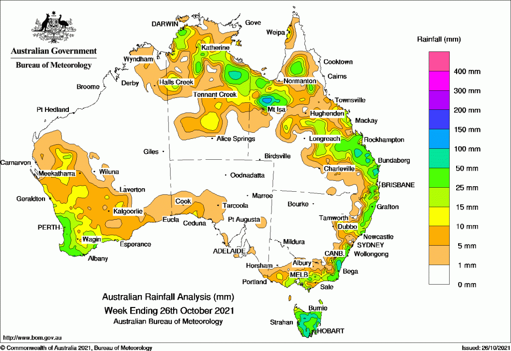
RAINFALL was widespread around the perimeter of Australia over the past week.
A cold front in Western Australia and troughs in the east bringing light to moderate falls to those parts early in the week.
That was followed by a broad area of low pressure extending from northern to south eastern Australia which, along with a cold front across Tasmania and Victoria, produced thunderstorms and moderate falls.
By weeks’ end, a cold front over south east WA brought moderate falls to the region and a trough across Queensland and the Northern Territory continued to produce thunderstorms and showers across Australia’s north.
Past seven days: For the week to 26 October 2021, rainfall was recorded in the South West Land Division, and inland Gascoyne in Western Australia, in the north and central parts of the Northern Territory, in the north, central and east of Queensland, eastern New South Wales, eastern and central Victoria, and Tasmania.
At the start of the week, a cold front and associated cloudband moved across Western Australia, and produced light rainfall to the western half of the state, with moderate falls along the coastal south-west and inland Gascoyne. Light rainfall was also recorded across the state’s south coast and the Nullarbor in South Australia. In the east, a trough extended across inland Queensland to the central coast and triggered severe thunderstorms with giant (greater than 5 cm in diameter) to gargantuan (greater than 15 cm in diameter) hail around the Mackay area. Showers with light falls was recorded in the central and south-east coast. Another trough produced moderate rainfall along the north-east New South Wales coast. A severe thunderstorm brought hail and heavy rainfall to Coffs Harbour. An onshore flow produced showers with light to moderate rainfall along the central and south coast of New South Wales coast, and eastern Victoria.
At mid-week, a broad area of low pressure persisted and extended across northern Australia to southern Queensland and south-east Australia, to produce thunderstorms and moderate falls in parts of the north and central Northern Territory; north, central and south-east Queensland; and the central New South Wales coast and further inland. A cold front moved across Tasmania and Victoria and resulted in widespread moderate rainfall to Tasmania, but mostly light falls to southern and eastern Victoria.
At the end of the week, a cold front tracked across south-west Western Australia, and a trough was located near the south-west coast, bringing light to moderate falls to the region. A thunderstorm with small hail was recorded in Perth’s surburb of Bentley. A trough extending across Queensland and the Northern Territory to the Kimberley continued to produce thunderstorms and showers. Moderate rainfall was recorded in the north-western Top End and the Carpentaria District in the Northern Territory, the Capricornia District and adjacent Central West District, and the Wide Bay and Burnett District in Queensland.
Rainfall totals in excess of 50 mm were recorded areas in the South Coast and Mid-North Coast districts in New South Wales; the North West, the Capricornia, and Wide Bay and Burnett districts in Queensland; and the West, Central Plateau, North Central and East Coast districts in Tasmania. Spots in the Carpentaria District of the Northern Territory, and in the Perth hills in Western Australia also recorded similar weekly rainfall totals. The highest weekly rainfall was 142.6 mm at Mount Barrow in the north-east of Tasmania.
Rainfall totals between 10 mm and 50 mm were recorded through inland parts of the Gascoyne and most of the South West Land Division of Western Australia, around central and eastern Victoria, Tasmania, along the coast of New South Wales, in the north, central and eastern parts of Queensland south of Townsville, and in the north and central parts of the Northern Territory.
Highest weekly totals
New South Wales and Australian Capital Territory
128 mm Bellwood (Nambucca Heads)
122 mm Tweed Heads Golf Club
111 mm Evans Head RAAF
Victoria
92 mm Ferny Creek
91 mm Kinglake West
85 mm Mount Baw Baw
Queensland
130 mm Springbrook Road
125 mm Clontarf
124 mm Manly Railway Station
Western Australia
32 mm Lancelin (Defence)
27 mm Jurien Bay
26 mm North Island, Kalbarri
South Australia
72 mm Wirrabara Forest
47 mm Crafers West
46 mm Felixstow (Payneham)
Tasmania
241 mm Gray (Dalmayne Rd)
190 mm Pyengana (Forest Lodge Road)
126 mm Mount Barrow (South Barrow)
Northern Territory
56 mm Labelle Downs
32 mm Fanny Creek
31 mm Upper Seventeen Mile Creek
![]()
HAVE YOUR SAY