RAINFALL for the past week fell in the south-west of Western Australia, south east Victoria, Tasmania, parts of eastern New South Wales, and central inland Queensland.
From the middle of the week, a pair of cold fronts tracked over Tasmania, generating moderate falls in the state’s west and north-east, and light falls across southern Victoria.
Towards the end of the week, a surface trough extending through inland Queensland triggered showers and thunderstorms over the Central Highlands District.
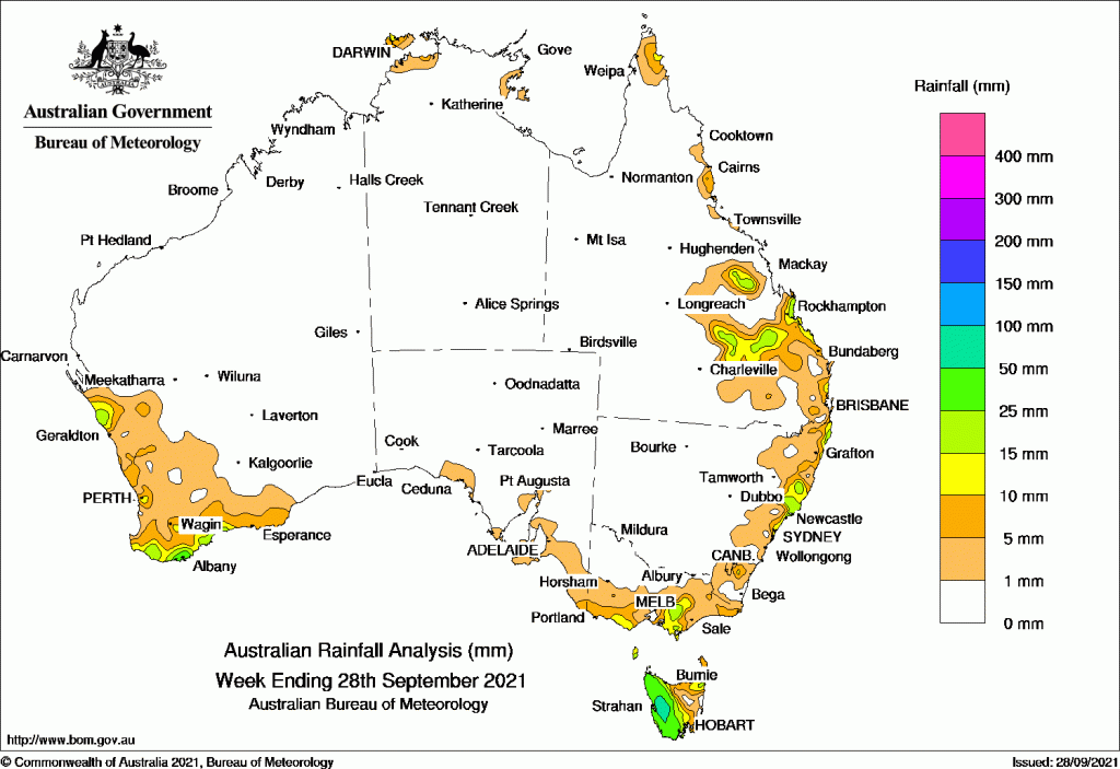
Past seven days: For the week to 28 September 2021, rainfall was recorded in the south-west of Western Australia and pockets in the Central West District, southern and west Gippsland in Victoria, much of Tasmania, parts of the central and north coast of New South Wales, and areas of the east coast and Central Highlands District in Queensland.
At the start of the week, a south-westerly airstream brought mostly light falls to south-east South Australia, southern and eastern Victoria, and western Tasmania. Onshore flow generated showers in parts of the central coast of New South Wales.
From the middle of the week, onshore flow produced showers about the central and north tropical coasts of Queensland. A pair of cold fronts tracked over Tasmania and generated moderate falls in the state’s west and north-east, and light falls across southern Victoria. As the front moved eastwards, a surface trough extended from south-east to north-west Queensland. Showers produced mostly light falls along the central to north-east coasts of New South Wales and south-east Queensland.
In the last part of the week, a surface trough developed along the west coast of Western Australia, and a low formed near the south-west coast. The systems moved across southern parts of the state. Thunderstorms and showers with light to moderate falls were recorded in western and southern parts of the state, extending from the Central West District down to the South Coastal and South East Coastal districts.
At the end of the week, the surface trough extending through inland Queensland triggered showers and thunderstorms over the Central Highlands District and adjacent areas, with moderate falls reported.
Rainfall totals in excess of 50 mm were recorded in western Tasmania, including the highest weekly rainfall total of 84 mm at Mount Read.
Rainfall totals between 10 mm and 50 mm were recorded in south-west Western Australia, as well as parts of the Central West District; parts of southern Victoria, most of Tasmania except the east coast and inland north-east, the central and north coast of New South Wales, and along the east coast and Central Highlands District in Queensland.
Highest weekly totals list and map
New South Wales and Australian Capital Territory
60 mm Yarras (Mount Seaview)
43 mm Mooral Creek (The Den)
41 mm Byron Bay (Jacaranda Drive)
Victoria
39 mm Mount Baw Baw
24 mm Balook
21 mm Boolarra South
Queensland
31 mm Byfield Childs Road
27 mm Broadmeadows
26 mm Pacific Heights
Western Australia
42 mm Tamar
39 mm Albany Airport
36 mm Albany
South Australia
7 mm Kangarilla (Saddlebags), Crafers West
6 mm Multiple locations
Tasmania
84 mm Mount Read
80 mm Lake Margaret Dam
73 mm Warra
Northern Territory
16 mm Pirlangimpi Airport
11 mm Charles Point
5 mm Point Stuart, Noonamah Airstrip
![]()
HAVE YOUR SAY