THUNDERSTORMS, showers, hail and snow in the south-east of Australia at the beginning of the week were followed by settled conditions due to a slow-moving high-pressure system centred south of the continent.
A low-pressure trough brought showers and isolated thunderstorms to the south-east of Australia in the last two days of the week.
 There were widespread showers and thunderstorms across much of the tropics during the week.
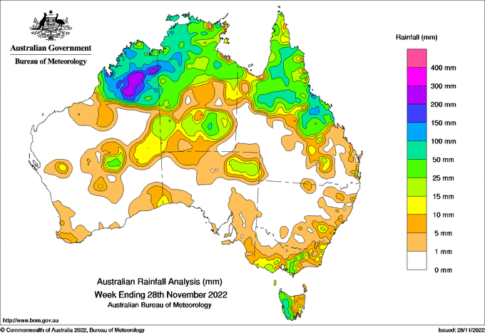
Weekly rainfall totals above 50 millimetres were recorded in large areas in the north of the continent and in western Tasmania.
Weekly totals above 100mm were recorded in parts of the Kimberley district in Western Australia, Darwin-Daly and Victoria Rivers districts in the Northern Territory, and Central Highlands district and pockets of Herbert and Northern Goldfields districts in Queensland.
The highest weekly total at a Bureau gauge of 309mm was recorded at Lansdowne, WA; the highest daily total this week was 146mm at Marrara, NT, in the 24 hours to 9am on November 28.
Rainfall totals of 10-50mm were recorded in parts of central Western Australia, much of the Northern Territory and northern Queensland, north-eastern South Australia, southern and north-eastern Victoria and much of Tasmania.
Major flooding continues along the Murray River and in many rivers in inland New South Wales.
HAVE YOUR SAY