TROUGHS extending across the eastern seaboard and through western Queensland to northern New South Wales brought rain to large areas of eastern and northern Australia early in the past week.
In the middle of the week a pre-frontal trough extending across South Australia and Victoria moved east through NSW and southern Queensland, bringing light to moderate rainfall.
Towards the end of the week, a trough across northern Australia and down through both the western and eastern sides of the continent, triggered thunderstorms and showers across large parts of northern and eastern Australia.
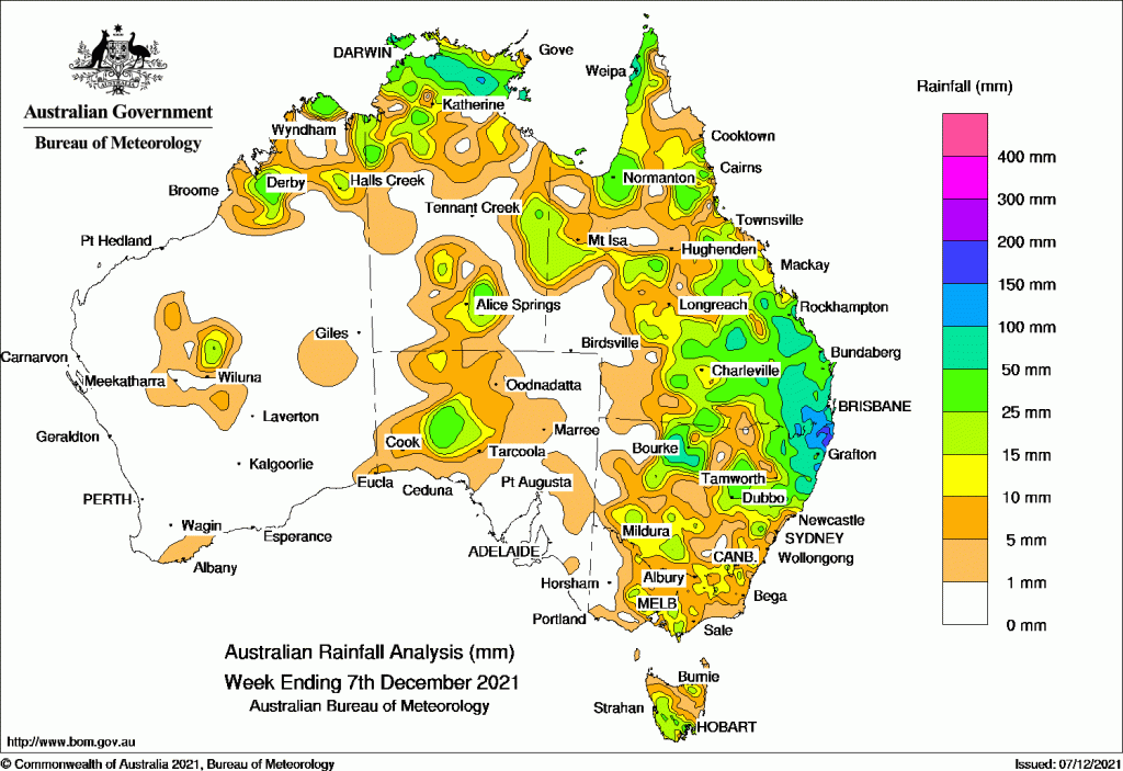
Past seven days: For the week to 7 December 2021, rainfall was recorded in large areas of the eastern and northern Australia. Areas in the North West Pastoral District in South Australia and central Western Australia also recorded rainfall.
At the start of the week, troughs extended across the eastern seaboard and through western Queensland to northern New South Wales. These combined with an upper level trough and onshore flow, producing thunderstorms and showers in eastern and southern Queensland and northern New South Wales. Daily rainfall between 50 mm and 100 mm was recorded in the North Rivers District in New South Wales and in south-eastern Queensland. Multiples stations observed record-high December daily rainfall totals.
Rainfall eased and contracted to coastal south-east Queensland and north-eastern New South Wales as the trough moved away from the east coast. Light rainfall was recorded in southern and central New South Wales, and northern and central Victoria. Thunderstorms and showers were reported in the Top End in the Northern Territory and in western Cape York and the Gulf country in Queensland.
During the middle part of the week, a number of weak cold fronts moved across Tasmania, while a pre-frontal trough extending across South Australia and Victoria moved east through New South Wales and southern Queensland. Light to moderate rainfall was recorded in Victoria and Tasmania, and the south of New South Wales, and moderate rainfall in Queensland’s coastal south-east and north-east New South Wales. Thunderstorms produced light to moderate rainfall in the North West Pastoral district in South Australia.
In the last part of the week, a trough extended across northern Australia and down through both the western and eastern sides of the continent, triggering thunderstorms and showers across large parts of northern and eastern Australia, and in the North West Pastoral District in South Australia.
For the week as a whole, rainfall totals in excess of 100 mm were recorded in far south-eastern Queensland and far north-eastern New South Wales. The highest rainfall for the week was 293.6 mm at Evans Head RAAF Bombing Range AWS in the Northern Rivers District in New South Wales.
Rainfall totals between 50 mm and 100 mm were recorded in the north-east and north-west of New South Wales, areas in southern and central Queensland, and the Top End of the Northern Territory.
Rainfall totals of 10 mm to 50 mm were recorded in the Kimberley and central Western Australia; the north, east and south of the Northern Territory; most of Queensland except the Channel Country; most of New South Wales away from the western border; central Victoria and south Gippsland; the south-western half and north-east of Tasmania; and the North West Pastoral District in South Australia.
Highest weekly totals
New South Wales and Australian Capital Territory
294 mm Evans Head Raaf Bombing Range
198 mm New Italy (Vineyard Haven)
191 mm Ballina Airport Aws
Victoria
35 mm Maryborough
34 mm Boolarra South
28 mm Essendon Airport
Queensland
191 mm Yuleba Garden St
169 mm Beaudesert Drumley Street
148 mm Yeppoon The Esplanade
Western Australia
51 mm Kalumburu
45 mm Debesa
38 mm Curtin Aero
South Australia
25 mm Tarcoola (Mobella)
21 mm Tarcoola (Commonwealth Hill), Tarcoola (Mulgathing)
Tasmania
52 mm Fern Tree (Westringa Road)
46 mm Kunanyi (Mount Wellington Pinn
42 mm Longley (River Bend Road)
Northern Territory
98 mm East Arm
93 mm Jabiru Airport
87 mm Bulman


HAVE YOUR SAY