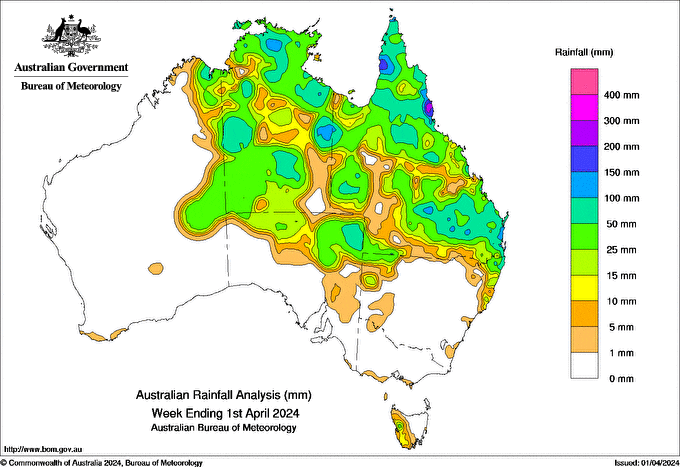
THROUGHOUT the week, a series of troughs that drew tropical moisture south moved across Queensland, Northern Territory, northern South Australia and north-western New South Wales and generated widespread rainfall.
A coastal trough developed over south-eastern Queensland resulting in moderate to high rainfall and a cold front moved across western Tasamania bringing light to moderate rainfall.
Weekly rainfall totals of 100-200mm were recorded in isolated pockets of the Top End and eastern parts of the NT and northern and south-eastern parts of Qld, with greater than 300mm in coastal areas of Qld’s North Tropical Coast and Tablelands district.
Weekly rainfall totals of 50-100mm were recorded across areas of Qld, north-eastern SA and central and northern parts of the NT.
Weekly rainfall totals of 25-50mm were recorded across much of Qld and the NT, north-eastern SA extending into NSW, the Southern Interior district of Western Australia, and an area of north-western Tasmania.
The highest weekly rainfall total was 308mm at Menavale Alert in Qld.
The highest daily rainfall total during the week was 131mm at Mt Sophia in Qld, in the 24 hours to 9am on March 29.
HAVE YOUR SAY