Past seven days: At the start of the week, a low pressure system south of the Great Australian Bight produced showers and storms, with light to moderate falls recorded over southern South Australia, Victoria, southern New South Wales, and western Tasmania. In the west, light to moderate falls were also recorded along the west and south coasts of Western Australia from onshore winds.
A series of surface troughs, associated with the slow moving low pressure system in the Bight, extended north into central Australia, and across eastern states. Thunderstorms and showers, and areas of rain developed in southwest Queensland, northwest and to southern inland parts of New South Wales, over much of Victoria, and Tasmania.
By the middle of the week, a large cloudband had developed over inland Queensland, New South Wales and northeast Victoria as a trough and a cold front moved across those regions and generated widespread falls from central to south-east Queensland, New South Wales, most of Victoria and Tasmania. Moderate falls were recorded over parts of inland south-east Queensland, and north-eastern, central and south-east New South Wales, eastern Victoria and north-east Tasmania.
A complex low pressure system deepened near the New South Wales and northeast Victoria coast, and continued to produce moderate falls over eastern Victoria, and northern and eastern Tasmania, with minor to moderate flooding in parts of eastern Victoria and northeast Tasmania.
In the last part of the week, a cold front tracked across the west coast of Western Australia, with a low pressure system moving through the south coast. Widespread moderate falls were recorded along the west coast and adjacent inland districts, with light falls recorded across large parts of the South West Land Division. The weakening cold front tracked across South Australia and south-eastern Australia, while a complex low pressure system moved into the Bight. Further light falls were reported over south-east South Australia, western and northern Victoria, and northern Tasmania.
Rainfall totals in excess of 100 mm were recorded in parts of north-east Tasmania and far eastern Victoria. The highest weekly total was 217 mm at Gray (Dalmayne Road) in the East Coast District in Tasmania.
Rainfall totals in excess of 50 mm were recorded along far south-west coast of Western Australia, small areas on Kangaroo Island and the Mount Lofty Ranges in South Australia, parts of eastern Victoria, elevated areas in the Snowy Mountains in New South Wales, and parts of northern and eastern Tasmania.
Rainfall totals between 10 mm and 50 mm were recorded along the west and south coasts, and adjacent inland districts of Western Australia, southern and parts of eastern South Australia, most of Victoria, Tasmania, larges areas of New South Wales, and in south-west and south-eastern Queensland.
Highest weekly totals
New South Wales and Australian Capital Territory
65 mm Mount George (Manning River), Dalmeny (Binalong St)
58 mm Cabramurra
Victoria
124 mm Cann River
119 mm Club Terrace
109 mm Mallacoota
Queensland
47 mm Queen Mary Falls
44 mm Applethorpe
40 mm Stanthorpe Leslie Parade
Western Australia
85 mm Denmark
70 mm Cheyne Beach
69 mm North Walpole
South Australia
68 mm Parndana (Turkey Lane)
56 mm Parawa (Second Valley Forest A
45 mm Cape Willoughby
Tasmania
217 mm Gray (Dalmayne Rd)
113 mm Kunanyi (Mount Wellington Pinn
90 mm Friendly Beaches
Northern Territory
0.6 mm Dum In Mirrie Airstrip
0.4 mm Shoal Bay, Ngayawili, Centre Island
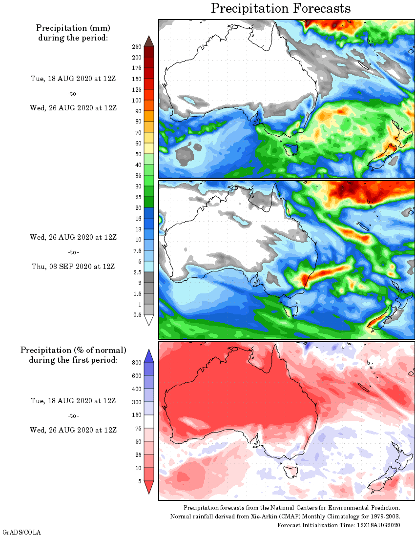
Rainfall outlook
HAVE YOUR SAY