For today’s 14-day rainfall outlook – scroll to bottom of article
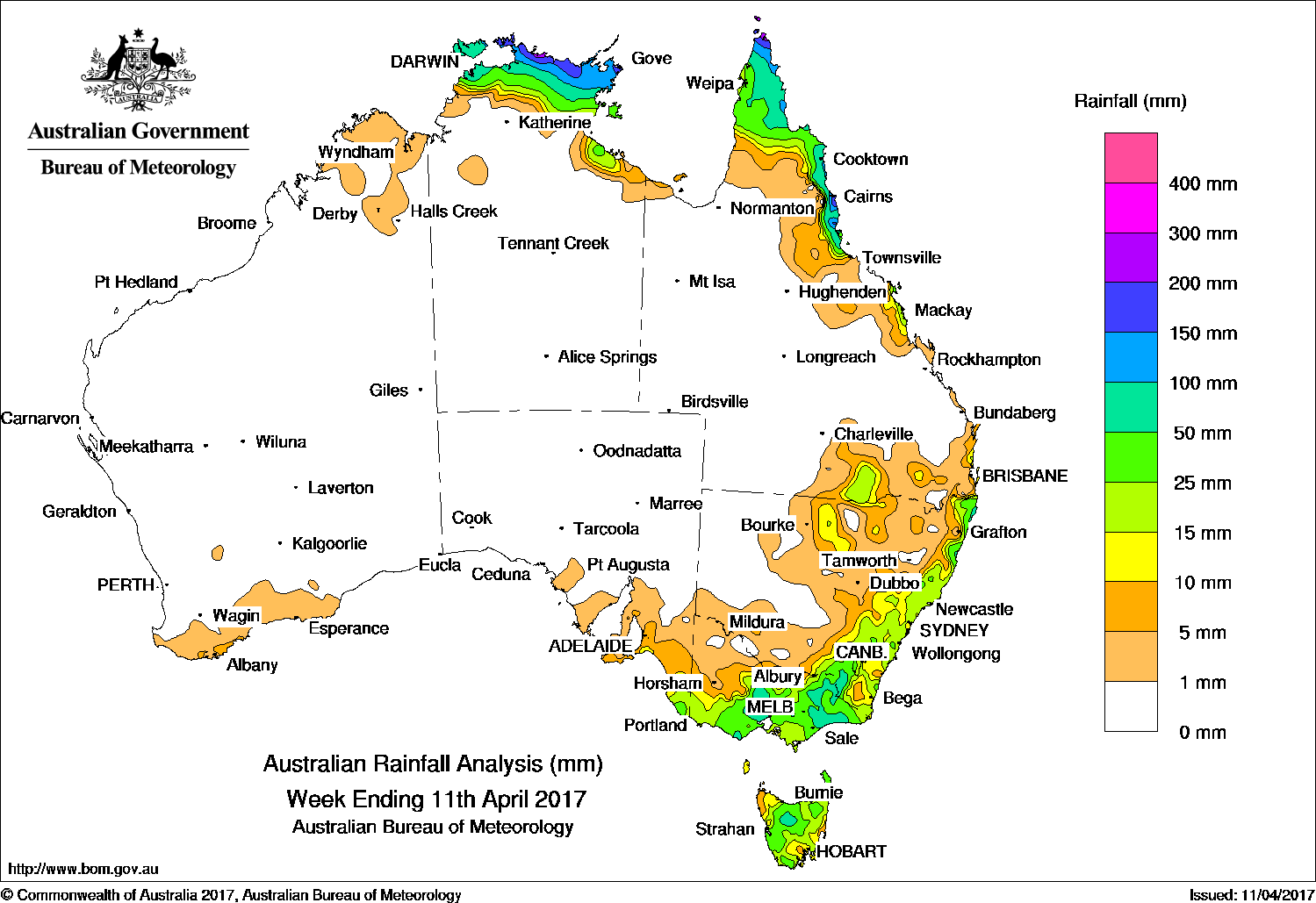
In a drier week for Australia nationally rainfall was recorded in the coastal Top End in the Northern Territory; the Cape York Peninsula, the north tropical, central and southeastern coast, and southern Queensland; northern and eastern New South Wales; and in southeastern South Australia Victoria and Tasmania. Light falls were recorded about the far north and south coasts of Western Australia.
Past seven days: At the start of the week, a fresh southeasterly flow along the east coast of Australia produced isolated showers along the New South Wales and north tropical Queensland coasts. Moderate falls were recorded between about Coen in the eastern Cape York Peninsula coast down to Ingham, while mostly light falls were recorded along the east coast of New South Wales. An inland surface trough located through western Queensland and New South Wales was responsible for isolated thunderstorms developing throughout parts of northern New South Wales and southern Queensland early in the week.
In the middle of the week, a number of cold fronts and surface troughs tracked from the southwest to southeast of the country. Light falls were recorded along the Albany and Esperance coasts. Areas of middle to high level cloud with embedded thunderstorms produced moderate falls extending from the South Australian coast to southwest, central and northeastern Victoria, and Tasmania. During the second half of the week a cold front and associated low pressure system, which developed over Bass Strait, tracked across the southeastern mainland and Tasmania. A band of middle level cloud with embedded thunderstorms produced moderate to heavy falls in southeastern South Australia, large parts of central and northeastern Victoria, southeastern New South Wales, and northern Tasmania. Some flash flooding and storm damage resulted.
The monsoon trough north of Australia triggered isolated showers and storms, with moderate totals recorded in the coastal Top End of the Northern Territory and about the Cape York Peninsula during the week. A tropical low developed along the monsoon trough in the Arafura Sea towards the end of the week, which further enhanced rainfall in the far north of the Top End.
Rainfall totals between 200 mm and 300 mm were recorded in pockets in each of the north tropical coast in Queensland, the far northern tip of Cape York Peninsula, and the central coast of the Top End in the Northern Territory.
Rainfall totals between 100 mm and 200 mm were recorded in the Top End from Croker Island to the northern parts of Arnhem Land in the Northern Territory; some locations in southern Victoria; and in isolated pockets from the northern tip of the Cape York Peninsula to the north tropical Queensland coast.
Rainfall totals between 50 mm and 100 mm were recorded in the coastal parts of the Top End including the Tiwi Islands, much of the northern Cape York Peninsula and along the north tropical Queensland coast between about Cooktown and Townsville; pockets of the northeast coast and elevated parts of southeastern New South Wales; in central southern and eastern parts of Victoria; and in the north of Tasmania.
Rainfall totals between 10 mm and 50 mm were recorded in remaining parts of the northern Top End and around Centre Island in the Northern Territory; the northern half of the Cape York Peninsula and along the northeast and central coast, and in parts of southeastern and southern Queensland. Similar totals were recorded in parts of northern New South Wales, along the east coast of New South Wales and across much of Victoria except the northwest, extending in southeastern South Australia, and also across most of Tasmania. Very light falls were reported in the far northern and southern coasts of Western Australia, central New South Wales, northwestern Victoria and the southeast coast of South Australia.
Little or no rainfall was recorded in Western Australia, South Australia away from the southeast, most of the Northern Territory except the far northern Top End; western and central Queensland away from the east coast, and western New South Wales.
Highest weekly totals
New South Wales and Australian Capital Territory
94 mm Rockley Post Office
82 mmPerisher Valley AWS
74 mm Thredbo Village
Victoria
118 mm Bullumwaal
114 mm Durdidwarrah
109 mm Reeves Knob
Queensland
283 mm Tully Sugar Mill
229 mm Mt Sophia
186 mm Horn Island
Western Australia
11 mm Lansdowne, Tamar
9 mm Denbarker
South Australia
20 mm Millicent
17 mm Nangwarry Forestry
16 mm Kalangadoo
Tasmania
53 mm Liawenee
52 mm Railton (Dowbiggin Street)
45 mm Meander (Meander River)
Northern Territory
242 mm Warruwi Airport
214 mm Mccluer Island
187 mm Yirrkala Tropical Gardens
More weekly rainfall totals:
- NSW/ACT totals click here
- Vic totals click here
- Qld totals click here
- WA totals click here
- SA totals click here
- Tas totals click here
- NT totals click here
Source: BOM


HAVE YOUR SAY