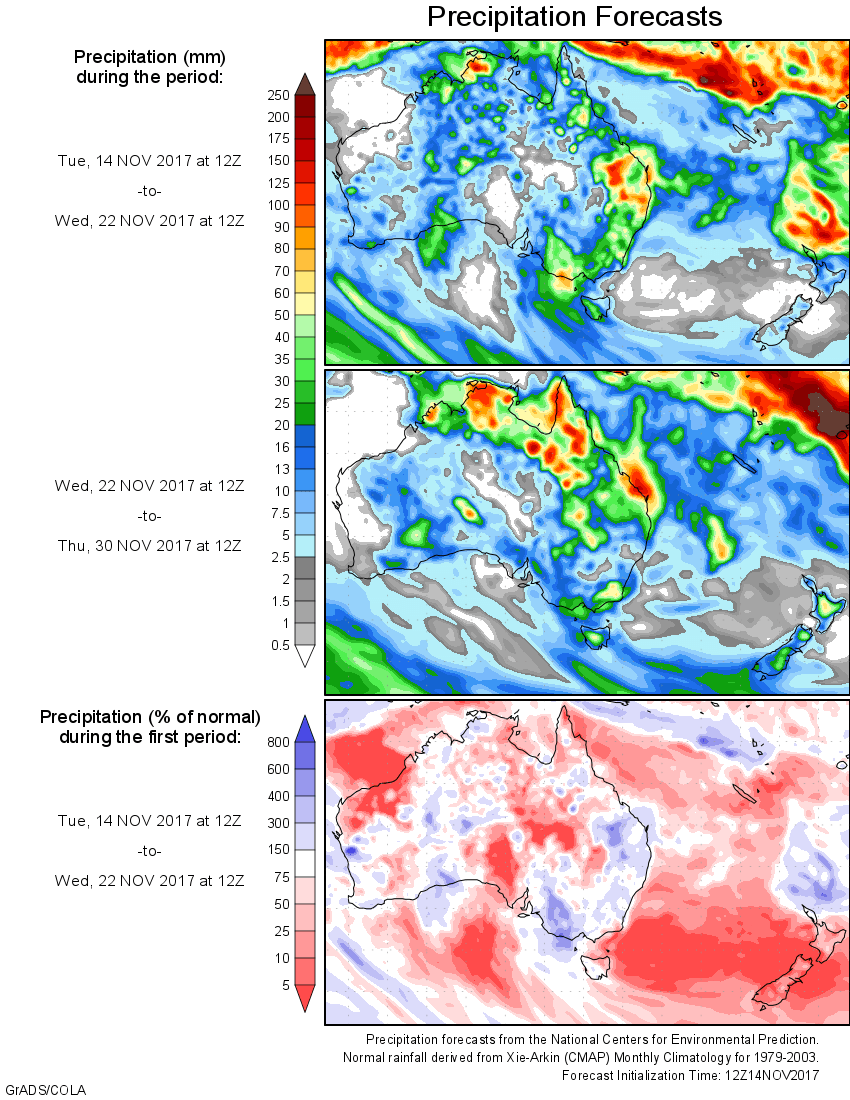
For today’s 14-day rainfall outlook – scroll to bottom of article
Surface troughs produced thunderstorms with moderate falls in parts of the west, north and east of Australia. A persistent easterly onshore flow produced moderate to heavy falls over the north tropical coast of Queensland
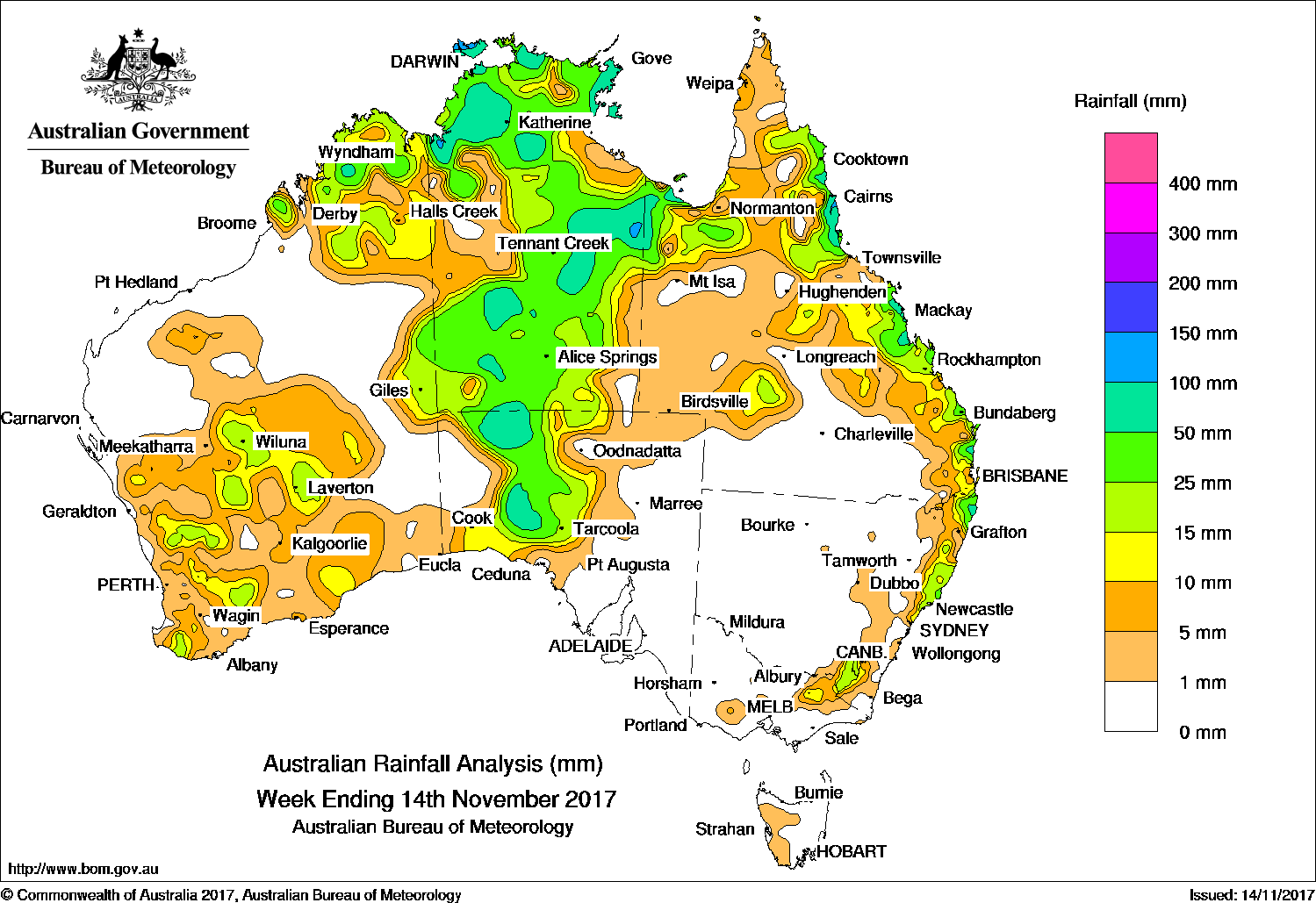
Past seven days: At the beginning of the week, a broad surface trough extended across northern Australia and inland down the west and east coasts of the country. Associated thunderstorms and showers formed along the New South Wales and east Queensland coasts; the Top End of the Northern Territory; the Kimberley, Goldfields and inland South West Land Division in Western Australia. The trough along inland Queensland moved westwards and generated showers and isolated thunderstorms in the State’s west and about the Gulf Country, while a moist onshore flow produced moderate to locally heavier falls about the north tropical coast.
From the middle of the week, broad surface troughs dominated the north, west and central Australia, as a strong high pressure system moved slowly across southern Tasmania into the Tasman Sea, with a ridge extending along the eastern seaboard. The surface troughs interacted with an upper-level disturbance, producing extensive cloudbands with embedded clusters of thunderstorms stretching from the Kimberley, through the Northern Territory to north, central and southwest of South Australia. Moderate to locally heavy falls were recorded across much of the Northern Territory, central Australia and in the pastoral districts of South Australia. A surface trough in the west produced isolated thunderstorms with light to moderate falls in parts of the South West Land Division and the State’s southern interior at the middle of the week.
At the end of the week, an easterly onshore flow produced light to moderate falls along the eastern Australian coast from Queensland’s tropical north to eastern Victoria.
Rainfall totals exceeding 100 mm were recorded in areas of the north tropical coast, east coast and Gulf Country in Queensland, and in pockets of the east and Top End of the Northern Territory. The highest weekly total was 202 mm at Mt Sophia on the north tropical coast of Queensland.
Rainfall totals between 50 mm and 100 mm were recorded in central, eastern and northern parts of the Northern Territory; in the north and southwest of South Australia; an area of the Kimberley in Western Australia; in pockets of the east coast of Queensland; and in northeast New South Wales.
Rainfall totals between 10 mm and 50 mm were recorded in the Kimberley district, the South West Land Division, and the southern and central interior of Western Australia. Similar totals were recorded surrounding higher falls in the Northern Territory and northern and southwestern parts of South Australia; in northern and eastern Queensland; along most of the central and northeast coasts of New South Wales; in the elevated areas of the Snowy Mountains in New South Wales; and a small area in the Victorian Alps.
Little or no rainfall was recorded in remaining parts of Western Australia, in the west and east of South Australia, most of Victoria except the Alpine region, Tasmania, New South Wales away from the east coast, and in southern and western Queensland.
Highest weekly totals
New South Wales and Australian Capital Territory
74 mm Nashua (Wilsons River), Ewing Bridge Corndale
72 mm Ballina Airport AWS Nimbin (Goolmangar Creek)
Victoria
33 mm Tamboritha-Moroka
22 mm Bald Hill
21 mm Halls
Queensland
202 mm Mt Sophia
144 mm Sweers Island
134 mm Mt Jukes
Western Australia
79 mm Mount Barnett
56 mm Mount Elizabeth
49 mm Anro, Drysdale River Station
South Australia
66 mm Ernabella (Pukatja)
30 mm Tarcoola (Mobella)
28 mm Tarcoola (Mulgathing)
Tasmania
7 mm Mount Read
5 mm Jackeys Marsh
4 mm Savage River Mine, Kunanyi
Northern Territory
158 mm Pirlangimpi Airport
126 mm Gunn Point
106 mm Adelaide River Post Office
More weekly rainfall totals:
- NSW/ACT totals click here
- Vic totals click here
- Qld totals click here
- WA totals click here
- SA totals click here
- Tas totals click here
- NT totals click here
Source: BOM
HAVE YOUR SAY