For today’s 14-day rainfall outlook – scroll to bottom of article
A series of cold fronts delivered rain across southern Australia throughout the week, including thunderstorms in the southeast at the end of week.
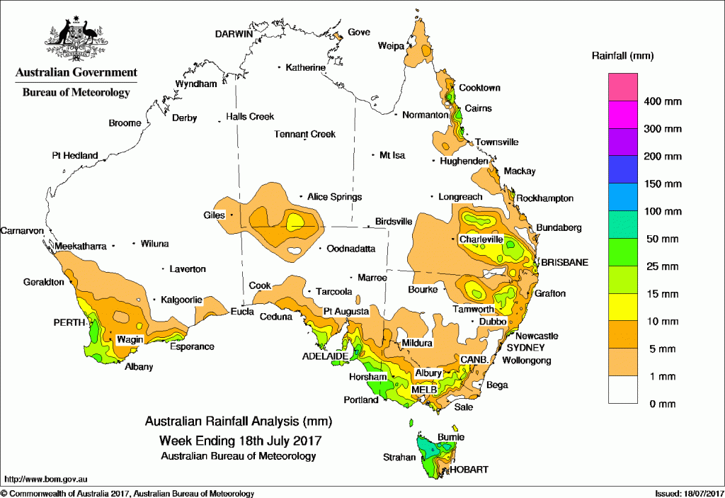
Past seven days: At the start of the week, a cloudband in association with a mid-level trough brought falls to Central Australia while a cold front crossing the south of the country produced mainly light falls in southern Western Australia. The front continued eastward, delivering light to moderate falls to eastern South Australia, western Victoria, and across Tasmania.
During the middle of the week, a mid-level trough and associated surface trough strengthened while moving across northern New South Wales and southern Queensland, resulting in light to moderate falls.
Towards the end of the week, a cold front and associated cloudband connected to a fast moving low pressure system south of the Bight, which brought more rainfall to the South West Land Division of Western Australia. The complex low strengthened as it moved towards the east, with the associated cold front producing widespread rainfall and some thunderstorms along the southeast coast of South Australia, across much of Victoria except Gippsland, and northern Tasmania.
Light rainfall was also reported on Queensland’s North Tropical Coast and the east coast of the Cape York Peninsula during the week, in response to weak onshore flows.
Falls of between 50 and 100 mm were recorded in northern and northwestern Tasmania, parts of the Mount Lofty Ranges in South Australia, and isolated locations in southern Western Australia and coastal Queensland. The highest weekly rainfall total was 90 mm at Huntly in the Lower West District of Western Australia.
Weekly totals in excess of 15 mm were recorded in western and northern Tasmania; the Alpine region; from western Victoria through southeastern South Australia to the Eyre Peninsula; patches of Lower West and Southwest Western Australia; and pockets of northeastern New South Wales, southeastern Queensland and the North Tropical Coast.
Totals of up to 15 mm were recorded surrounding higher falls and in regions of southern and northeastern New South Wales, the Maranoa and Warrego Region of southern Queensland, and central Australia near the South Australia/Northern Territory border.
Little to no rainfall was reported for most of Western Australia away from the South West Land Division and southern coast; central and northeastern South Australia; most of the Northern Territory; central and western New South Wales; and most of Queensland away from the southeast and east coast.
Highest weekly totals
New South Wales and Australian Capital Territory
44 mm Dover Heights (Portland St)*
38 mm Newcastle Nobbys Signal Station
36 mm Nelson Bay (Nelson Head)
Victoria
51 mm Balmoral (Post Office)
44 mm Falls Creek (Rocky Valley)
40 mm Grampians (Mount William)
Queensland
71 mm Daintree Village*
65 mm Ingham Composite
44 mm Allingham Forrest Drive*
Western Australia
90 mm Huntly
49 mm Mount William
47 mm Jarrahdale
South Australia
79 mm Lobethal
77 mm Lobethal
75 mm Hahndorf
Tasmania
86 mm Yolla (Sea View)
78 mm Quamby Bluff
74 mm Sheffield School Farm, Sprent
Northern Territory
14 mm Kulgera
11 mm Yulara Airport
5 mm Watarrka
*This is the highest total rainfall for the week, although observations for the last few days are yet to be received. It is likely that the final total will be slightly higher than this.
More weekly rainfall totals:
- NSW/ACT totals click here
- Vic totals click here
- Qld totals click here
- WA totals click here
- SA totals click here
- Tas totals click here
- NT totals click here
Source: BOM
![]()
HAVE YOUR SAY