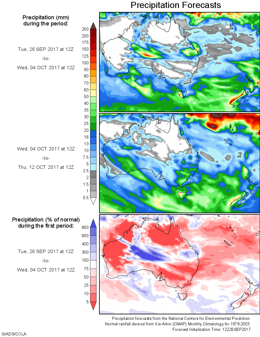
For today’s 14-day rainfall outlook – scroll to bottom of article
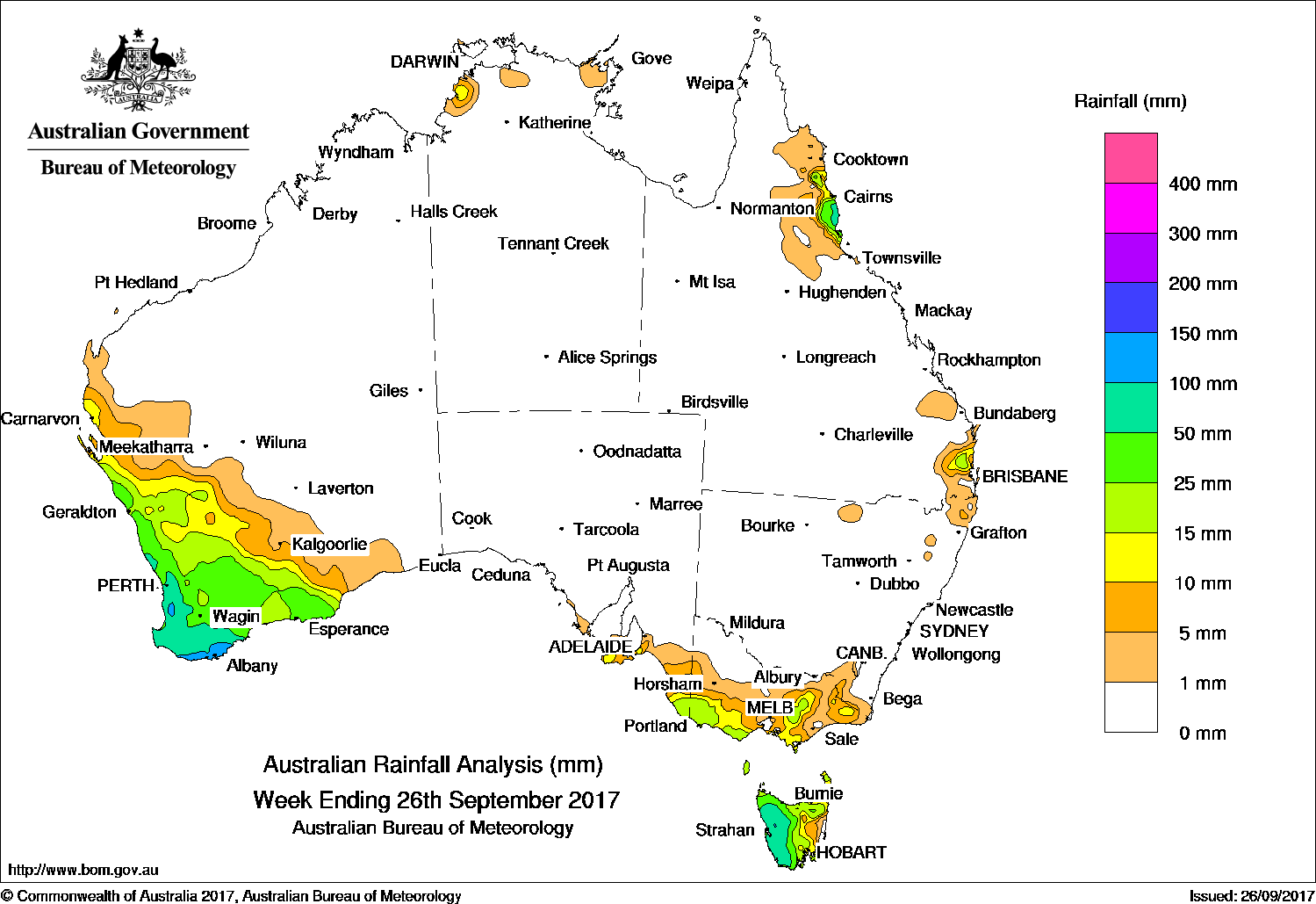
Cold fronts and associated troughs produced thunderstorms with moderate to heavy falls recorded through southern Western Australia. Vigorous cold fronts produced moderate falls over western Tasmania, with light falls through much of the State, extending into Victoria.
Past seven days: At the start of the week, a surface trough and associated cloud band passed over Queensland’s far north and generated moderate falls about the coast and adjacent ranges before moving out into the Coral Sea.
Meanwhile, a weak cold front tracked across southern Australia, generating showers and thunderstorms which brought moderate to heavy rainfall to the southwest of Western Australia. By mid-week, this cold front brushed over Tasmania bringing moderate totals to the State’s northwest and lighter falls throughout much of the State.
A complex low pressure system and associated fronts and surface troughs followed closely behind the first front. This complex system promoted instability while progressing eastward across the Bight during the middle of the week. Cloud bands with embedded showers and thunderstorms led to moderate to heavy rainfall across the South West Land Division of Western Australia, with widespread light falls extending north to the Gascoyne and east to the Southeast Coastal District. Upon reaching the southeast, this system brought western and northern Tasmania light to moderate rainfall, with light falls extending over southern Victoria and far southeastern South Australia during the second half of the week.
Around midweek, a surface trough triggered showers and storms over the southeastern coast of Queensland and the far northeastern coastal district of New South Wales.
During the last days of the week, another strong cold front crossed Western Australia bringing thunderstorms and light to moderate falls across the South West Land Division and southern parts of the State.
Falls of over 50 mm were recorded in western Tasmania, and South West Western Australia, including two totals of 150mm at Mount William and Porongurups. Similar totals were observed in a small part of Queensland’s North Tropical Coast and Tablelands District.
Totals between 15 and 50 mm were recorded in the areas surrounding higher falls, including the Southern Coastal District and the South West Land Division of Western Australia, central and northern Tasmania, and pockets of the Western District of Victoria, far south eastern South Australia and central northeastern Victoria.
Rainfall totals between 5 and 15 mm were recorded across much of Victoria away from the Mallee and South Gippsland, eastern Tasmania, a small section of Queensland’s Southeast Coast, and in the wider areas surrounding heavier falls.
Little or no rainfall was recorded in the north and east of Western Australia, the Northern Territory away from pockets of the coastal Top End, South Australia away from the southeast, nearly all of New South Wales, and most of Queensland away from the far northern tropical coast and the southeast coast.
Highest weekly totals
New South Wales and Australian Capital Territory
12 mm Perisher Valley Aws
12 mm Thredbo Village
8 mm Cabramurra Smhea Aws
Victoria
36 mm Lorne (Mount Cowley)
27 mm Mount Baw Baw
26 mm Multiple locations
Queensland
97 mm Cowley Beach (Defence)
80 mm Bingil Bay
67 mm Babinda Post Office
Western Australia
150 mm Porongurups
150 mm Mount William
139 mm Walpole ForestryWindrush
South Australia
21 mm Nangwarry Forestry Sa Depot
21 mm Inman Valley
17 mm Kalangadoo
Tasmania
134 mm Mount Read
94 mm Lake Margaret Power Station
85 mm Waratah (Mount Road)
Northern Territory
27 mm Labelle Downs
3 mm Nhulunbuy
3 mm Ngayawili
More weekly rainfall totals:
- NSW/ACT totals click here
- Vic totals click here
- Qld totals click here
- WA totals click here
- SA totals click here
- Tas totals click here
- NT totals click here
Source: BOM


HAVE YOUR SAY