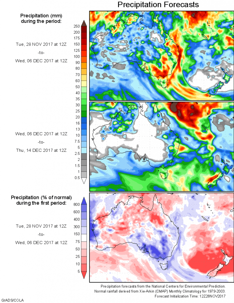
For today’s 14-day rainfall outlook – scroll to bottom of article
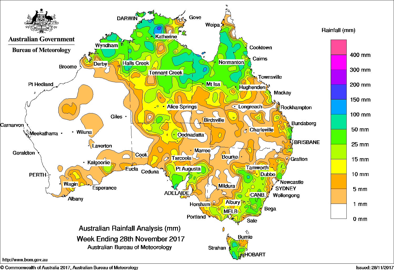
A series of low pressure troughs produced moderate falls across northern Australia. Moderate to locally heavy falls were recorded in southeastern Australia.
The highest weekly total was 187 mm at Nardoo Station in northwest Queensland.
Past seven days: At the beginning of the week, a series of low pressure troughs over northern and western Australia generated thunderstorms in a moist tropical airmass, with moderate falls in the Kimberley, Top End and northern Queensland. A complex low, together with a surface trough over South Australia, produced thunderstorms with moderate falls reported in southern and central parts of the State.
During the middle of the week, broad areas of low pressure stretched across central Western Australia to western Queensland, then south along South Australia’s eastern border. The surface trough combined with an upper level trough, generating thunderstorms and showers with moderate falls Light to moderate showers also fell over parts of southern Victoria, the Alpine region, and Tasmania as the surface trough moved over South Australia to Victoria
In the last part of the week, a weak low pressure system developed over the Goldfields in Western Australia and produced light rainfall in the southern Western Australia. At the same time, a surface trough covering southern parts of the Northern Territory and further south through western Queensland and New South Wales to Tasmania moved slowly eastward. Extensive thunderstorm activity was recorded along much of the trough. Moderate falls were recorded from the northern Kimberley, across the Top End of the Northern Territory, through central Australia, down to southeastern Australia, including Tasmania. As the trough tracked eastwards, further thunderstorms and showers developed with moderate falls recorded in the Gulf Country and in central and eastern New South Wales.
Rainfall totals exceeding 100 mm were recorded in areas of the Top End in the Northern Territory and an area of the Gulf Country in Queensland. The highest weekly total was 187 mm at Nardoo Station in northwest Queensland.
Rainfall totals between 50 mm and 100 mm were recorded in the Kimberley in Western Australia, the northwest to central Top End in the Northern Territory, areas of the Gulf Country, the Cape York Peninsula in Queensland, and scattered locations across southeast Australia.
Rainfall totals between 10 mm and 50 mm were observed in areas surrounding higher falls in the northern Kimberley; most of the Northern Territory except the southwest and southeast; and in the northern half of Queensland and along the State’s east coast. Similar totals were recorded across much of Victoria except the northwest; Tasmania away from the northeast and northwest; much of central and eastern New South Wales; northern, central and southern parts of South Australia; and in small areas of the south coast of southern Western Australia.
Little or no rainfall was recorded in most of Western Australia away from the Kimberley and South Coast; northwest Victoria; the west and northeast of South Australia; western and inland northern New South Wales; southwest and southern parts of Queensland; and in the southwest and southeast of the Northern Territory.
Highest weekly totals
New South Wales and Australian Capital Territory
106 mm Tuggeranong (Isabella Plains)
92 mm Condobolin Retirement Village
72 mm Mount George (Manning River)
Victoria
54 mm Combienbar AWS
53 mm Halls
42 mm St Arnaud (Coonooer Bridge)
Queensland
187 mm Nardoo Station
155 mm Mornington Island Airport, Whyanbeel Valley
Western Australia
90 mm Gibb River
69 mm Mount Elizabeth
63 mm Mount Barnett
South Australia
53 mm Port Lincoln
51 mm Coffin Bay
47 mm Cleve
Tasmania
66 mm Scotts Peak Dam
62 mm Erriba (Jubb Road)
56 mm Lorinna
Northern Territory
179 mm Snowdrop Creek
127 mm Kangaroo Flats (Defence)
125 mm Pinelands
More weekly rainfall totals:
- NSW/ACT totals click here
- Vic totals click here
- Qld totals click here
- WA totals click here
- SA totals click here
- Tas totals click here
- NT totals click here
Source: BOM


HAVE YOUR SAY