For today’s 14-day rainfall outlook – scroll to bottom of article
The remnants of ex-tropical cyclone Nora, embedded on a surface trough, produced moderate falls in the northern tropics. Tropical cyclone Iris formed in the Coral Sea, and is generating moderate to locally heavy falls about the north tropical and central Queensland coasts.
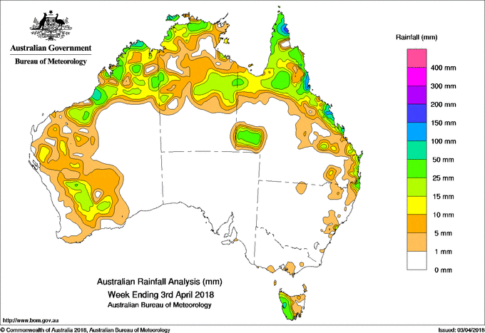
Past seven days: At the beginning of the week, broad areas of low pressure extended across the northern tropics, with the remnants of ex-tropical cyclone Nora lingering about the base of Cape York Peninsula. Showers and storms produced moderate falls in the northern interior and north tropical coast of Queensland, the Gulf Country, about the northern Top End, Carpentaria coast, and central parts of the Northern Territory, and in the north Kimberley coast and Northern Interior in Western Australia. A moist onshore flow generated showers along Queensland’s southeast coast and adjacent inland districts, and in northeastern New South Wales.
From the middle of the week, a surface trough extended from the Pilbara to the Top End while a trough near the west coast in Western Australia moved slowly east. Showers and storms formed along and near the surface troughs, with moderate falls recorded about the Kimberley, east Pilbara and inland Gascoyne along with light to moderate falls in parts of the South West Land Division.
A tropical low in the central Coral Sea, embedded in a surface trough at the start of week, moved slowly northwest and intensified to tropical cyclone Iris well offshore from the north tropical coast in Queensland shortly after tracking south, then southeast at the end of week. Onshore showers associated with Iris produced moderate to locally heavy falls about the north tropical and central coasts of Queensland.
At the end of the week, an inland surface trough triggered storms with moderate rainfall totals in southwest Queensland.
In the south, a trough and associated cloudband produced light to moderate rainfall to the north of the Sydney coast, while a series of weak cold fronts brought moderate falls to western Tasmania throughout the week.
Rainfall totals in excess of 100 mm were recorded in pockets of Queensland’s far northeast, north tropical and central coasts. The highest weekly rainfall total was 197 mm at Hawkins Creek on the north tropical coast of Queensland.
Rainfall totals between 50 mm and 100 mm were recorded about the tip of the Cape York Peninsula, the north tropical and central coasts of Queensland, about the northwest coast of the Top End in the Northern Territory, in small parts of the Kimberley coast in Western Australia, and in the Western District coast in Tasmania.
Rainfall totals between 10 mm and 50 mm were recorded in the north, and pockets of the west of Western Australia; most of the northern half of the Northern Territory; the Gulf Country, Cape York Peninsula, east coast and southwest of Queensland; small areas of northeastern and the central coast of New South Wales, and western Tasmania.
Little or no rainfall was recorded across the interior and southeast and along the west coast of Western Australia, the southern half of the Northern Territory, South Australia, western and southern Queensland, most of New South Wales away from the east coast, Victoria and eastern Tasmania.
Highest weekly totals
New South Wales and Australian Capital Territory
61 mm Wyong (Mount Elliot)
51 mm Murwillumbah
47 mm Green Pigeon (Morning View)
Victoria
7 mm Moe Gippsland Water
6 mm Jindivick
5 mm Wilsons Promontory Lighthouse
Queensland
197 mm Hawkins Creek
170 mm Mount Jukes
166 mm Innisfail, Cardwell Range
Western Australia
70 mm Kalumburu
61 mm Truscott
60 mm Siddins Creek
South Australia
4 mm Parawa (Sharon) Parawa
3 mm Robe
Tasmania
153 mm Mount Read
72 mm Queenstown (South Queenstown)
53 mm Zeehan
Northern Territory
101 mm Pirlangimpi Airport
91 mm Jabiru Airport
54 mm Shoal Bay
More weekly rainfall totals:
- NSW/ACT totals click here
- Vic totals click here
- Qld totals click here
- WA totals click here
- SA totals click here
- Tas totals click here
- NT totals click here
Source: BOM
8 Day rainfall outlook:
HAVE YOUR SAY