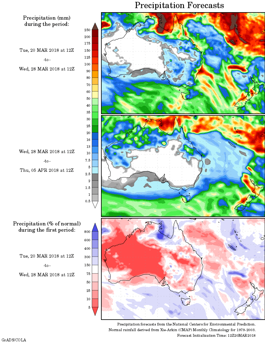
For today’s 14-day rainfall outlook – scroll to bottom of article
Tropical cyclone Marcus produced moderate to heavy falls in the Top End in the Northern Territory; also in the north Kimberley in Western Australia. A cold front produced widespread rainfall and isolated thunderstorms in western Tasmania.
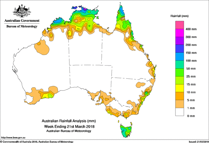
Past seven days: At the beginning of the week, a weak tropical low formed to the north of the Northern Territory within the monsoon trough that extended from the Timor Sea through the Torres Strait into the northern Coral Sea. Showers and storms with moderate falls developed in Arnhem Land in the Northern Territory. Showers also occurred in the far north of the Cape York Peninsula. A moist onshore flow produced showers along the southeast coast of Queensland and about the central coast of New South Wales. A deep trough extended along the southwest coast of Western Australia, with an embedded low pressure system over the far southwest of Western Australia responsible for showers; moderate falls were recorded in the southwest of the State.
From the middle of the week, the low intensified into tropical cyclone Marcus north of Croker Island in the Northern Territory on the 16th. Marcus tracked southwest and first crossed Darwin, and later the north Kimberley of Western Australia as a category 2 system before moving west away from the Western Australia coast towards the end of week. Tropical cyclone Marcus produced extensive shower and thunderstorm activity with moderate to heavy falls across the Top End, and north Kimberley in Western Australia.
Showers and storms produced moderate falls about the east Arnhem coast of the Northern Territory, across the Cape York Peninsula and along the north tropical coast of Queensland, associated with a developing tropical low over the Torres Strait in the latter part of the week.
Further south, a significant cold front crossed Tasmania, bringing a middle level cloud band, widespread rainfall, damaging winds and isolated thunderstorms to much of western Tasmania.
The highest weekly total was 296 mm at Warruwi Airport in the northern Arnhem Land coast in the Northern Territory. Rainfall totals in excess of 150 mm were recorded about the coast of the Top End including the Tiwi Islands.
Rainfall totals between 50 mm and 150 mm were recorded in the north Kimberley in Western Australia, the far north of the Top End in the Northern Territory, the tip of Cape York Peninsula and about the north tropical Queensland coast; also in western and northeastern Tasmania.
Rainfall totals between 10 mm to 50 mm were recorded across the remaining parts of the northern Kimberley, the Top End of the Northern Territory, Cape York Peninsula and north tropical Queensland coast; in southeastern Queensland; in the southwest and south coasts of Western Australia; parts of southeastern South Australia along with an area of the south coast of Victoria, and much of Tasmania.
Little or no rainfall was recorded across Western Australia away from the northern Kimberley and southwest coast, the Northern Territory south of the Top End, most of Queensland except the Cape York Peninsula and the east coast, nearly all of New South Wales apart from some areas along the east coast, Victoria away from the south, South Australia except the southeast, and a small part of southeast Tasmania.
Highest weekly totals
New South Wales and Australian Capital Territory
27 mm Forster – TuncurryRosebank (Repentance Creek)
22 mm Dover Heights (Portland St)
Victoria
25 mm Jindivick
23 mm Portland (Cashmore Airport)
17 mm Wilsons Promontory Lighthouse
Queensland
94 mm Coconut Island
79 mm Moreton Telegraph Station, Horn Island
Western Australia
131 mm Theda
118 mm Kalumburu
50 mm Troughton Island
South Australia
17 mm Parawa (Sharon)
15 mm Mount Gambier Aero
14 mm Parawa (Second Valley Forest), Owen
Tasmania
150 mm Mount Read
114 mm Lake Margaret Power Station, Mount Barrow (South Barrow)
Northern Territory
296 mm Warruwi Airport
212 mm Croker Island Airport
191 mm Gunn Point
More weekly rainfall totals:
- NSW/ACT totals click here
- Vic totals click here
- Qld totals click here
- WA totals click here
- SA totals click here
- Tas totals click here
- NT totals click here
Source: BOM


HAVE YOUR SAY