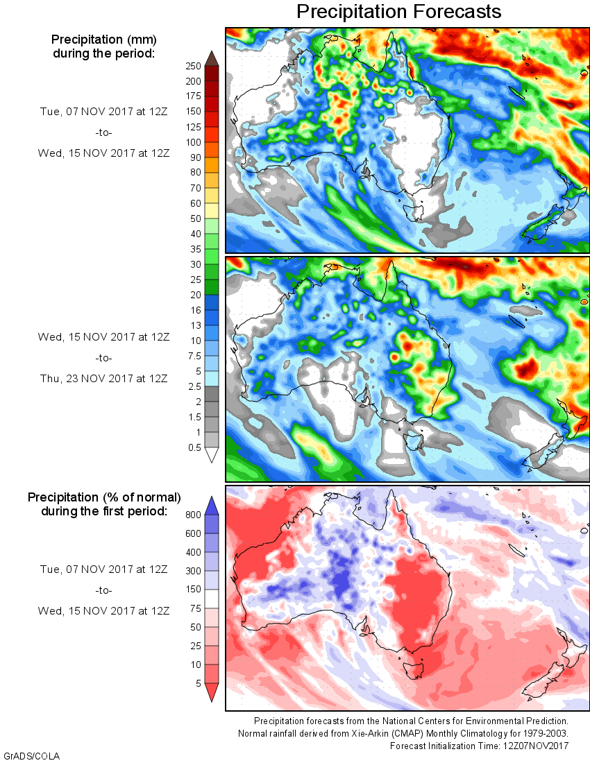
For today’s 14-day rainfall outlook – scroll to bottom of article
Broad surface troughs produced showers and thunderstorms in the north and east of Australia. An intensifying low pressure system tracked across New South Wales, producing moderate to locally heavy falls.
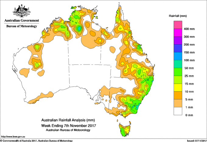
Past seven days: An intensifying low pressure system tracked across New South Wales, producing moderate to locally heavy falls. At the beginning of the week, a broad surface trough stretched across the tropical north and along the east coast of Australia, generating showers and thunderstorms in the Kimberley, Top End in the Northern Territory and in northern and east coast Queensland. In the south, a pair of weak cold fronts tracked across far southeastern Australia and produced a moist onshore flow, with mainly light falls recorded in Tasmania and the eastern half of Victoria.
By the middle of the week, the continent was dominated by broad areas of low pressure as high pressure systems stretched across the Bight. A surface trough extending through western Queensland and into northern New South Wales produced showers, with moderate falls recorded in the Mid North and Central Coast districts. The trough deepened and an embedded low pressure system developed over western New South Wales, generating widespread showers and thunderstorms with moderate to locally heavy falls recorded in Queensland’s southern interior, and in northeastern, southeastern and east coast New South Wales. Isolated thunderstorms formed about the Gulf Country, and in parts of the north of the Northern Territory.
At the end of the week, the intensifying low pressure system tracked over southeastern New South Wales into the Tasman Sea. The associated broad surface trough extended north and west across northeastern New South Wales, southern and western Queensland, through central parts of the Northern Territory and across northern Western Australia. Moderate to locally heavy falls were recorded along the east coast of New South Wales, southeastern Queensland, northwestern parts of the Northern Territory and in parts of the Kimberley, Gascoyne and Pilbara in Western Australia.
Rainfall totals between 50 mm and 100 mm were recorded in the South Coast and pockets of eastern New South Wales, a small area along the central Queensland coast and in parts of the northwest of the Northern Territory. The highest weekly total was 114 mm at Central Tilba (Braeside) in New South Wales.
Rainfall totals between 10 mm and 50 mm were recorded in pockets of the Gascoyne, Pilbara and Kimberley districts of Western Australia, the northwest of the Northern Territory and the Gulf Country. Similar totals were recorded in northern, central and southeastern Queensland; much of eastern and southeastern New South Wales, eastern Victoria and in most of Tasmania apart from the north.
Little or no rainfall was recorded in remaining parts of Western Australia, central and southern parts of the Northern Territory, in the western and central parts of Queensland, western New South Wales, the western half of Victoria, northern Tasmania and almost all of South Australia.
Highest weekly totals
New South Wales and Australian Capital Territory
114 mm Central Tilba (Braeside)
113 mm Ballina Airport AWS
86 mm Woodburn (Cedar St), Smiths Lake (Patsys Flat Road)
Victoria
52 mm Mount Baw Baw
41 mm Combienbar
37 mm Bonang, Combienbar AWS
Queensland
84 mm Mount Charlton
80 mm Daintree Village
62 mm Ballandean Post Office
Western Australia
47 mm Kachana
38 mm Charnley River
27 mm Argyle Aerodrome
South Australia
6 mm Penneshaw, Nangwarry Forestry
5 mm Melton, Parndana
Tasmania
47 mm Mount Read
45 mm Scotts Peak Dam
43 mm Lake Margaret Power Station
Northern Territory
84 mm Pinelands
79 mm Foelsche Headland
78 mm Geriatric Park
More weekly rainfall totals:
- NSW/ACT totals click here
- Vic totals click here
- Qld totals click here
- WA totals click here
- SA totals click here
- Tas totals click here
- NT totals click here
Source: BOM


HAVE YOUR SAY