For today’s 14-day rainfall outlook – scroll to bottom of article
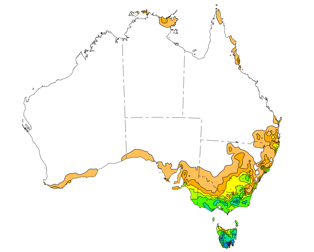
A complex low pressure system and vigorous cold front produced moderate falls across southeastern Australia. Heavy rainfall associated with a strong and gusty southerly airflow resulted in flooding in southeastern Tasmania.
Past seven days: At the beginning of the week, a surface and upper level trough generated showers and moderate falls in southeastern Queensland; also in northern and northeastern New South Wales. Moderate falls were recorded in the north tropical Queensland coast as a result of moist, onshore flow. In the south, a vigorous cold front stretched from New South Wales to eastern Tasmania, with a complex low forming over the Bass Strait region. The associated cloudband had embedded showers and thunderstorms and produced moderate falls in southeastern South Australia, southwest and southern central Victoria, and in northern and western Tasmania.
A complex area of low pressure situated over the eastern Bass Strait and Tasman Sea resulted in a number of low centres. Cloud and thunderstorms circulated around the lows and near a cold front that moved across the Tasman Sea, and produced a vigorous southerly airflow on the western side of the complex low pressure system. This strong, moist and gusty southerly flow generated heavy falls and flooding in parts of southeastern Tasmania, particularly around the Wellington Range and Hobart. Moderate to heavy falls were also recorded across much of the southern half of Tasmania. Moderate falls were recorded in parts southeastern South Australia, from southwestern to central Victoria, as well as elevated areas of the Victorian Alps and Snow Mountains in New South Wales.
As the complex system tracked eastwards, further moderate to locally heavy falls were recorded in much of the eastern half of Victoria, particularly East and West Gipplsand as well as southern coastal parts of the State, northeastern Tasmania, and areas of southeastern New South Wales.
The complex low was located well offshore in the Tasman Sea in the last part of the week, and an onshore southerly airflow on the western side of the complex low produced showers with moderate falls along parts of eastern Victoria, and about the southeast and central coasts of New South Wales. A weak cold front brought light falls to parts of the southern coastline and western Tasmania at the end of the week.
Rainfall totals in excess of 150 mm were recorded in southeastern Tasmania, with areas around the Wellington Range recording falls in excess of 200 mm, including the highest weekly rainfall total of 265 mm at kunanyi/ Mount Wellington.
Rainfall totals in excess of 100 mm were recorded in elevated areas of the Victorian Alps and in parts of southwestern, southern and eastern Tasmania.
Rainfall totals between 50 mm and 100 mm were recorded across much of southern and eastern Tasmania in southwest, southern central and eastern Victoria including much of the Victorian Alps extending into the Snowy Mountains in New South Wales.
Rainfall totals between 10 mm and 50 mm were recorded across southeastern South Australia, most of Victoria except in the northwest, most of Tasmania apart from and area in the northwest, southeastern New South Wales along with pockets of the State’s northeast, central and southeast coasts, and in Queensland’s north tropical coast and southeast.
Little or no rainfall was recorded in Western Australia, the Northern Territory, most of Queensland except the north tropical and southeast coasts, in western, northwestern and parts of northeastern New South Wales away from the coast, and northwestern Victoria.
Highest weekly totals
New South Wales and Australian Capital Territory
115 mm Smiths Lake (Patsys Flat Road)
66 mm Nelson Bay (Nelson Head)
62 mm Bombala AWS
Careys Peak (Barrington Tops)
Victoria
134 mm Club Terrace
104 mm Buchan (Snowy River)
98 mm Reeves Knob
Queensland
65 mm Lady Elliot Island
50 mm Point Lookout
21 mm Cowley Beach (Defence)
Western Australia
12 mm Walpole Forestry
8 mm Barrett Meadows
7 mm Warra Jarra
South Australia
33 mm Nangwarry Forestry
29 mm Parawa (Sharon)
25 mm Mount Gambier Aero
Mount Schank (Jethia), Robe
Tasmania
265 mm kunanyi/ Mount Wellington
240 mm Leslie Vale
207 mm Lachlan (Williams Road)
Northern Territory
12 mm Croker Island Airport
10 mm Milingimbi Airport, Gove Airport
More weekly rainfall totals:
- NSW/ACT totals click here
- Vic totals click here
- Qld totals click here
- WA totals click here
- SA totals click here
- Tas totals click here
- NT totals click here
Source: BOM
-
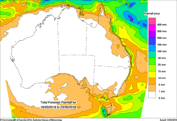
8 Day rainfall forecast:
The “14 day outlook – Scroll to the bottom of article” – is missing – again 🙂
Thanks for your note Paddy, there have been some technical difficulties with the source of our usual weekly chart which have prevented us from publishing it in the last two weeks. In the meantime we have published an 8 day rainfall forecast supplied by the BOM. We hope to have our normal 14 day rainfall forecast back up and running by next week. Kind regards, Editor.