For today’s 14-day rainfall outlook – scroll to bottom of article
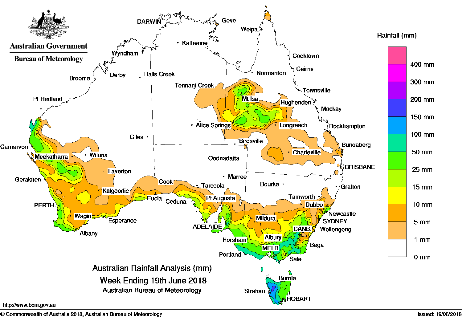
A series of cold fronts produced moderate falls in southeastern Australia, with snow falling in Alpine regions, while a surface trough and cold front generated moderate falls in western and southern Western Australia.
Past seven days: A series of upper level troughs moved eastwards across Queensland, and produced showers, storms and areas of rain over western and northwestern parts of the State. A complex low pressure system passed south of Tasmania while an associated cold front tracked across southern South Australia and Victoria. Moderate falls were recorded in northwestern Tasmania, and elevated areas of the Victorian Alps and Snowy Mountains.
Another complex low pressure system deepened over the east of the Great Australian Bight and, by the middle of the week, moved slowly across the south of Tasmania. The system directed a strong, gusty southerly flow across southeastern Australia. Snow fell across Alpine regions in Victoria, the Snowy Mountains, elevated areas of the Brindabella Ranges in the Australian Capital Territory, and the South West Slopes of New South Wales.
A vigorous westerly airstream with embedded cold fronts affected southeastern Australia during the rest of the week, with a trailing surface trough lingering off the New South Wales coast at the end of the week. Moderate falls were recorded across the southeastern South Australia, most of southern and eastern Victoria, western Tasmania, and elevated areas of the Snowy Mountains and about the central coast in New South Wales.
At the end of the week, a cold front and a pre-frontal trough moved over the west of Western Australia, with an associated cloudband bringing showers and moderate falls to the southwest Pilbara, the Gascoyne, and much of the South West Land Division.
Rainfall totals in excess of 100 mm were recorded in elevated areas of the Victorian Alps and Snowy Mountains, the Mount Lofty Ranges in South Australia, and much of western Tasmania. The highest weekly total was 170 mm at Perisher Valley in the Victorian Alps.
Rainfall totals between 50 mm and 100 mm were recorded about Northwest Cape on the Pilbara coast in Western Australia; far southeast South Australia; southern and northeastern Victoria; the South West Slopes in inland southeastern New South Wales; and the western half of Tasmania.
Rainfall totals between 10 mm and 50 mm were observed in the Gascoyne, parts of the Central Wheat Belt and along much of the southern and western coast of Western Australia; along the central coast and southeast of South Australia; most of Victoria except parts of the northwest; the eastern half of Tasmania; southeastern and the central coast of New South Wales, except some areas on and east of the ranges; and northwestern and western Queensland.
Little or no rainfall was recorded in Western Australia away from the west and southern coast; South Australia away from the coast; most of the Northern Territory; most of the northern half of New South Wales; and much of Queensland except the northwest and western districts.
Highest weekly totals
New South Wales and Australian Capital Territory
116 mm Perisher Valley AWS
85 mm Thredbo Village
77 mm Argalong (Sandy Creek)
Victoria
170 mm Falls Creek
140 mm Lorne (Mount Cowley)
126 mm Wilsons Promontory Lighthouse
Queensland
29 mm Boulia Airport
26 mm Bladensburg
25 mm Winton Airport
Western Australia
96 mm Exmouth Town
72 mm Learmonth Airport
70 mm Karri Valley Resort
South Australia
104 mm Piccadilly (Woodhouse)
102 mm Lenswood
94 mm Uraidla
Tasmania
169 mm Mount Read*, Lake Margaret Dam
134 mm Queenstown (South Queenstown)
Northern Territory
2 mm Epenarra, Alcan Minesite
0.8 mm The Garden
*Mound Read was affected by snow and wind, and the true total is most likely higher
More weekly rainfall totals:
- NSW/ACT totals click here
- Vic totals click here
- Qld totals click here
- WA totals click here
- SA totals click here
- Tas totals click here
- NT totals click here
Source: BOM
Rainfall outlook:
HAVE YOUR SAY