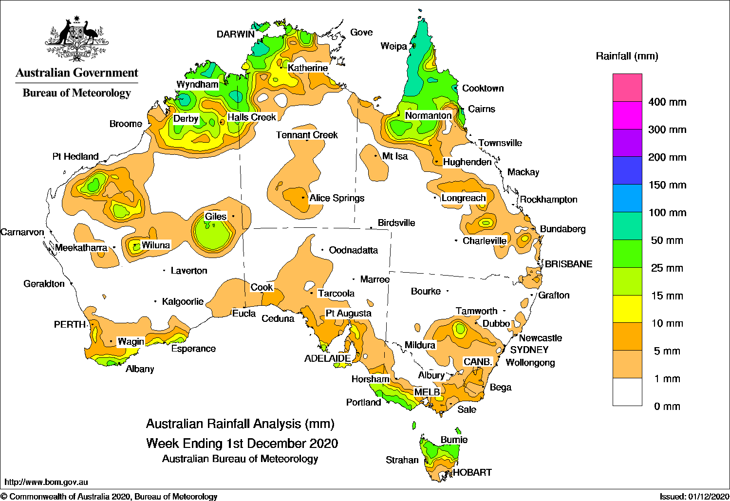
SURFACE troughs triggered thunderstorms across northern Australia, while a cold front produced moderate falls in south-west Victoria and northern Tasmania.
Past seven days: In the first part of the week, surface troughs extended into Western Australia, across the Northern Territory, and from the Gulf Country down through inland Queensland to the south-east of that state. Showers and thunderstorms developed near the troughs, and produced moderate falls over parts of the Gascoyne and Kimberley in Western Australia, the north-west Top End in the Northern Territory, the Gulf Country, parts of the Cape York Peninsula and parts of inland central Queensland. Showers and thunderstorms eased in the north-west but continued across the Cape York Peninsula for the rest of the week.
In the middle of the week, a complex area of surface troughs tracked across the south coast of Western Australia and brought light falls to parts of the south coast of Western Australia. As the system moved into the south-east of Australia, a cold front and low pressure system developed over central Victoria. Moderate falls were recorded over far south-east South Australia, south-west Victoria and the northern half of Tasmania. Much of eastern Victoria and central to south-east New South Wales reported light falls before the system moved offshore. Moist onshore flow brought showers and moderate falls to the north tropical Queensland coast, and thunderstorms developed over the north-west of the continent, with moderate falls in the Kimberley in Western Australia and the north-west Top End in the Northern Territory for the rest of the week.
At the end of the week, a cold front and pre-frontal trough moved over south-west Western Australia and tracked to the state’s south-east, with troughs extending from South Australia to Western Australia, and the Northern territory. Mainly light falls were reported over the south-west of Western Australia, and across large parts of southern South Australia, southern parts of the Northern Territory and an area of far western Victoria. Thunderstorms and moderate falls were reported over the Interior of Western Australia.
Rainfall totals in excess of 50 mm were reported in parts of the Kimberley in Western Australia, the north-west Top End in the Northern Territory, and the far northern Cape York Peninsula. The highest weekly total was 196 mm at Bramwell in the Cape York Peninsula in Queensland.
Rainfall totals between 10 mm and 50 mm were reported across the south coast, and much of the Kimberley, the Gascoyne and Interior districts of Western Australia; much of the north-west Top End in the Northern Territory; the Gulf Country, Cape York Peninsula and north tropical coast of Queensland; and an area of central inland New South Wales. Similar totals were reported in south-west Victoria, the northern half of Tasmania, and south-east South Australia.
Highest weekly totals
New South Wales and Australian Capital Territory
19 mm Condobolin Ag Research Stn
18 mm Condobolin Airport AWS
15 mm Parkers Gap
Victoria
39 mm Cape Nelson Lighthouse
37 mm Portland (Cashmore Airport)
34 mm Nullawarre
Queensland
196 mm Bramwell
109 mm Moreton Telegraph Station
77 mm Cooktown Airport
Western Australia
118 mm Mount Hart Station
80 mm Mount Krauss
74 mm Theda
South Australia
25 mm Mount Gambier Aero
24 mm Lake George
23 mm Nangwarry Forestry Sa Depot
Tasmania
48 mm Memana (Babel Farm)
46 mm Mount Victoria (Una Plain)
45 mm City Of Melbourne BayMount Barrow (South Barrow)
Northern Territory
98 mm Adelaide River Post Office
89 mm Labelle Downs
81 mm Thorak Cemetery
Rainfall outlook
HAVE YOUR SAY