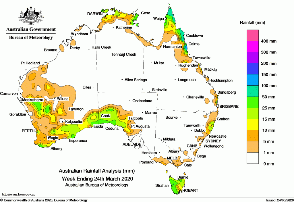
Past seven days: For the week to 24 March 2020, rainfall was recorded in southern and inland western parts of Western Australia, south west South Australia, the coastal Top End of the Northern Territory, Cape York Peninsula and from the north to south east coast of Queensland, about the north east coast of New South Wales, the far south coast of Victoria, and Tasmania. Little to no rainfall was recorded elsewhere.
At the start of the week, a surface trough produced showers and thunderstorms in southeast and central Western Australia. Moist easterly winds also brought showers and thunderstorms along the coastal Top End and Gulf Country in the Northern Territory, and the far northern tip of Cape York Peninsula.
A low pressure system south of Western Australia extended a cold front northwards, with moderate falls recorded over southwest Western Australia. In the east, a moist onshore flow produced showers along the north tropical coast of Queensland, and showers in parts of north eastern New South Wales.
By the middle of the week, the low pressure system south of Western Australia tracked east into the Great Australia Bight, with the associated cold front and pre-frontal trough crossing Tasmania.
Moderate falls were recorded in western Tasmania and light falls were reported in southern central Victoria.
From mid-week, an upper-level disturbance combined with the surface trough and produced a cloudband along the west coast of Western Australia, triggering thunderstorms that produced moderate falls in the southern Gascoyne District.
The cloudband later moved south and east, expanding to produce moderate falls over southern Western Australia and southwestern South Australia.
Showers continued to stream onto York Peninsula, the north tropical coast in Queensland and the eastern Top End of the Northern Territory in the last part of the week.
A south easterly onshore flow over the east coast of Australia also brought low cloud and light showers to coastal Victoria, Tasmania and New South Wales.
Rainfall totals in excess of 100 mm were recorded in the far north tropical coast of Queensland, including the highest weekly total of 152 mm at Allingham Forrest Drive.
Rainfall totals in excess of 50 mm were recorded in the far northern Cape York Peninsula and north tropical coast of Queensland, and a small area in western Tasmania.
Rainfall totals between 10 mm and 50 mm were recorded in the Gascoyne, South West Land Division and southern coastal parts of Western Australia; the coastal parts of the Top End in the Northern Territory; the Cape York Peninsula, north tropical, central and southeast coasts of Queensland; the north east coast of New South Wales; parts of far southern Victoria; most of Tasmania, and south western South Australia.
Highest weekly totals
New South Wales and Australian Capital Territory
52 mm Yarras (Mount Seaview)
38 mm Point Lookout
37 mm Bowra Sugarloaf
Victoria
17 mm Mount Baw Baw
11 mm Balook, Corner Inlet (Yanakie)
Queensland
152 mm South Johnstone Exp Stn
130 mm Lockhart River Airport
118 mm Innisfail
Western Australia
46 mm Eucla
44 mm Northcliffe
42 mm Boolardy
South Australia
30 mm Nullarbor
29 mm Nundroo
26 mm Maralinga
Tasmania
78 mm Lake Margaret Dam
72 mm Mount Read
54 mm Lake Margaret Power Station
Northern Territory
43 mm Shoal Bay
42 mm Groote Eylandt Airport
40 mm Wagait Beach, Gove Airport
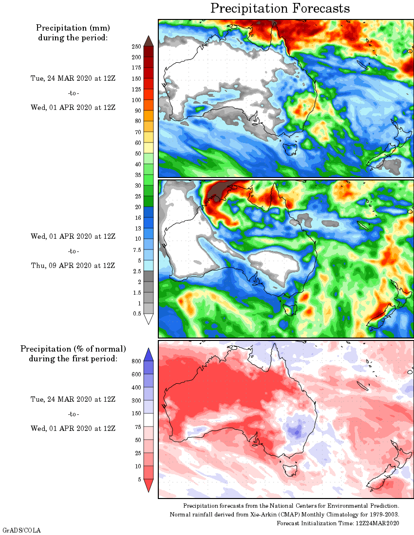
Rainfall outlook