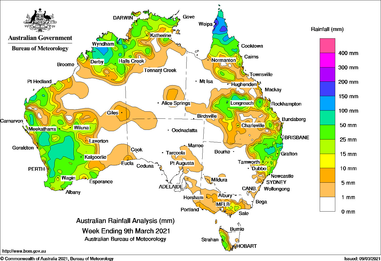
Thunderstorms and showers produced moderate falls across the west of Western Australia; also the northern tropics, while moderate falls were recorded across central to south-east Queensland, north-east New South Wales, and western Tasmania.
Past seven days: At the start of the week, tropical cyclone Niran was located east of Cairns in the Coral Sea. A surface trough extended across the Cape York Peninsula and brought moderate to locally heavy falls to the Cape York Peninsula. Niran moved south-east away from the coast and intensified as it entered Fiji’s area of responsibility.
The surface trough extended from Queensland across the Northern Territory to a low pressure system over the Gascoyne coast in Western Australia, linked to another surface trough along the west coast of Western Australia. Widespread moderate falls were recorded across much of the west of Western Australia as the trough deepened and the embedded low pressure system moved into south-west Western Australia in the first part of the week.
In the east, moist onshore flow brought showers and thunderstorms, with moderate falls recorded in parts of south-east Queensland and north-east New South Wales. In the south, a cold front tracked across Tasmania and brought moderate falls to the state’s west.
From the middle of the week, thunderstorms developed across the northern tropics in the vicinity of surface troughs across northern Australia. Moderate falls were recorded in the Kimberley in Western Australia, the Top End in the Northern Territory, the Cape York Peninsula, and the north tropical coast of Queensland.
During the last part of the week, a surface trough extended from north-west to inland southern Queensland, and triggered thunderstorms and showers through the state’s northern interior, central west, and parts of the Capricornia coast, as well as through inland north-eastern New South Wales. Further showers and thunderstorms developed over central to south-east Queensland and north-eastern New South Wales at the end of the week. In the south, a trough extended towards a cold front tracking south of Victoria and brought light to moderate falls to parts of southern and eastern Victoria.
Rainfall totals in excess of 100 mm were reported in parts of the Kimberley in Western Australia and the northern Cape York Peninsula. The highest weekly total was 199 mm at Archer River Roadhouse in northern Queensland.
Rainfall totals between 50 mm and 100 mm were recorded in the Kimberley, the Gascoyne coast, and parts of the South West Land Division in Western Australia; and some locations in the north-west Top End in the Northern Territory. Similar totals were recorded in the northern Cape York Peninsula, and pockets within central western and south-eastern Queensland and north-eastern New South Wales.
Rainfall totals between 10 mm and 50 mm were recorded across south-west and northern Western Australia; the Top End in the Northern Territory; northern, central and south-east Queensland; north-eastern New South Wales; parts of southern Victoria, and western Tasmania.
Highest weekly totals
New South Wales and Australian Capital Territory
155 mm Tweed Heads Golf Club
139 mm Kingscliff (Woram Place)
127 mm Uki (Tweed River)
Victoria
27 mm Mount Baw Baw
21 mm Kinglake West (Wallaby Creek), Ferny Creek
Queensland
199 mm Archer River Roadhouse
188 mm Scherger RAAF
176 mm Moreton Telegraph Station
Western Australia
137 mm Wandana
134 mm Marradong
117 mm Canterbury
South Australia
13 mm Balaklava (Donaleen Rndsup)
11 mm Tarlee
6 mm Kapunda West (Kaplee), Mount Gambier Aero, Hansborough
Tasmania
75 mm Mount Read
62 mm Queenstown (South Queenstown)
57 mm Strathgordon Village
Northern Territory
133 mm Mccluer Island
105 mm Croker Island Airport
96 mm Milingimbi Airport
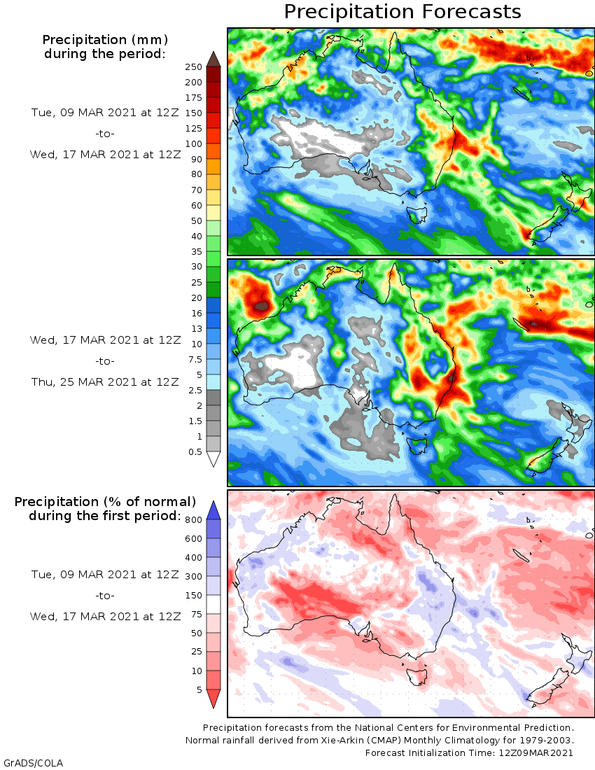
Rainfall outlook
HAVE YOUR SAY