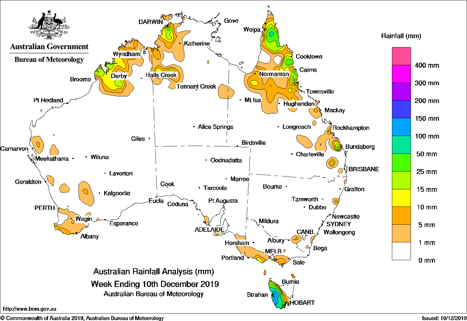
Thunderstorms across far northern Australia generated falls, while a westerly flow produced persistent rainfall in western Tasmania.
Past seven days: At the start of the week, a surface trough extending from the country’s northwest and the Top End, and into northwestern Queensland triggered thunderstorms in the Kimberley in Western Australia, northwestern parts of the Northern Territory, and the Cape York Peninsula in Queensland. A westerly flow produced light rainfall in southern Victoria and moderate falls in western Tasmania.
In the middle of the week, a high pressure system became established in the Bight and dry air dominated most of the country. Rainfall was restricted to the north tropical and southeast Queensland coasts from an onshore flow, whilst the westerly flow continued to produce moderate rainfall in western Tasmania. A weak cold front brought mostly light rainfall over southwest Western Australia.
At the end of the week, most of southern Australia was dry with a high pressure system in the Tasman Sea and another high in the Bight. A surface trough across the tropics produced isolated thunderstorms in the Kimberley, northwestern Northern Territory, and Gulf Country in Queensland. The northern tropical coast in Queensland recorded moderate falls from onshore flow, while isolated thunderstorms brought moderate falls to parts of the Wide Bay and Burnett District in southeast Queensland.
Rainfall totals in excess of 50 mm were recorded in western Tasmania, including the highest weekly total of 233 mm at Mount Read. Rainfall totals between 50 mm and 70 mm were also recorded in isolated spots in the western Kimberley in Western Australia, the Darwin-Daly region in the Northern Territory, and the Cape York Peninsula in Queensland.
Rainfall totals between 10 mm and 50 mm were recorded in the west Kimberley region of Western Australia, in northwestern parts of the Northern Territory, and areas of northern and southeast Queensland. Rainfall totals between 10 mm and 15 mm were recorded in small areas in the southwestern tip in Western Australia; also in southern Victoria.
Little or no rainfall was recorded in most of Western Australia, the Northern Territory, Queensland away from the northern and east coast parts, South Australia away from the southeast, most of Victoria, New South Wales, and the northeastern half of Tasmania.
Highest weekly totals
New South Wales and Australian Capital Territory
21 mm Wittitrin
18 mm Tumbarumba Post Office
5 mm Nashua (Wilsons River)Batemans Bay (Catalina Country
Victoria
25 mm Bundoora (Latrobe University)
16 mm Main Ridge Balook
Queensland
66 mmP iccaninny Plains Station
41 mm Marnhull
38 mm Upper Don AlertArcher River Roadhouse
Western Australia
51 mm Kimbolton
37 mm Theda
35 mm Curtin Aero
South Australia
3 mm Parndana (Turkey Lane)Nangwarry Forestry Sa Depot
2 mm Mount Gambier Aero, Kingston Se
Tasmania
233 mm Mount Read
170 mm Lake Margaret Dam
160 mm Lake St Clair National Park
Northern Territory
56 mm Majestic Orchids
48 mm Fish River
36 mm Humpty Doo, Collard Road


HAVE YOUR SAY