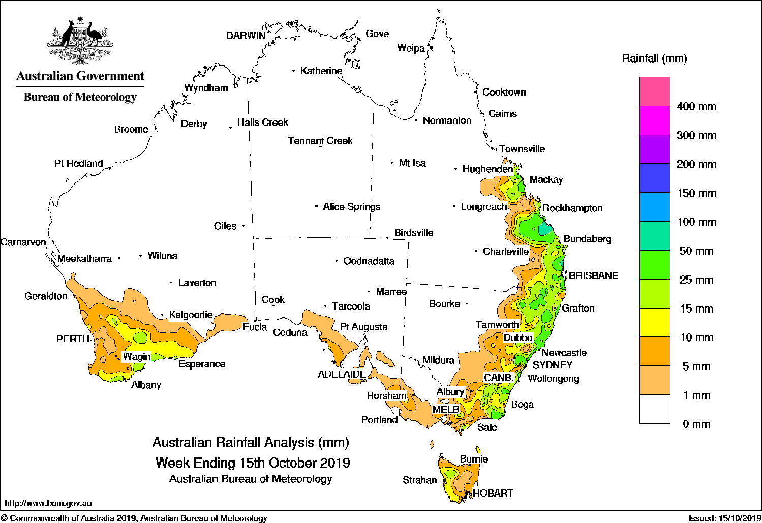
At the start of the week a low pressure system and associated cold front was crossing the Tasman Sea, with showers over southeastern Australia during the 9th.
By the middle of the week a surface trough had formed through eastern Australia, with scattered thunderstorms forming to the east of this trough along the east coast and in Tasmania. Rainfall was locally heavy in parts of Queensland between Bundaberg and Rockhampton, and in parts of the Sunshine Coast. Showers contracted to coastal New South Wales, and cleared by the end of the week.
A cold front linked to a low far over the Southern Ocean crossed the southwest of Western Australia during the middle of the week, bringing widespread light falls in the southwest and isolated heavier showers.
This cold front, and a second front linked to the same low, grazed the southern coast towards the end of the week, bringing light falls to parts of coastal southern Western Australia, South Australia, and western Victoria.
Weekly rainfall totals in excess of 25 mm were recorded in parts of coastal Queensland southward from the Central Coast, with weekly totals in excess of 50 mm in an area between Bundaberg and Rockhampton, and also in a small area of the Sunshine Coast. This included the highest weekly total of 107 mm at Lovandee, near Gladstone. Totals in excess of 25 mm were also reported in parts of eastern New South Wales and the eastern tip of Victoria, in isolated locations west of Esperance, in Western Australia’s Southeast Coastal District, and a few elevated locations in Tasmania and in the Victorian highlands.
Rainfall totals between 5 mm and 25 mm for the week were observed in much of the southern half of Queensland’s east coast; across eastern New South Wales; most of the eastern half of Victoria and a pocket in the west extending from the Wimmera into South Australia’s Upper South East District; parts of the Fleurieu, Yorke, and Eyre peninsulas in South Australia; and across most of Tasmania except the inland; and across most of the southwest of Western Australia.
Little or no rainfall was recorded in Western Australia away from the southwest, most of South Australia, the Northern Territory, Queensland away from the southeast to central coast, central and western New South Wales, and northwestern Victoria.
Highest weekly totals
New South Wales and Australian Capital Territory
69 mmJervis Bay Nsw (Jervis Bay Air
66 mmWooli BeachKurrajong Heights (Bells Line
Victoria
49 mmPoint Hicks (Lighthouse)
40 mmMallacoota
36 mmCann River
Queensland
107 mmLovandee
83 mmGladstone Radar
81 mmTewantin Rsl Park
Western Australia
29 mmHopetoun
28 mmHopetoun North
23 mmGairdnerWarra Jarra
South Australia
12 mmElliston
11 mmYeelanna
10 mmEdithburgh
Tasmania
47 mmKunanyi (Mount Wellington Pinn
43 mmMount Read
20 mmLake Margaret Dam
Northern Territory
0.4 mmNgayawili
0.2 mmManingrida Airport
Rainfall outlook
HAVE YOUR SAY