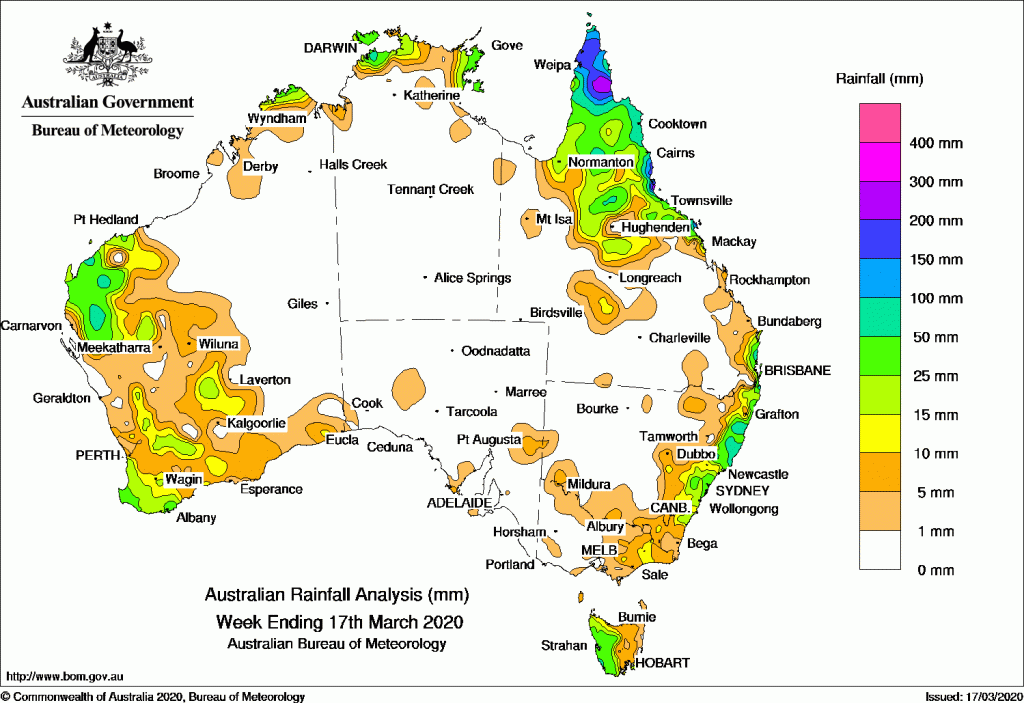
Past seven days: At the start of the week, thunderstorms developed across the tropical north of Queensland, and the eastern Top End of the Northern Territory, associated with a tropical low embedded in the monsoon trough that moved across the York Peninsula to the Coral Sea. Thunderstorms also developed through central Queensland along and near a surface trough that extended from the northwest of Queensland to northeastern New South Wales. A moist, easterly flow combined with the inland trough over eastern Australia and produced showers and light to moderate falls along parts of the southeast Queensland coast and the northeast to central coasts of New South Wales. In the west, a tropical low tracked south across the northwest of Western Australia, bringing moderate rainfall to the west Pilbara and northwest Gascoyne.
Around the middle of the week, a cold front and associated cloudband tracked across southeast Australia. Moderate falls were recorded in western Tasmania and light falls were reported across the eastern half of Victoria. The cold front tracked northeast across New South Wales, and produced light to moderate falls along much of the east coast of New South Wales.
The weakening low pressure system in the west was situated over the far western Gascoyne by mid-week, embedded in a surface trough that extended through inland Western Australia. Showers and thunderstorms produced moderate falls across the western Gascoyne, and light falls across much of the eastern Gascoyne. A surface trough developed along the southwest coast of Western Australia, and moved slowly eastwards, generating showers and thunderstorms in the South West Land Division for the remainder of the week.
Seasonal showers and thunderstorms continued across far northern Australia. The tropical low in the Coral Sea tracked southeast and developed into tropical cyclone Greta on the 15th, well away from the Australian east coast.
Rainfall totals in excess of 200 mm were recorded in far northern parts of the Cape York Peninsula and the north tropical coast of Queensland, including the highest weekly total of 377 mm at Allingham Forrest Drive.
Rainfall totals in excess of 100 mm were recorded across much of the northern Cape York Peninsula and north tropical coast of Queensland.
Rainfall totals in excess of 50 mm were recorded in the western Gascoyne in Western Australia, around the Darwin-Daly District in the Northern Territory, parts of far northern Queensland, pockets of east coast New South Wales, and a small area of southwestern Tasmania.
Rainfall totals between 10 mm and 50 mm were recorded in the northern Kimberley, Gascoyne and South West Land Division in Western Australia, the coastal parts of the Top End in the Northern Territory, northern and southeast Queensland, east coast New South Wales, parts of eastern Victoria, and most of western Tasmania.
Highest weekly totals
New South Wales and Australian Capital Territory
145 mm Careys Peak (Barrington Tops), Mooral Creek (The Den)
117 mm Meldrum (Coolawarrah)
Victoria
38 mm Mount Baw Baw
20 mm Lakes Entrance (Eastern Beach)
15 mm Bruthen (Post Office)
Queensland
377 mm Allingham Forrest Drive
328 mm Victoria Sugar Mill
289 mm Ingham Composite
Western Australia
67 mm Lyons River Airstrip
66 mm Thevenard Island
57 mm Nunile
South Australia
14 mm Tailem Bend
10 mm Coffin Bay (Point Avoid)
7 mm Yunta (Panaramitee)
Tasmania
66 mm Mount Read
56 mm Scotts Peak Dam
44 mm Strahan Aerodrome, Strahan (Andrew Street)
Northern Territory
146 mm Mcminns Lagoon
100 mm Humpty Doo Collard Road
81 mm Middle Point
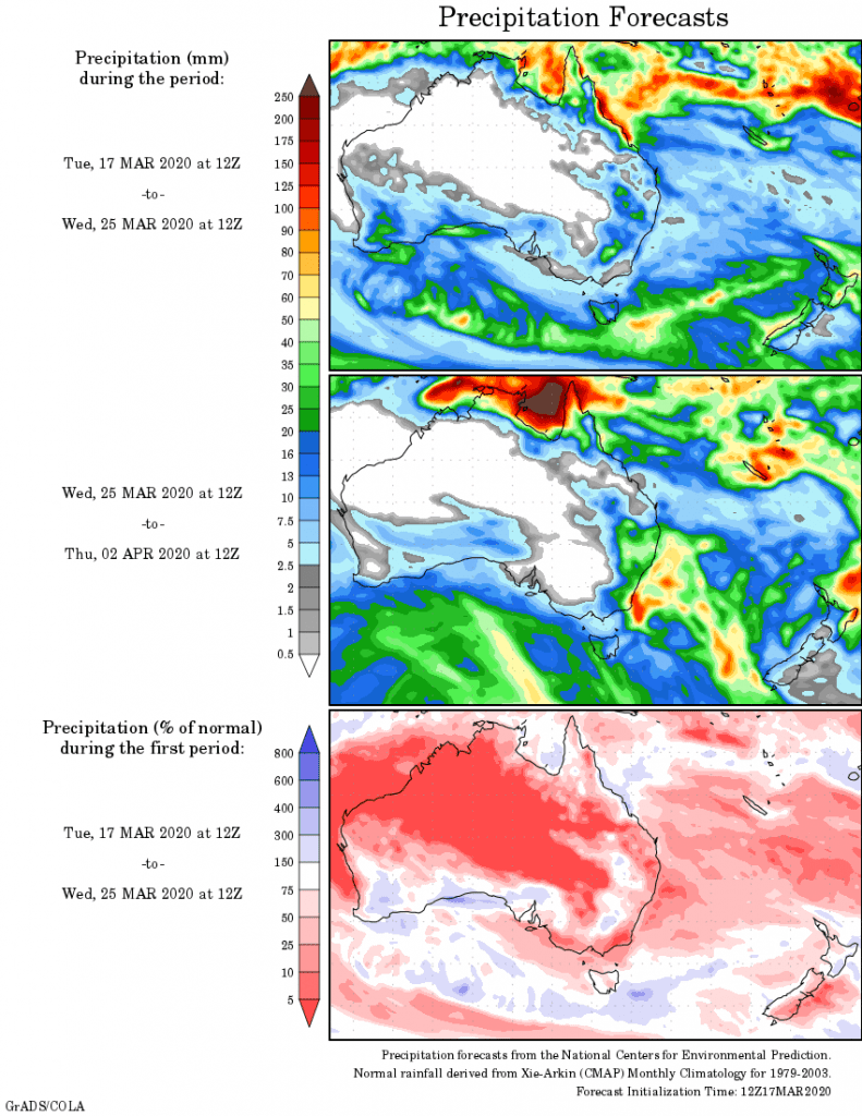
Rainfall outlook


HAVE YOUR SAY