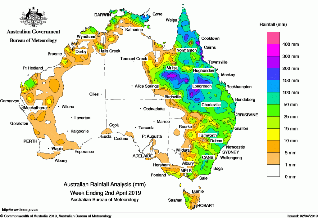
Ex-tropical cyclone Trevor produced heavy falls from western to central Queensland, with heavy falls also over the eastern Top End, while a cold front and pre-frontal trough tracked across southeast Australia, and brought moderate falls to much of eastern Australia.
Past seven days: In the first half of the week, broad surface troughs extended along the west coast, through the Northern Territory, to the remnants of ex-tropical cyclone Trevor situated along the Northern Territory–Queensland border, and through central to southeast Queensland. Moderate falls were recorded in the western Pilbara and parts of the Kimberley in Western Australia and the Top End in the Northern Territory. Moderate to heavy falls were recorded from western to central Queensland, extending into southern parts of the State; also about Arnhem Land in the Northern Territory, Cape York Peninsula, and the northern tropics of Queensland. As the remnants of ex-tropical cyclone Trevor moved eastwards though central Queensland, further moderate falls were recorded in the centre and east of the State.
In the second half of the week, further south, a cold front tracked across southeast Australia, and combined with the surface trough through eastern Australia and remnants of the tropical low. These features produced widespread moderate falls in the eastern halves of Queensland, New South Wales and Victoria, and in western Tasmania. Falls contracted towards the east coast and Cape York Peninsula, with the end of the week dry for most of eastern Australia.
As the low pressure troughs shifted off the mainland, showers and storms contracted to the far northern parts of the Northern Territory, Cape York Peninsula, and northeastern Queensland at the end of the week. Isolated light falls were also recorded along the west coast of Western Australia, parts of southwestern and southern Victoria, and western Tasmania.
Rainfall totals in excess of 200 mm were recorded in parts of Queensland’s central interior, northwest and north tropical coast. The highest weekly total was 313 mm at Gairloch on Queensland’s northern tropical coast.
Rainfall totals in excess of 100 mm were recorded in parts of Arnhem Land in the Northern Territory; parts of the Cape York Peninsula and Queensland’s northern interior and north tropical coast, a large area from western to central Queensland, along with isolated pockets in the southeastern quarter of the State; and at some locations in the Hunter and Central Tablelands districts in New South Wales.
Rainfall totals in excess of 50 mm were recorded across the coast in the central and eastern Top End in the Northern Territory; large areas of northern, western and central Queensland, extending into southern districts; parts of the North and Central West Slopes and Hunter districts in New South Wales; elevated areas of the Alps and elevated parts of southeastern New South Wales; and at some locations in western Tasmania.
Rainfall totals between 10 mm and 50 mm were recorded in parts of the Kimberley and Pilbara in Western Australia, the northern Top End in the Northern Territory, most remaining areas of Queensland except the far southwest and parts of the Gulf Country, central to eastern New South Wales, southern and eastern Victoria, a small area in the far southeast of South Australia, and western Tasmania.
Little or no rainfall was recorded in remaining parts of Western Australia, most of the Northern Territory, most of South Australia, northwestern to northern country Victoria, western New South Wales, and the far southwest of Queensland and parts of the Gulf Country.
Highest weekly totals
New South Wales and Australian Capital Territory
129 mm Cassilis (Thistledale)
125 mm Blackville (Krui Vale)
121 mm Cassilis (Dalkeith)
Victoria
63 mm Ferny Creek
55 mm Mount Baw Baw,Ovens River at Eurobin
Queensland
324 mm Gairloch
297 mm Tully Sugar Mill, Victoria Sugar Mill
Western Australia
59 mm Thevenard Island, Country Downs
42 mm Winderie Airstrip
South Australia
10 mm Mount Gambier AeroRobe
9 mm Mount Schank (Jethia), Victor Harbor (Encounter Bay)
Tasmania
60 mm Mount Read
56 mm Lake Margaret Power Station
48 mm Queenstown (South Queenstown)
Northern Territory
152 mm Gove Airport
132 mm Ngayawili
131 mm Croker Island Airport
Source: BOM


HAVE YOUR SAY