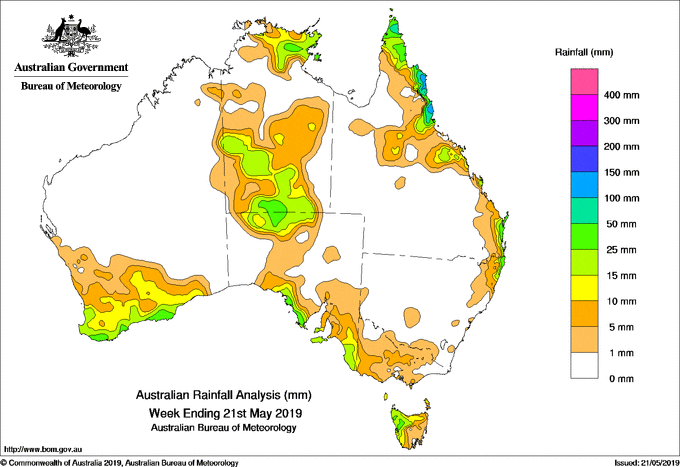
FOR the week to 21 May 2019, rainfall was recorded in the south of Western Australia; the eastern half of the Top End and the southern half of the Northern Territory; the far north and coastal South Australia; southwestern and central Victoria; western and northern Tasmania; far northeastern New South Wales and along the east coast and northern interior of Queensland.
Past seven days: At the start of the week, ex-tropical cyclone Ann was located northeast of Cairns, and tracked west towards Queensland’s north tropical coast. The system crossed the coast near Lockhart River, and brought showers and rain with heavy falls to the Cape York Peninsula and North Tropical Coast districts. Light falls were recorded across parts of the northern interior and central Queensland due to a surface trough that extended south from the tropical low through inland Queensland. The system moved into the Gulf of Carpentaria and brought showers and thunderstorms to Arnhem Land in the Northern Territory from early in the week.
Onshore flow brought light falls to southeastern Queensland and northeastern New South Wales throughout the week.
In the west, a cold front and pre-frontal trough generated an extensive cloudband that tracked across southwest Western Australia, generating light to moderate falls in the South West Land Division and southern parts of the State during the first part of the week.
By the middle of the week, the cloudband continued to track eastwards, with a surface trough extending north into Central Australia and generating thunderstorms and moderate falls in the southern half of the Northern Territory and northern South Australia. The cloudband also spiralled south into a low pressure centre over the Great Australian Bight. Widespread thunderstorm activity associated with the passage of the surface trough brought moderate falls to parts of the West Coast District, the Eyre and Yorke peninsulas, Kangaroo Island, and the southeast of South Australia. Light falls were reported in southwestern Victoria, while showers and thunderstorms produced moderate falls in western and northern Tasmania at the end of the week.
Rainfall totals in excess of 100 mm were recorded in far northeastern Queensland, including the highest weekly total of 164 mm at Tully Sugar Mill.
Rainfall totals in excess of 50 mm were recorded in small areas of the Upper North Coast in New South Wales, and in areas along the northeast coast of Queensland from the northern Cape York Peninsula south to around Innisfail.
Rainfall totals between 10 mm and 50 mm were recorded in southwest and southern Western Australia, in the eastern half of the Top End and southern half of the Northern Territory, in northern and coastal South Australia, western Tasmania, northeastern New South Wales and along the east coast and northern interior of Queensland. Scattered locations in Victoria also observed weekly totals in excess of 10 mm.
Little or no rainfall was recorded in remaining parts of Western Australia, the Northern Territory and South Australia; northwest and eastern Victoria; east coast and southeastern Tasmania; most of New South Wales except about the northeast coast; and Queensland away from the east coast and northern interior of the State.
Highest weekly totals
New South Wales
65mm Nashua (Wilsons River)
52mm Wooli Beach
50mm Ballina Airport AWS
Victoria
13mm Apsley (Post Office)
Cape Schanck
Trentham Strathbogie
Queensland
164mm Tully Sugar Mill
120mm Cooktown Airport
118mm Hazelmere
Western Australia
46mm North Walpole
43mm Telina Downs
36mm Gairdner
South Australia
48mm Coulta
48mm Mount Hope (Fairview)
47mm Kingscote
Tasmania
56mm Mount Read
27mm Savage River Mine
25mm Queenstown (South Queenstown)
25mm Luncheon Hill (Forestry)
Northern Territory
35mm Warramunga
33mm Kulgera
30mm Alice Springs Desert Park
Rainfall outlook
HAVE YOUR SAY