Tropical cyclone Esther produced heavy falls about the Gulf Coast in Queensland and the Northern Territory, while a trough brought heavy falls over the east coast, central, and southern inland Queensland.
Past seven days: In the first part of the week, showers and thunderstorms developed over northern Australia, as well as along the west coast of Western Australia and through central Queensland, due to a humid and unstable air mass. In the southeast, a slow-moving low pressure system over the Tasman Sea and associated cloudband generated widespread thunderstorms and moderate falls in eastern New South Wales, southern Victoria, and northern Tasmania.
An active monsoon trough established across the northern Gulf of Carpentaria, northern Cape York Peninsula, and northern Coral Sea from early in the week, with a surface trough extending across central parts of the Northern Territory and across northwest Western Australia. Widespread thunderstorms and showers produced moderate falls about the Pilbara, Gascoyne, and Kimberley in Western Australia, the Top End in the Northern Territory, and across northern Queensland.
A tropical low, linked to the monsoon trough, developed in the Gulf of Carpentaria and became tropical cyclone Esther. Large areas of convective cloud and thunderstorms produced moderate to locally heavy falls across Queensland’s northern tropics during the middle of the week, with heavy falls about the southern Gulf Coast following mid-week as Esther crossed the coast near the Northern Territory–Queensland border on 24 February.
Further south, a surface trough extended through the interior of Queensland during the second half of the week, with a strong upper-level trough enhancing showers and storms through southern inland to Capricornia coast Queensland.
In Western Australia a slow-moving west coast trough produced showers and thunderstorms over the South West Land Division and adjacent central interior of that State during the second half of the week.
Rainfall totals in excess of 200 mm were recorded in parts of the Gulf Country, pockets of Queensland’s east coast, and southern inland Queensland. The highest weekly total was 431 mm at Mount Jukes, to the north of Mackay on the central Queensland coast.
Rainfall totals in excess of 100 mm were recorded in parts of the coastal Top End, Gulf Country, Cape York Peninsula, and along parts of Queensland’s east coast and southern interior.
Rainfall totals in excess of 50 mm were recorded in the South West, southern Gascoyne, and Kimberley districts in Western Australia; the northern Top End; Gulf Country, northern tropics and pockets of the east coast of Queensland, and across the southern and central interior of that State.
Rainfall totals between 10 mm and 50 mm were recorded in western and northern Western Australia, the northern third of the Northern Territory, most of Queensland away from the Channel Country District, northern and eastern New South Wales, the southern half of Victoria and the far east, and most of Tasmania except in the northwest and southeast.
Little to no rainfall was recorded in areas away from the west, north and east.
Highest weekly totals
New South Wales and Australian Capital Territory
114 mm Yarras (Mount Seaview)
103 mm Minnie Water (Pump Shed)
97 mm Bellwood (Nambucca Heads (Namb
Victoria
64 mm Mount Baw Baw
61 mm Lake Tyers
58 mm Ferny Creek
Queensland
431 mm Mount Jukes
402 mm Rollingstone
366 mm Mornington Island Airport
Western Australia
112 mm Port Smith
89 mm Drysdale River Station
82 mm Yampi Sound (Defence)
South Australia
14 mm Nangwarry Forestry SA Depot
11 mm Mount Gambier Aero
7 mm Coonawarra
Tasmania
80 mm Swan Island
69 mm City Of Melbourne Bay
68 mm Mount Barrow (South Barrow), Memana (Babel Farm)
Northern Territory
247 mm Centre Island
205 mm King Ash Bay
198 mm Gunn Point
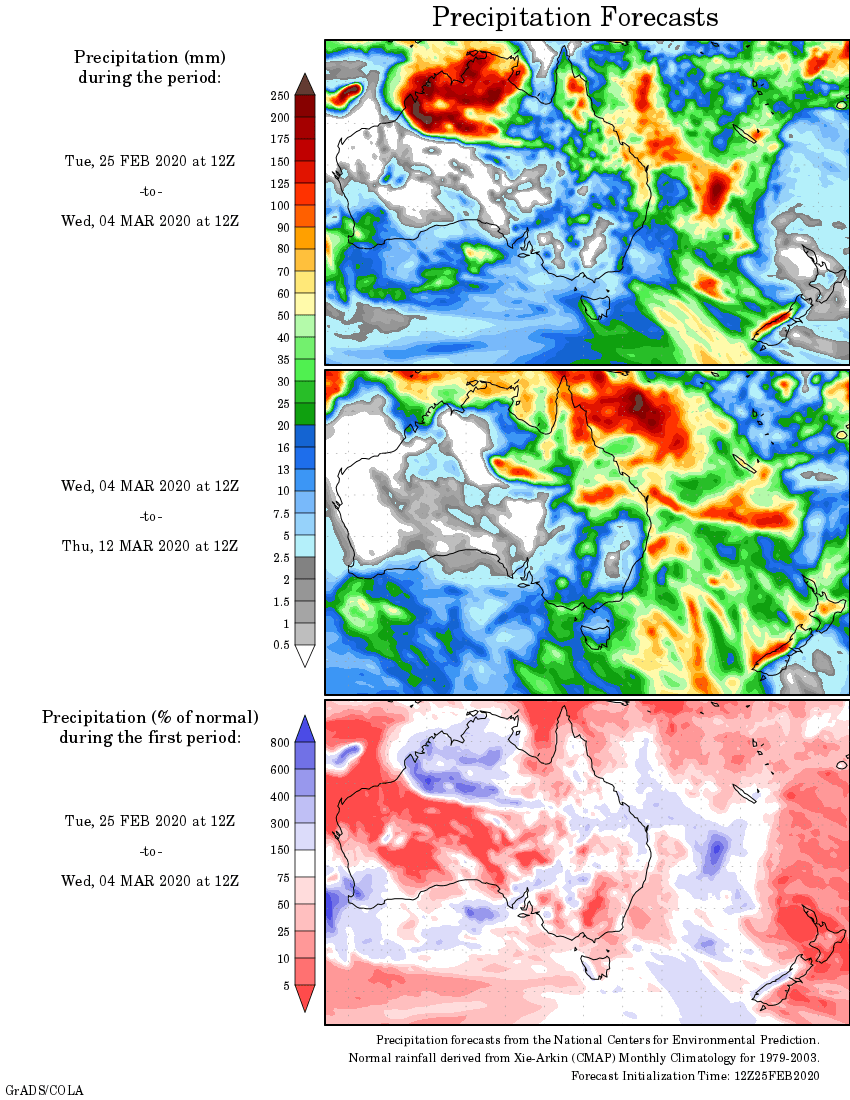
Rainfall outlook
HAVE YOUR SAY