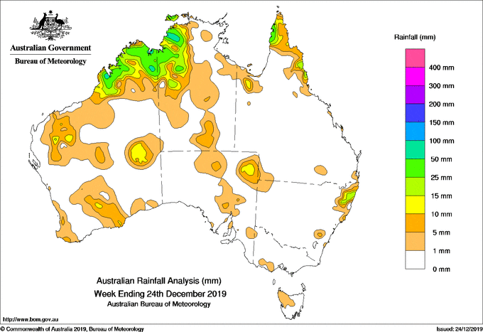
FOR the week to 24 December 2019, rainfall was recorded in the Kimberley, parts of the Pilbara and Gascoyne, Southern Interior, and South West Land Division in Western Australia; in the north west, and central and southern parts of the Northern Territory; in the Cape York Peninsula, north tropical coast and Gulf Country in Queensland; north eastern New South Wales; in areas of the agricultural and northern districts of South Australia; part of south west Victoria, and northwest Tasmania.
Little or no rainfall was recorded in the remaining parts of the country.
In the first half of the week, surface troughs extended from along inland parts of the west coast, across the northwest, through the Northern Territory, and down through inland Queensland.
A high pressure system located over the Great Australia Bight extended a ridge along the northeast coast of Queensland.
Thunderstorms and showers developed over the Kimberley in WA, the north west of the NT, and also along the north east tropical coast of Queensland due to a moist onshore flow.
A weak cold front and pre-frontal trough tracked across south west WA, and generated light falls in the far southwest of that state.
In the second half of the week, surface troughs extended along inland parts of the west coast and across northern Australia, with weak embedded low pressure systems situated over the north west Top End and inland north of WA.
Showers and thunderstorms produced moderate falls in the Kimberley and north west Top End of the NT, and also about the northern Cape York Peninsula in Queensland.
Showers and lighter falls were reported over inland areas of the Pilbara and Gascoyne, and an area of the South West Land Division.
Showers and thunderstorms developed over north eastern NSW at the end of the week, generating light to moderate falls in the area.
Light to moderate falls were also reported over parts of southeast South Australia, parts of western Victoria, and northwest Tasmania.
Surface troughs also extended through parts of Central Australia, and through the interior of WA later in the week. Isolated showers and storms developed over southern parts of the NT, areas of the agricultural and Flinders districts in SA, and interior parts of WA.
Rainfall totals in excess of 50mm were recorded small areas in the Kimberley in WA, the north west of the NT, and in the far north west Cape York Peninsula in Queensland.
The highest weekly total was 68mm at Douglas River Research Farm in the north west of the NT.
Rainfall totals between 10mm and 50mm were recorded in WA in an area around the south coast, central interior, northern Gascoyne and the Kimberley; the north west of the NT; the far northern Cape York Peninsula, an area of the Gulf Country, and north tropical coast of Queensland; north eastern NSW, and in a small area of north east SA.
Light falls of less than 10mm were reported in southwest WA, some parts of the agricultural districts and south east of SA, part of south west Victoria, north west Tasmania, areas in the southern parts of the NT, and isolated areas of eastern NSW and south east Queensland.
Source: BOM
HAVE YOUR SAY