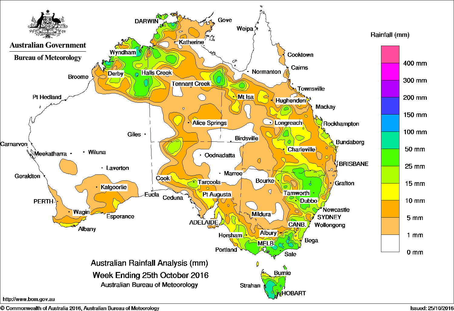
The Kimberley, northern NSW and Southern Victoria received the best falls of the past week.
Past seven days: At the start of the week, a broad surface trough extended across northern Western Australia and the Top End in the Northern Territory, generating thunderstorms and moderate rainfall totals in parts of the Kimberley, Pilbara, and northern interior of Western Australia, and in the northwestern parts of the Northern Territory. In the south, a cold front brushed the south coast of Western Australia, and intensified as it tracked across South Australia. Widespread light to moderate rainfall totals were recorded across southern Western Australia, South Australia and southern Victoria.
In the middle of the week, an extensive cloudband stretched from the Northern Territory to southeast of Tasmania. Moderate falls were recorded in the pastoral districts, southern and southeastern parts of South Australia, southwestern Victoria, large parts of eastern New South Wales and Tasmania as the cold front tracked across the southeast. Thunderstorms and showers associated with an extensive cloudband were recorded across northern Australia with moderate falls in the Kimberley, the Top End and about Alice Springs in the Northern Territory, and the Gulf Country.
At the end of the period, the trough extending from the low pressure system in the Tasman Sea produced moderate rainfall totals in eastern Victoria and parts of Tasmania. Another trough extending along the east coast of Queensland generated widespread light to moderate falls in central and southern Queensland, and northeastern New South Wales.
50-100mm: Small areas in the east and northwest of the Northern Territory, parts of the Kimberley region in Western Australia; pockets of East, West and South Gippsland; southwestern Tasmania and in a small area of northern New South Wales. The highest weekly total was 133 mm at Mount Baw Baw in Victoria.
10-50mm: The far north and along the south coast of Western Australia; the northwest, the east and southern parts of the Northern Territory; an area in the northwest and in the southern and southeastern parts of South Australia; most of Victoria except the central north and northwest and in northwestern Tasmania. Similar totals were recorded in eastern and northeastern New South Wales, and in southern, central, northwestern and parts of eastern Queensland.
Little or no rainfall: Remaining parts of Western Australia; in western and northeastern parts of South Australia; in the southwest, southeast and northeast of the Northern Territory, in southwestern and northern Queensland, western New South Wales and northwestern and northern central Victoria.
Highest weekly totals list
New South Wales and Australian Capital Territory
87 mm Murrurundi (Haydon Street)
65 mm Thredbo Village
62 mm Narrabri
Victoria
133 mm Mount Baw Baw
95 mm Bullumwaal
73 mm Reeves Knob
Queensland
49 mm Lochinvar
41 mm Mt Douglas
34 mm Nanango Wills St
Western Australia
128 mm Diggers Rest
75 mm Moola Bulla Airstrip
61 mm Halls Creek Airport
South Australia
44 mm Mallala
26 mm Mount Compass
25 mm Meadows, Kangarilla (Saddlebags)
Tasmania
67 mm Mount Victoria (Una Plain)
60 mm Warra
57 mm Wayatinah (Saltas)
Northern Territory
125 mm Charles Point
60 mm Point Stuart
49 mm Darwin River Dam
More weekly rainfall totals:
- NSW/ACT totals click here
- Vic totals click here
- Qld totals click here
- WA totals click here
- SA totals click here
- Tas totals click here
- NT totals click here
Source: BOM
HAVE YOUR SAY