AS crop data from satellite imagery reaches mindboggling levels and the tools to access it become much simpler to use, the way is opening up for an increasing number of farmers to make the move into space-age crop management.
Satellite imagery now has the capacity to provide farmers with time-critical data on such things as soil constraints, fertiliser requirements, crop performance, crop health and weed management. Most significantly, it can pre-empt problems long before they become apparent to the naked eye.
Tim Neale
Speaking via video-link to GRDC Grains Research Updates, DataFarming managing director Tim Neale said access to critical farm data was increasing every day through advanced technologies such as satellite imagery, harvester yield monitoring and mapping, and greater connectivity between farm machinery.
As an example of the ready access to real-time crop performance information, Mr Neale said his company had created a simple web application that gathered data from satellites, providing a “bird’s-eye view” of what was going on in the field.
“It is detecting things our eyes can’t see. It measures into the near-infrared spectrum. So, it detects problems in the crop much earlier. That’s why it is a valuable tool above and beyond normal crop checking,” he said.
Mr Neale said while a farmer conducting on ground paddock inspection would pick up gradational change, satellite imagery instantly highlighted the differences within a paddock.
This is illustrated in Figure 1 below where the areas of healthy crop represented by the blue areas are instantly distinguishable from the unhealthy crop represented by the red areas.
“It is a reasonably fine resolution of 10 metres by 10 metres on the ground. It is a really good starting point into the journey. It really helps you pinpoint the different areas in the paddock to go and check,” he said.
“After ground truthing, you can quickly convert it into a zone map which splits the image into three polygons – high, medium and low – which you can put straight into a machine and go and apply it.”
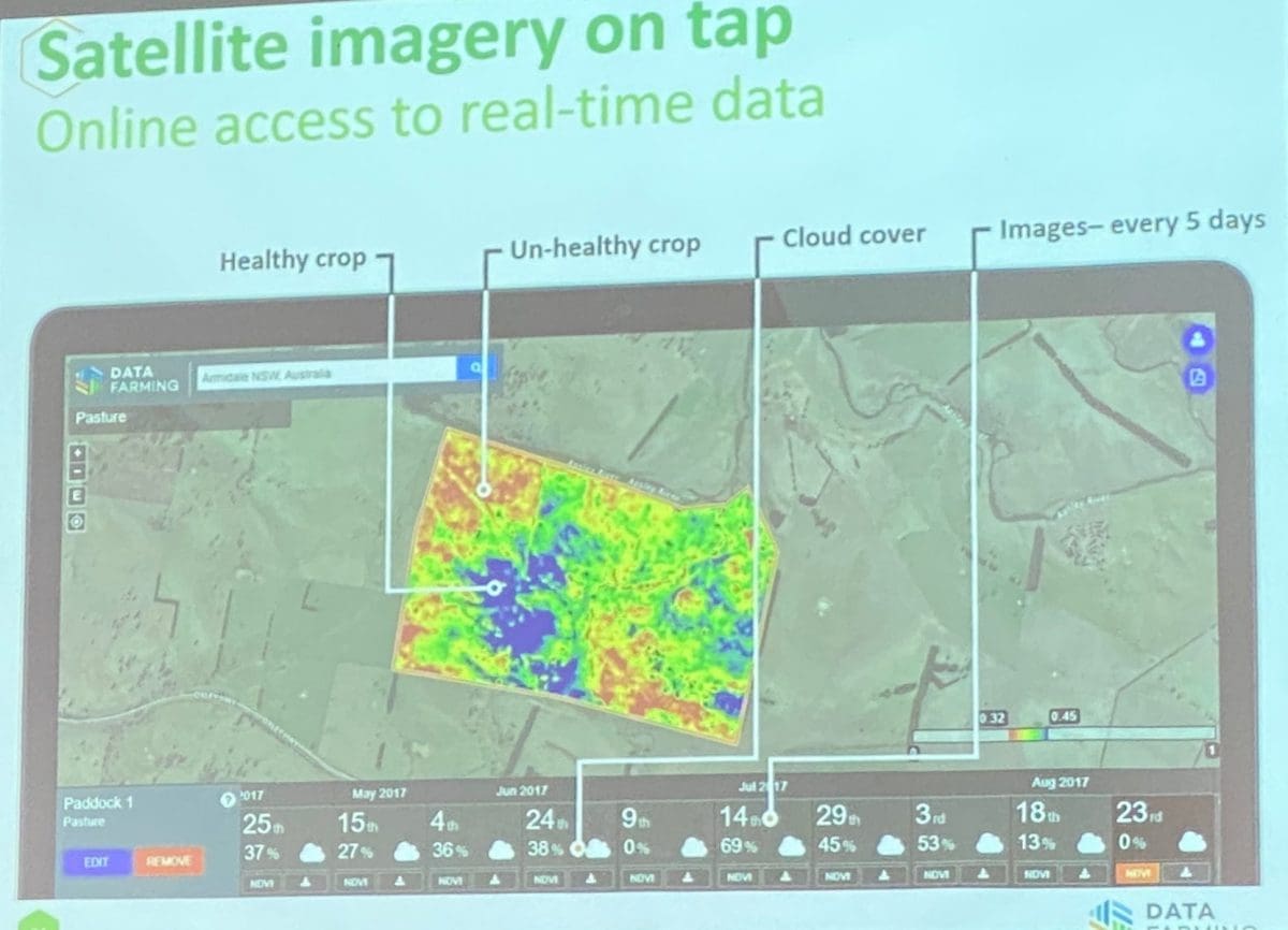
Figure 1: Blue areas represent healthy crop; red areas unhealthy crop.
Mr Neale said another example of the potential application of satellite data was research he was conducting into whether the technology could give early warning of lodging in crops like sorghum.
“We spent time looking at lodged and non-lodged crops. We were able to detect the early signs of lodging about six to eight weeks before the lodging event,” he said.
“It is early days, but it shows that we can detect stresses in plants very early on before they show the typical signs of lodging. Whilst it might be too late by then, getting some early warning signs must help with spray out, timing of desiccation and hotspots that might need to be checked.”
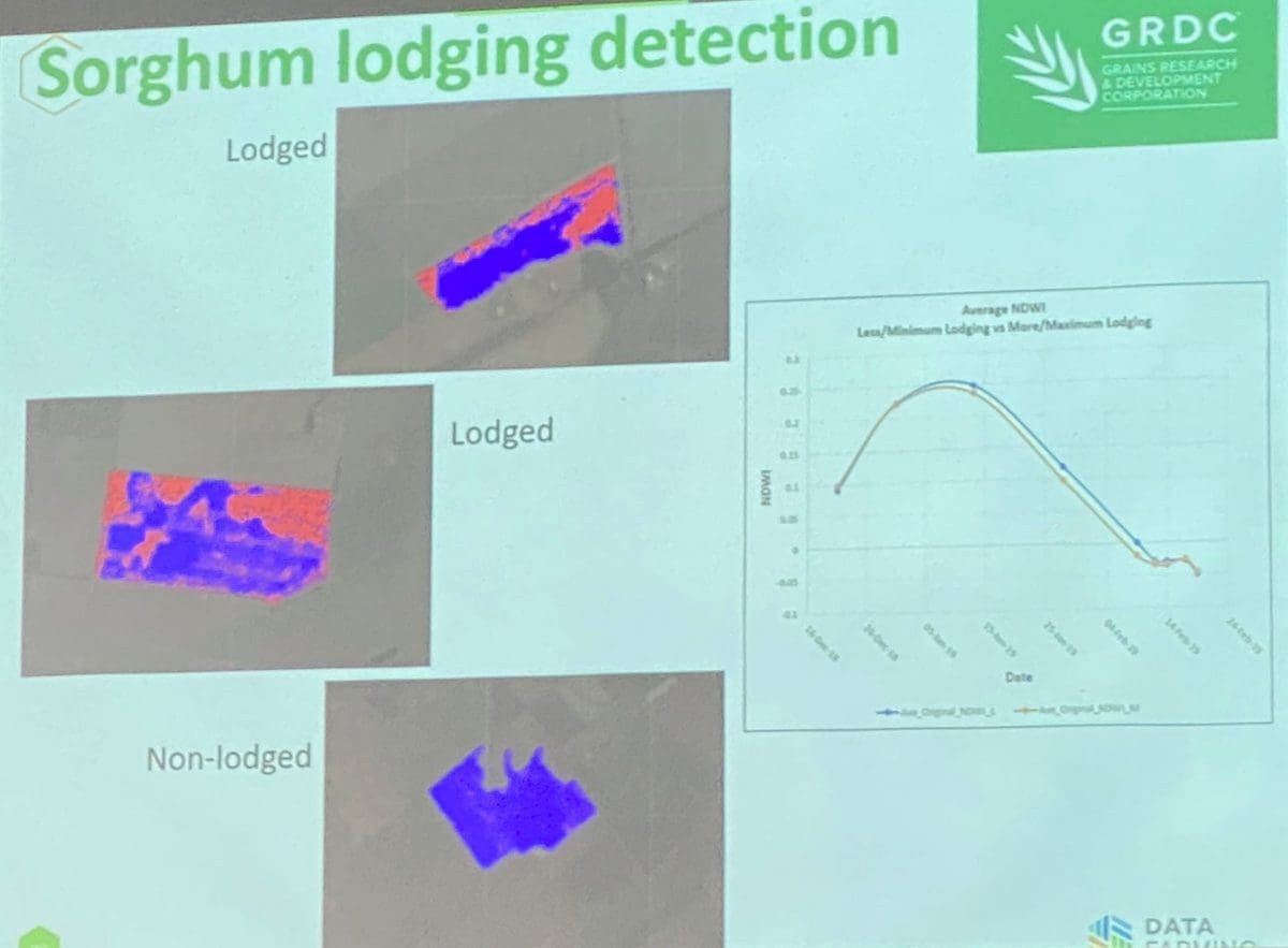
Figure 2: Red areas identify where the crop could potentially lodge.
Mr Neale said another useful application of satellite data was to stack it over multiple years.
“That gives you an indication of the longer-term performance issues, not just short term,” he said.
He said there were also some useful new, ground-based tools for rapid soil mapping.
Figure 3 below shows an electro-magnetic machine which measures electrical conductivity down to 1.5 metres into the soil profile.
“It is a really good tool for separating out those difference in subsoil constraints or differences in clay content. It is also very sensitive to moisture in clay soils. Many people have used it for soil water measurement as well,” he said.
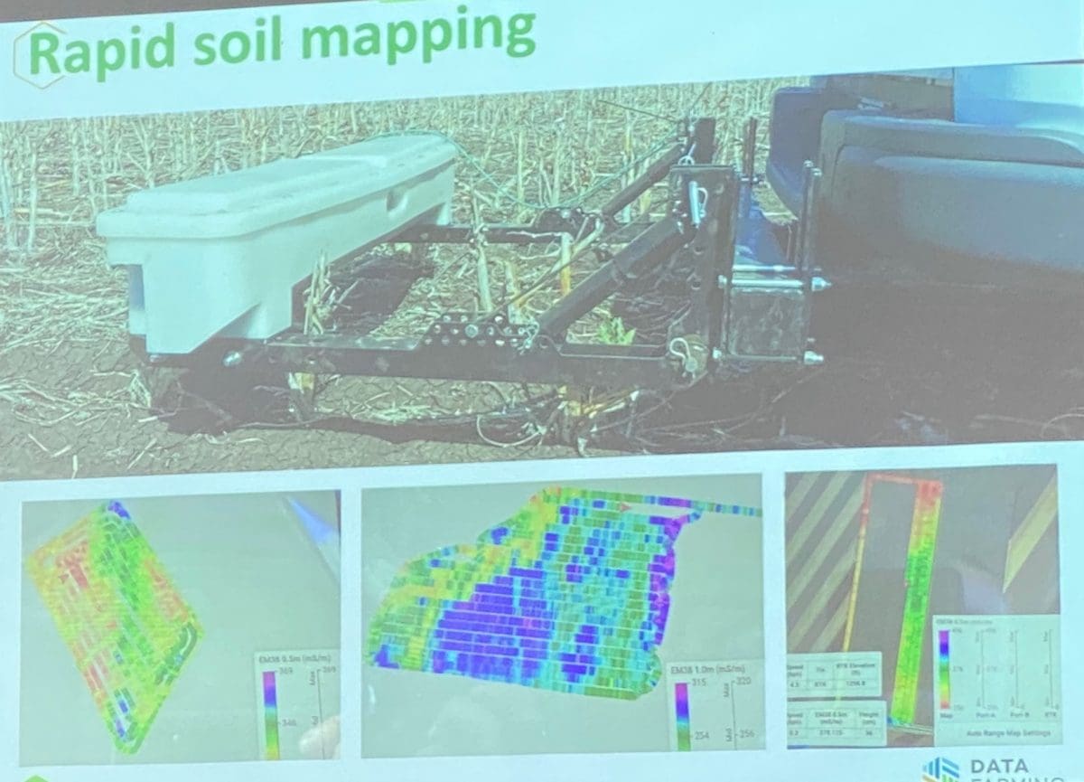
Figure 3: An electro-magnetic machine which measures electrical conductivity down to 1.5 metres into the soil profile.
Mr Neale said thermal imaging was another technology advancing in capacity and set to find greater application on farms where it could pick up water stress in crops.
“You can get thermal imaging now but it is at very coarse resolution. They are talking about getting thermal down to three-metre resolution which will be great for irrigation and crop stress,” he said.
Grain Central: Get our free cropping news straight to your inbox – Click here


HAVE YOUR SAY