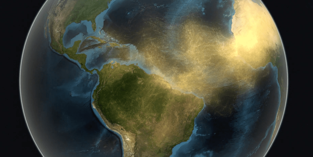
To better understand how plant pathogens that travel the globe with dust particles might put crops at risk, a Cornell University-led team of scientists will use data from NASA’s Earth Observing Satellites to identify areas of potential disease and track plumes of dust that traverse the globe.
At the end of June, the largest dust cloud ever observed by satellites crossed the Atlantic from the Sahara in North Africa to the Americas.
Undoubtedly, that cloud carried plant pathogens that hitched rides with dust particles.
A multidisciplinary, Cornell-led team of scientists has been selected for a $750,000 NASA grant to combine their expertise in remote sensing, climate and earth system computer modeling, plant pathology and genomics to better understand how plant pathogens that travel the globe with dust particles might put crops at risk, especially in places where people struggle to eat.
VIDEO: NASA remote sensing satellites will help Cornell University faculty Katie Gold, assistant professor of plant pathology, and Natalie Mahowald, professor of Earth and atmospheric sciences, study the effects of soilborne plant pathogens which can travel in dust clouds from Africa to the Western Hemisphere.
It’s well documented that plant pathogens in the soil become airborne; infectious spores have been found in dust samples that travel on intercontinental winds. The team will use Earth-observing satellites to identify areas of potential disease and track plumes of dust that traverse the globe. They will also use earth system modeling to predict how regions will change over time and how that may influence disease dispersal with dust.
NASA’s Release of Research Opportunities in Space and Earth Science Interdisciplinary Science grant is for three years, which will allow the team to lay the foundation for a global surveillance system to assess risk and track and potentially prevent the global spread of plant diseases.
If the origins and landing spots of specific pathogens can be better predicted, farmers can be advised on how to avoid practices that would increase its spread, such as those that kick up dust from farm fields, and perhaps grow less susceptible crops where such dust falls.
“We lose anywhere from 15pc to 30pc of the global harvest to plant diseases annually; here in 2020, people still die because they don’t have access to food, because of losses due to plant disease,” said principal investigator Katie Gold, assistant professor in the College of Agriculture and Life Sciences’ School of Integrative Plant Science, based in the Plant Pathology and Plant-Microbe Biology Section in Geneva, New York. “Remote sensing can do a lot help mitigate the impacts of plant disease on the global food supply.”
“It’s just a fascinating combination of cross-disciplinary work that’s going to allow us to address things that no one has been able to address before,” said co-investigator Natalie Mahowald, the Irving Porter Church Professor in Engineering in the Department of Earth and Atmospheric Sciences and an expert in atmospheric modeling.
Fusarium oxysporum (F. oxy), an economically important pathogen that causes fusarium wilt in more than 100 plant species, will serve as a model system for the study, to establish proof of concept. Endemic to six continents, F. oxy can survive in the soil for more than 20 years, causing farmers to abandon infected fields. This study’s framework for monitoring the risk of global plant disease could be applied to many other plant pathogens.
“Disease is the result of a susceptible host interacting with a virulent pathogen within a conducive environment,” Gold said.
In order to identify environments conducive for disease, the researchers will use data from multiple instruments on NASA’s Earth Observing Satellites that show vegetation patterns, combined with what is known about F. oxy and its epidemiology, to map and model in real time areas where crops are susceptible to fusarium wilt. A computer model can also reveal how areas conducive to fusarium wilt change as the Earth’s climate changes.
Next, the researchers will use other computer models that show global transport of dust plumes, which are informed by decades of meteorological and remote sensing aerosol data.
“We do these simulations over 40 years, so we can compare in detail what happened during one [aerosol transport] event versus another event, as well as what we call the climatology, which is what time of year and where these events are happening,” Mahowald said.
Simulations of dust transport will allow the team to link the origins and destinations of dust plumes with areas most conducive to fusarium wilt outbreaks and susceptible crops. “Using these known [fusarium wilt] incident sites, can we see if there’s [aerosol transport] modeling evidence to suggest that they’re potentially linked,” Gold said.
The team will then apply genomics to compare genomes of F. oxy samples from different sites to validate the modeling results. Such comparisons will help answer if samples from two distant sites of fusarium wilt outbreaks are genetically linked and whether those connections are backed up by the dust flow patterns that the aerial transport models reveal.
“That leads us to the final goal: integration,” Gold said. “Can we take these remote sensing data streams, the Earth system and aerosol transport modeling, and combine them with comparative genomics to develop a fully formed foundation of a global disease surveillance system?”
Other co-investigators include Ryan Pavlick, an imaging spectroscopy technologist at NASA’s Jet Propulsion Lab, and Sharifa Crandall, assistant professor of soilborne disease dynamics and management at Pennsylvania State University.


HAVE YOUR SAY