DRY spring conditions through the heart of the Western Australian wheatbelt have stripped about 1.5 million tonnes (Mt) from the state’s winter crop estimates in the past month as harvesters move through early wheat and lupin crops in the north east and early barley crops in the central and eastern areas.
Michael Lamond
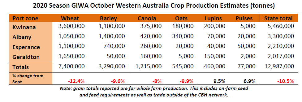
In its latest crop report released today, the Grain Industry Association of WA (GIWA) estimates the state will produce just under 13Mt of winter crop, down from the September estimate of 14.5Mt.
GIWA estimates production will be about 7.4Mt of wheat, 3.29Mt barley, 1.215Mt canola, 545,000t Oats, 460,000t lupins and 77,000t other pulses.
GIWA Oilseeds Council chair and crop report author, Michael Lamond, said the lack of spring rain had had a significant impact on crop yield potential, although it would not be quite as bad as some people had thought.
“The slide in potential grain yield has been substantial over the last month with even the high rainfall regions going backwards over the last few weeks,” he said.
“The coolish conditions in September have helped arrest some of the slide in yield although there simply has not been enough rain during the year or enough in the sub-soil for crops to perform without spring rain. In saying this, close inspection of cereal crops is indicating most will yield more than expected.”
Mr Lamond said barley had taken the biggest hit.
“A lot of the heads have just emerged out of the boot and are sticking upright. They are not going to yield and there will be screening problems. The barley that is hit the hardest is in the central region, not so much the south,” he said.
“The wheat area decline is due to a massive strip of country in the centre, a corridor about 1.2 million hectares north to south where the slide has been the greatest. That is made up for in the east where there are some areas that are very good, and in the west that are a bit better.”
Mr Lamond said it was too early to make a call on grain quality, although most were expecting high screenings in barley and less so in wheat.
“Cool spring conditions appeared to have allowed wheat crops to more preferentially fill the bottom half of heads due to the “slow” burn off, rather than a “quick” burn from heat where all grains in the heads tend to pinch up and give high screenings,” he said.
Mr Lamond said unusually for this time of year in the north around Geraldton there was still canola that hadn’t been desiccated.
“Lupin crops have grown exceptionally well and most will yield above average. Expectations are that canola crop quality will vary. Even though the majority of canola plantings are in the medium to high rainfall areas, it is only in the southern and south western regions where above average yields are expected,” he said.
The increase in oat plantings this year is not going to result in excess supply as was feared earlier in the season. More than planned was cut for hay to hit tonnage targets as yields were down and oats for grain are only expected to be average except for the south west coastal regions
Zone by zone
Geraldton Zone
Crops north of the Tenindewa line on the good sandplain are going to be average with small areas of the better managed country above average. The west coastal regions in a line from Mingenew to Three Springs is good although grain yield potential drops away dramatically west of Carnamah and Coorow across to Eneabba. The coolish finish has allowed crops to dig deep for moisture and finish better than expected. The Chapman valley has been in a sweet spot all year and there are some excellent wheat crops north and east of Geraldton.
Crops fall away in the eastern areas on the heaver soils and some in the south eastern portions of the zone are going to be very poor. Cereal screenings are likely to be a problem on these heaver soils in the region and particularly in the east and south eastern areas.
There has been some early deliveries of lupins and wheat, although canola and lupins on the deeper soils are still a way off and will need a blast of warm weather to finish them off before harvest. The Lupins and canola in particular have hung on very well and grain yields are going to be above average on the deep ripped country and wide rows. Some crops that needed re-sowing and were late sown due to early wind damage will be well below the better early established crops.
Wheat crops have handled the conditions well this year and grain quality is expected to be okay, with early deliveries holding up for screenings on the deeper soils. There is more wheat in the zone than previous years’, with less lupin, canola and barley area. The wheat, lupin and canola tonnage in this report is probably going to be at the bottom end of estimates and all three could exceed current estimates.
Kwinana Zone
Kwinana North Midlands
The region has had a very low decile year for rain and whilst this has helped the crops in the west from less leaching rains, the remainder of the zone except for some strips that received summer rain, the crops have survived on small “just in time” rainfall events all year. The cool finish has helped crops to fill and recent estimates of potential grain yield for most crops is pointing to them yielding more than they look from a glance.
Closer inspection of cereals to gain estimates for harvest is indicating that grain yields will be better than they look from the road. Whilst “nothing is going to go as good as it looked” earlier in the growing season the grain yield slide is not going to be as dramatic as feared form the complete lack of finishing rains.
The hay crops in the region yielded half to two thirds of a tonne more than expected and it looks like crops might do the same.
The wheat crops have lost up 30-40 per cent of potential sites for seed set, although what’s left is filling better than expected. The cool conditions have allowed crops to suck every drop of moisture out of the profile and put into grain. There is going to be big differences in variety yields as any that were setting potential earlier in the spring have “over-estimated” the season and tried to fill too many sites. These varieties have been unable to pull back on potential. It is expected the earlier maturing varieties will not yield as well and have higher screenings than the later varieties.
The reduced barley plantings in the region will yield slightly higher than wheat as is going to be the case over most of the grain belt rather than well above wheat which is usually the case in the central and southern regions of the state. Barley for malt is also expected to be down by to 30-40% of deliveries or about half of what will normally make malt grades.
Lupins are very good with some of the better crops likely to yield 1.5T/ha or more. Canola is very mixed depending on where you are in the zone. In the east and central regions the canola yields are going to be below average and the western areas generally above average.
Kwinana South
Harvest will get underway in the next week to ten days. Some areas of the zone had up to 10mm of rain in September and it is surprising what a difference that has made to the crops struggling for moisture. The cool temperatures recently have been a saving grace and has allowed the wheat in particular to finish a lot better than expected considering the growing season rainfall.
The majority of crops have hayed off prematurely with barley crops going white and the heads in a lot of cases not fully emerging from the boot. Wheat crops have gone a pastel grey/green colour with white tips over the last few weeks and in the western regions of the zone have lost a lot of potential yield. The poor north/south centre strip of the region that has been down on rainfall all year is going to be well down on average yields. An indication as to the severity of the finish is some of the first grain deliveries in the state are in this area, rather than the north-south progression in a normal year.
Even though there are good areas to the east and reasonable areas to the west, total tonnage for the zone is going to be significantly affected as the worst hit areas could be 50% down on average yields and this is in the more reliable rainfall zones historically.
On the bright side of things, lupin yields will be good as they will be across the state, reviling in the warm winter growing conditions.
Canola crops were hanging in there until recently and many have the top third of the podded area now very light on for grain fill. As often happens when canola yields look the be on the low end of expectations, growers tend to back off on input costs and this has been the case this year with many potential sub-one tonne crops not sprayed for late aphid infection. The yield loss from late aphid, diamond back moth or budworm infection can strip a third of the final potential yield off an already stressed canola crop as these beasts tend to “go to town” more so on stressed crops.
Kwinana North East
There will be areas in the Kwinana North East region that are going to be outstanding and others that will be terrible, it all comes back to the summer rain that fell. Areas that received the summer rain and resulting stored moisture are going to be well above average. Growers in a line from Kirwan bin to Koorda, Trayning, Nungarin, Merredin and down to Muntadgin will harvest above average crops. Due to large area and potential yield of some of these crops there is going more grain from this zone than there has been in the last few years.
On the down side of this is the cut off in potential yields is pretty dramatic south west of this line and north of the line that received the summer rain. The tail off east is quite dramatic as well east of Burracoppin where there has been less rainfall all year. The far eastern areas from Marvel Loch north to Southern Cross up to Bullfinch and west to Bonnie Rock are very poor and going to be well down on average yields.
The extra grain likely to come out of the better portions of region will to some degree make up for the well below expected grain yields in the central regions of the Kwinana zone.
Albany Zone
Albany West
Harvest looks to be on track to start at a similar time to last year. Crops have hayed off very quickly which will take some of the top end grain yield potential from the better crops. Most growers in the zone are expecting an above average year even with the lack of spring rain. There are a few poorer holes in the region around Darken and West Arthur, although for the most part the region will be above average for all grains.
These southern areas have not had the warm day further north and have been able to use every drop of rain that has fallen this year. As will be the case for most of the state, water use efficiencies (WUE) will be off the scale. In this region it will be mainly due to the lack of waterlogging and many crops getting away earlier than normal to utilise the full growing season.
Growers will start swathing canola next week and most barley crops are getting close to 30% moisture.
A late frost that has damaged crops further south seems to have done minimal damage in the region.
The bean crops in the region have again gone well and whilst most growers would admit they have not “nailed” growing beans just yet, the combination good soil type selection, higher yielding varieties with better disease tolerance and better understanding of their growing requirements, expect to see more gown in the region in the future.
Albany South
Crop outlook was improving in the region as the season progressed from the scratchy start until recently when a frost out of the blue has taken the top off many crops in the South Stirling’s region. The “freezing fog” as some have described it, has had a substantial impact on individual paddocks. Although the reduction in total grain production from the frost event is likely to be less than 5%.
The region had a very difficult start with patchy rain until a few decent winter fronts turned up in July. The variable emergence of crops is going to limit the top end grain yield potential as is the lack of substantial sub-soil moisture. Crops have been hanging onto the sub 5mm rainfall events all spring with the cool conditions allowing crops to make some use of these light rainfall events.
In general most crops could end up close to average rather than above average.
Albany East (Lakes Region)
The Lakes district will have a return to average yields for the most areas in the region this year except for some very poor areas south and east of Lake Grace and north east between Hyden and Lake Grace, particularly on the heavy country. The region has suffered through several poor years due to lack of rain and frost in recent times and whilst the good start will not be realized due to the season cutting out, most crops seemed to have set enough potential earlier in the growing season to reach average grain yields.
The cereals look like they will yield better than they look or what you would expect from the rain that has fallen. There are more tillers with more sites to fill than you would normally get in a dry finish. The contribution to yield from tillers is going to be significant due to the slow “cut off”. Normally these tillers would amount to very little and be left with fewer heads to carry the weight.
Lupins in the region look ok with some height for a change and canola expected to yield better than it has for the last three years. The yield range for lupins and canola will around 0.8T/ha to 1.0T/ha for most areas.
Esperance Zone
The Esperance Port Zone will be well up on last year’s deliveries of less than 2M tonnes. The contribution from the western areas from Lake King down to Ravensthorpe and a return to closer to average yields in the central portions of the zone will mean total production could be up by more than half a million tonnes.
The northern areas around Salmon Gums and north of Beaumont are going to be well below average due to a poor start and dry all year. The central Esperance zone had a very scratchy start although it has continued to improve with most areas receiving good falls of rain in August to even crops out. The coast has been dryer than normal and has suffered less from waterlogging than it usually does and this will keep average paddock yields up.
The western strip of the zone received the tail end of the summer storms and whist it has tightened up recently, crop grain yield potential is very good. Further south around Ravensthorpe, West River and south, closer to the coast, crops are generally going to be above average. There are some spots to the south west boarding on the West Albany zone that had a late start and whilst crops have picked up, grain yields will be below average.
Bugs have been a pain all year with Diamond Back Moth, Aphids and Budworm active the whole growing season.
Season Outlook, October 2020
WA Department of Primary Industries and Regional Development’s Ian Foster said seasonal rain since April had been below average for a region running from the Mid-West, through the central agricultural area and into the Lakes district.
September rain finished up below average for much of this region, with only the South West and western parts of the Great Southern receiving average rain.
The eastern South Coast received little rain.
October may also struggle to make average rain across most cropping areas.
Modelled soil water storage in early October (Figure 1) shows the results of seasonal rain and simulated crop water usage, with large parts of north-eastern, central and eastern agricultural areas sitting on small amounts of soil water.
This is an expansion of area since September. Seasonal temperatures to date have been 1 to 2 degrees C above average and are likely to have accelerated crop development.
Seasonal rainfall outlooks from the Bureau of Meteorology and international models are shifting to wetter rainfall probabilities for WA for November to January, compared with October to December. This is most likely the influence of the current La Nina event in the Pacific Ocean.
DPIRD’s statistical model has a drier than normal outlook for October and November 2020, based on September global climate.
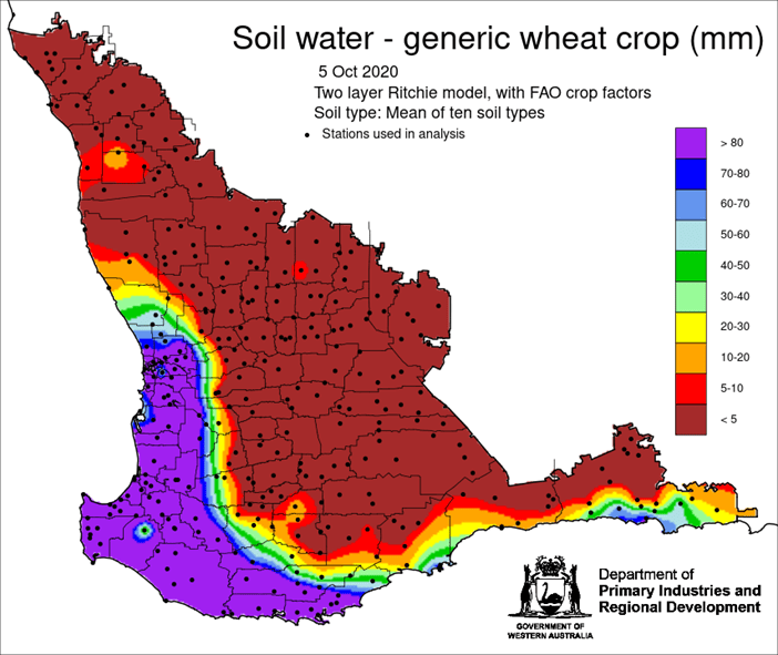
Figure 1: Estimated soil water storage for the average of 10 typical soil types and assuming a standardised crop water usage. This uses seasonal rainfall until 5 October 2020. From Department of Primary Industries and Regional Development.
Bureau of Meteorology seasonal outlook summary, issued 8 October 2020
- November to January is likely to see above average rainfall across nearly all of Australia, except west coast Tasmania.
- Days during November to January are likely to be warmer than average for parts of the northern and western coastal fringe, and across parts of south-east Australia.
- Nights during November to January are very likely to be warmer than average across nearly all of Australia.
- The Bureau’s ENSO Outlook is at La Niña, meaning La Niña is underway in the tropical Pacific.
- The Indian Ocean Dipole (IOD) index value is currently neutral, though models suggest negative values may return in October and persist in November.
- La Niña and a negative IOD typically increase the likelihood of above average rainfall across much of Australia during spring and early summer.
Source: GIWA
Grain Central: Get our free cropping news straight to your inbox – Click here


HAVE YOUR SAY