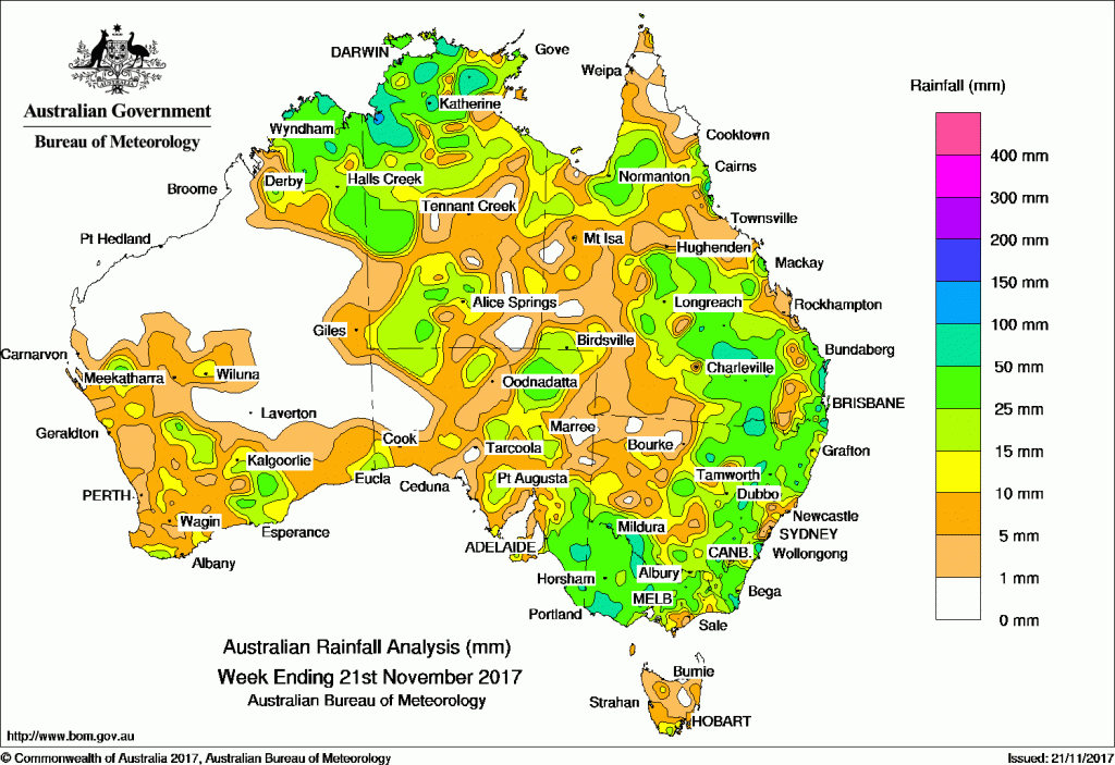
FOR the week to 21 November 2017, rainfall was recorded in all States and Territories, except in the Pilbara, northern Gascoyne and central interior districts of Western Australia.
At the beginning of the week, a large cloudband associated with a cold front and surface trough tracked across southeastern Australia. Thunderstorms and showers produced moderate to locally heavy falls in the eastern half of South Australia, western Victoria, southwestern New South Wales and parts of southern Tasmania. Broad areas of low pressure extended across the north and west of the continent, with showers and thunderstorms developing in the Top End and southern interior of the Northern Territory, the Kimberley, and along parts of the Gascoyne coast of Western Australia.
In the middle of the week, a low deepened over western Victoria, with the associated easterly trough becoming near stationary and extending north through western New South Wales and Queensland to a weak heat low in the Gulf Country. Moderate falls and thunderstorms were recorded in much of Victoria, while light to moderate falls were reported in the eastern half of New South Wales, and in Queensland’s southern and central interior. Thunderstorms and showers produced moderate falls across much of the southeastern quarter of Queensland and in northeastern New South Wales on the following days.
A series of low pressure troughs over northern and central Australia generated thunderstorms and showers, with moderate to locally heavy falls reported in the Kimberley, the west of the Northern Territory and the Top End, the Gulf Country, and Central Australia between the middle and end of the week. At the end of the week a broad area of low pressure developed over the northern interior of Queensland, while a very moist northeasterly airstream directed showers onto the north tropical coast of Queensland. Moderate to locally heavy falls were recorded across much of northern Queensland.
In the west, a cold front with an associated middle level cloudband and embedded thunderstorms tracked over southwest Western Australia during the middle of the week. Light to moderate falls were recorded in the South West Land Division and southern coast of Western Australia.
Rainfall totals exceeding 100 mm were recorded in a small area of the northwest Top End in the Northern Territory, at isolated locations in the east Kimberley District in Western Australia and pockets of the east coast of New South Wales, and north tropical Queensland Coast. The highest weekly total was 153 mm at both Nitmiluk Ridge in the Northern Territory and Bingil Bay in the north tropical coast of Queensland.
Rainfall totals between 50 mm and 100 mm were recorded in parts of the Kimberley District in the Northern Territory; across parts of the Top End in the Northern Territory; in the southern interior, coastal southeast and north tropical coast of Queensland; in pockets of eastern and southern New South Wales; in the far east, north and southwest of Victoria; and a small area of southeastern South Australia.
Rainfall totals between 10 mm and 50 mm were recorded in the South West Land Division, southern coast and Kimberley District of Western Australia; and in the northern half of the Northern Territory and much of the Alice Springs District. Similar totals were recorded across much of the eastern half and southern border districts of New South Wales; most of Victoria, southern Tasmania, most of the eastern half of South Australia, and most of Queensland except the far northern Cape York Peninsula and areas of western Queensland.
Little or no rainfall was recorded in remaining parts of Western Australia, much of western South Australia, much of northern and central Tasmania, and scattered areas across the country.
Source: BOM


HAVE YOUR SAY