Frost is a common visitor to southern and central Australia from late autumn to early spring. It can strike a chill, in more ways than one, in agricultural producers. So what is frost and when are we most likely to see it?
What is frost?
Frost is a deposit of soft white ice crystals or frozen dew drops on objects near the ground; formed when the surface temperature falls below freezing point.
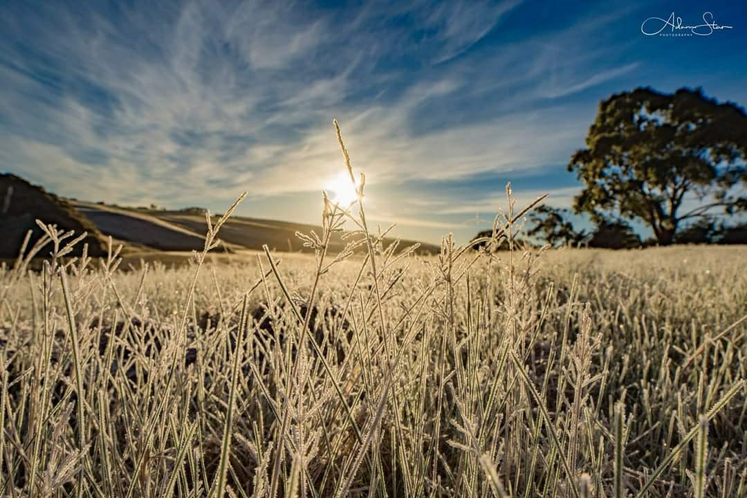
Frost at Pykes Creek Reservoir, Victoria, 1 July 2017. (Credit: Adam Stan Photography)
What conditions make frost likely?
If and where frost occurs is determined by a range of factors including temperature, cloud coverage, humidity, wind, the slope of the land, and geographic location.
For frost to form the temperature at ground level needs to be 0 °C or less. Our forecasts use an air temperature of below 4 °C as an indicator for frost, because the temperature at ground level will generally be much cooler than the air above it.
Frost is most likely to form under a clear sky, with low humidity and little or no wind, especially after the passage of a cold front. Why is this?
- Cloud cover—clouds act as a ‘blanket’ that helps prevent daytime warmth from escaping into space during the night. Clear skies mean the heat is free to escape, allowing for lower overnight temperatures.
- Wind—wind mixes the cooler air near the ground with warmer air just above it. This slows cooling at the ground.
- Humidity—when there is moisture in the air, and water changes from vapour to liquid, small amounts of (latent) heat are released. This heat slows the rate of cooling.
Where and when does frost occur?
Frost is most common in southern and central Australia. At low elevations on the mainland, it is generally confined to a period from late autumn to early spring. The frost season is much longer at higher elevations and in Tasmania. In alpine regions and higher parts of inland Tasmania frost can occur at any time of year.
Frost varies in severity across the landscape. Some areas, known as frost hollows, are particularly frost-prone. These are often in valleys where cold air moves down slopes, pooling in low-lying areas.
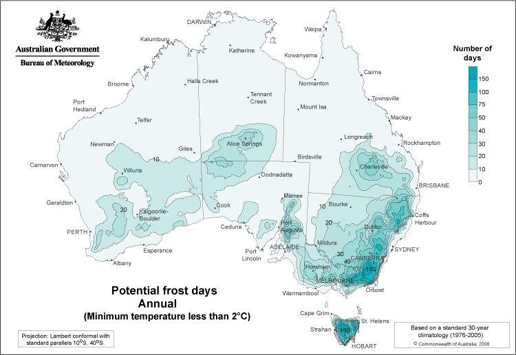
The potential frost days maps show areas that may be affected by frost. The map below shows the annual average number of days where the minimum air temperature falls below 2 °C. (However, note that this map is for frost frequency for the 30 years centred on the mid-1990s and we know that minimum air temperatures have increased over Australia since then.)
What is the impact of frost?
Frost can have a devastating effect on vegetation. Ice forms on the surface of plants and also freezes their internal cells. These ice crystals can expand and rupture delicate plant tissue.
The extent of damage depends upon frost severity—how quickly the temperature drops to 0 °C and the length of time it stays below it. Plant type, variety, sowing date, nutrition, and stage of growth can all determine the extent of damage from frost.
Frost damage costs Australian agriculture millions of dollars each year. A series of frosts in mid-to-late September 2016 affecting parts of southwest Western Australia caused devastating damage to crops, with losses of up to 90 per cent for some growers.
Frost can also pose a safety risk on the road, particularly at night and in dips or low-lying areas, where ice may form.
What frost forecasts and warnings are available?
Frost warnings, forecasts, and information about frost potential are available in a range of formats on our website.
| Product | What does it show? | For what period? |
| Frost warnings (Tasmania, Victoria, South Australia and Queensland only) | Warning about conditions likely to cause significant damage to frost-sensitive plants. | 12–24 hours ahead |
| Frost forecasts (MetEye) | Forecasts in map or text format which include information about frost when the right conditions occur and the forecast air temperature is below 4 °C. | Every 3-hour period over the next 7 days |
| Frost potential forecast | Map and table showing modelled duration of temperatures below 4 °C, 1 °C, –2 °C and –5 °C for weather station locations. |
Next 48 hours |
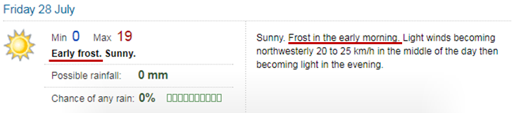
You will also see frost appear in text forecasts, available via our website and the BOM Weather app.
Watch for frost in the short-form forecast on the left-hand side and the longer-form forecast on the right. To allow people to plan ahead, we include frost on all seven days of the forecast. Since August 2017, we no longer use the frost icon as it’s generally not the most representative icon for the full day of weather.
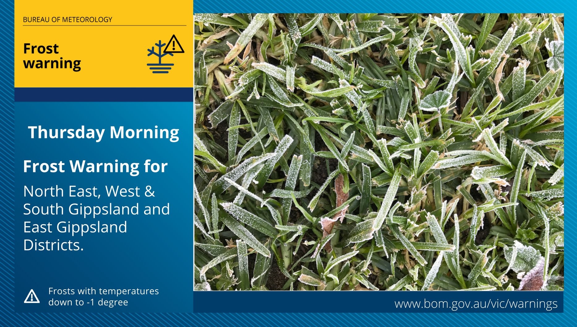
If you follow us on Twitter in Tasmania, Victoria, South Australia or Queensland you’ll see frost warnings like the one below in your feed.
Viewing frost forecasts in MetEye
The online tool MetEye has detailed forecasts showing where frost is possible at any specific location over three-hour intervals during the next seven days.
In MetEye, go to the section for forecasts of Storms, Snow, Rain, Fog and Frost, and select ‘Frost’.
Type in your location of interest in the box at the top of the map—South Tamworth in the example below—and select from the list. You can also type in longitude and latitude to see forecasts for remote properties or farms.
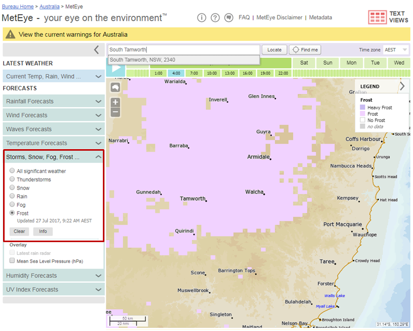
Image: MetEye frost forecast (map view)
A pop-up window with the seven-day forecast will also appear. Inside this window is a link to See text views for location which will take you to a detailed view.
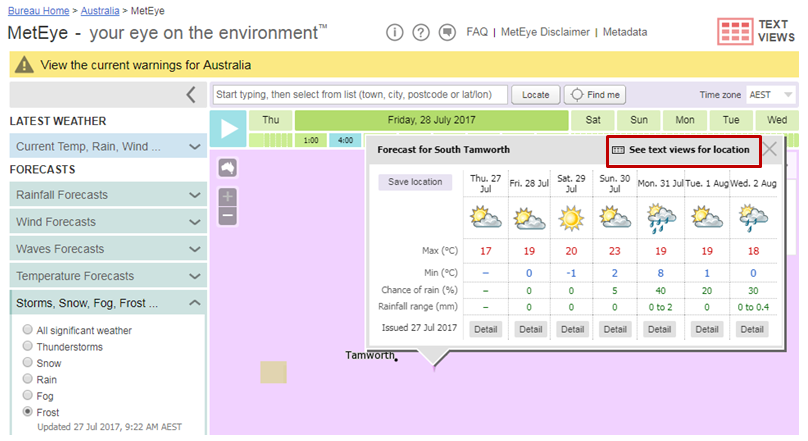
Image: MetEye frost forecast (pop-up window)
There’s a wealth of information in the MetEye text view. Click on ‘Detailed 3-Hourly forecast’ to see a 3-hourly breakdown for frost and other weather.
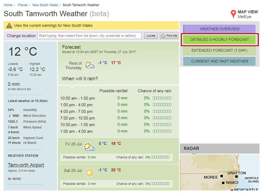
Image: MetEye frost forecast (text view)
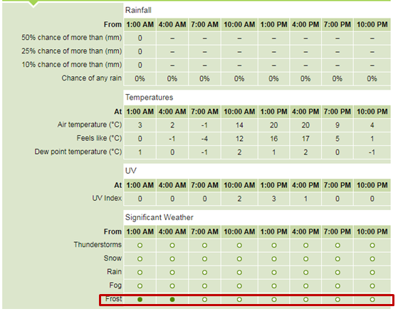
Image: MetEye (detailed 3-hourly forecast)
Source: Bureau of Meteorology, www.bom.gov.au


HAVE YOUR SAY