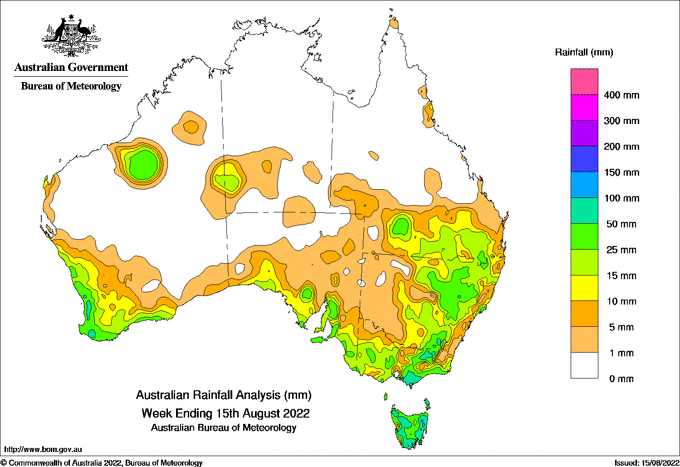
A SERIES of cold fronts crossed southern Australia during the week bringing moderate to heavy rain, strong winds, localised hail and some flooding in parts of Tasmania and Victoria.
A low in the Bass Strait at the end of the week led to weekly rainfall totals of 100-150 millimetres in western and eastern Tasmania, South Gippsland in Victoria, and pockets of north-eastern Victoria and the South West Slopes of New South Wales.
The highest weekly total at a Bureau gauge of 152.2mm was recorded at Mountain River, south of Hobart, including 125mm in the 24 hours to 9am August 14.
Major flooding was reported for the Moe River in Gippsland, and minor to moderate flooding for other rivers, mainly in north-east Victoria and north-east Tasmania.
The rain exacerbated some flood levels in inland New South Wales, with major flooding of the Macquarie River downstream of Warren Weir, and moderate flooding of the Murrumbidgee River at Narrandera.
Weekly rainfall totals of 50-100mm were recorded for much of Western Australia’s South West Land Division, with localised totals over 100mm, agricultural districts of south-east South Australia and the western slopes in NSW.
A cloudband crossed northern Australia from August 10-12, bringing totals of 10-50mm to remote areas of central Australia and in southern and western Queensland.


HAVE YOUR SAY