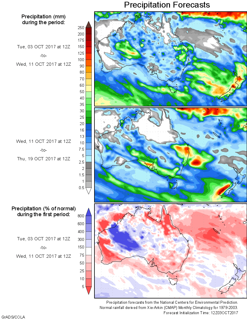
For today’s 14-day rainfall outlook – scroll to bottom of article
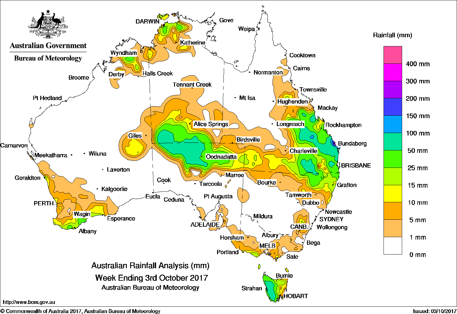
Late in the week, strong troughs combined to produce very heavy rain in the Wide Bay and Burnett districts in Queensland. Cold fronts brought moderate to heavy falls along Western Australia’s South Coast; also in western Tasmania.
Past seven days: At the start of the week, isolated thunderstorms from a broad, complex low pressure system delivered light to moderate falls along the South Coastal District of Western Australia, with light falls also around Perth and the West Coast; light rain fell along a trough extending from the system to the northwest. The system progressed eastward over the next day with isolated showers along the troughs and developing front, including heavier falls in the southwest of the Northern Territory, western Tasmania, and the New South Wales Tablelands.
Around mid-week a band of middle-level cloud became established over Central Australia, generated by a pair of strong surface troughs extending from the northwest of Western Australia through the Northern Territory and Central Australia to the southeast coast of Queensland and the New South Wales Central Coast. The resulting convective showers delivered moderate rainfall across a broad area of Central Australia, with lighter falls following in southern Queensland.
Meanwhile, Tasmania’s western coast received moderate to heavy rain due to a passing cold front behind the southern tail of the troughs, with some light falls in southern Victoria.
During the last few days of the week the strong surface troughs curved to follow the northern and western coastlines of Australia, spawning showers and thunderstorm activity over northeastern regions of the Northern Territory, where moderate to heavy rainfall was observed.
In Queensland, an easterly trough became established and persisted until the end of the week, resulting in widespread rain with isolated thunderstorm activity over Queensland’s southern and central interior and along the central and southern coasts. Moderate to heavy rain fell across eastern Queensland and northeastern New South Wales. Falls were especially heavy in the Wide Bay and Burnet District, where Bundaberg received 239 mm in the 24 hours to 9am on the 3rd with most of this total received in just a six hour period. The heavy rain caused some flooding across the region.
Totals in excess of 50 mm were observed in western Tasmania, Central Australia, and areas of Queensland in the Darling Downs and between the Central Highlands and Southeast districts. Locations around Bundaberg received more than 200 mm, including the highest weekly total of 276 mm at Woodgate Store.
Rainfall between 15 and 50 mm was recorded in areas surrounding higher falls, as well as in the Southern Coastal District of Western Australia, northeastern Tasmania, parts of the Kimberley and northwestern Northern Territory, and around the Otway Ranges in Victoria.
Rainfall totals between 5 and 15 mm were recorded surrounding areas of higher falls, across much of western Victoria and between South Gippsland and adjacent parts of the Northeast District, eastern Tasmania, a small area of Queensland between Townsville and Hughenden and parts of southern Queensland.
Little or no rainfall was recorded in much of Western Australia away from the Kimberley, South West Land Division and South Coast, the Northern Territory away from the south and northwest, South Australia away from the north, New South Wales away from the north and southeast, northern and western Queensland, and northwestern to central northern Victoria.
Highest weekly totals
New South Wales and Australian Capital Territory
76 mm Mullumbimby (Fairview Farm)
64 mm Byron Bay (Cape Byron Aws)
57 mm Ballina Airport Aws
Victoria
34 mm Cranbourne Botanic Gardens
28 mm Simpson South
25 mm Balook
Queensland
276 mm Woodgate Store
239 mm Bundaberg Aero
169 mm Mystery Park
Western Australia
39 mm Chillinup
34 mm Denmark
33 mm Warra Jarra, Geraldton Airport
South Australia
85 mm Todmorden
68 mm Tieyon
59 mm Mount Dare, Oodnadatta Airport
Tasmania
137 mm Mount Read
116 mm Lake Margaret Power Station
84 mm Queenstown (South Queenstown)
Northern Territory
61 mm Lambell’s Lagoon
52 mm Kangaroo Flats (Defence)
51 mm Shoal Bay
More weekly rainfall totals:
- NSW/ACT totals click here
- Vic totals click here
- Qld totals click here
- WA totals click here
- SA totals click here
- Tas totals click here
- NT totals click here
Source: BOM


HAVE YOUR SAY