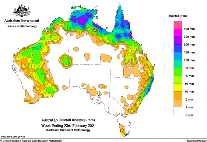
Past seven days: At the beginning of the week, a surface-to-low level pressure trough extended across northern Australia to the Coral Sea, with embedded weak tropical lows located in the western Gulf of Carpentaria, and off the north tropical coast of Queensland. Moderate falls were recorded in the far northern Kimberley, in the Top End and the Carpentaria coast in the Northern Territory, and northern Queensland.
A high pressure system in the southern Tasman Sea extended a ridge over southeast Australia, and resulted in moderate falls along the east coast between south-east Queensland and the Mid North Coast in New South Wales.
In the west, an inland trough stretched down to the south coast and produced light to moderate falls in the east Pilbara, and central Western Australia.
In the first part of the week, a weak cold front and a pre-frontal trough moved across southern Western Australia and produced light to moderate falls in the state’s far southwest, south coast and the Goldfields.
In the second part of the week, a trough off the east coast of Australia deepened and a low pressure system formed in the northern Tasman Sea, well off the northern New South Wales coast. Moderate falls to locally heavy falls were recorded in coastal south-east Queensland, and the northern to central coasts of New South Wales. The Tasman low moved slowly south to south-east away from Australia by the end of the week.
The trough over northern Australia persisted into the second half of the week, and the tropical low in the Gulf moved west to south-eastern Arnhem Land then across the base of the Top End in the Northern Territory. A weak tropical low formed off the Kimberley coast at the end of week. Showers and thunderstorms continued in the north streching from the Pilbara and Kimberley in Western Australia, through northern parts of the Northern Territory and Gulf country, across Cape York Peninsula to the north tropical coast in Queensland. Locally heaver falls in excess of 100 mm to 200 mm were recorded in the north tropical coast in Queensland, and the Carpentaria coast in the Northern Territory.
A high pressure system in the Great Australian Bight directed onshore flows, with light to moderate falls to in south-east Australia at the end of the week.
Rainfall totals in excess of 200 mm were reported in southern parts of the torth tropical coast in Queensland, the Carpentaria coast and along the base of the Top End in the Northern Territory. The highest weekly total was 709 mm at Tully Sugar Mill in Queensland.
Rainfall totals between 50 mm and 200 mm were reported over northern parts of the Northern Territory, across the Gulf country, Cape York Peninsula, northern Goldfields and North Tropical Coast in Queensland. Similar rainfall totals were also recorded in the Northern Rivers and Mid North Coast districts in New South Wales.
Rainfall totals between 10 mm and 50 mm were recorded in the Kimberley, Pilbara and south to the Goldfields and Southeast Coastal districts in Western Australia, across northern parts of the Northern Territory, northern, central and south-east Queensland, along the east of New South Wales, north-east Victoria and south-west Tasmania.
Highest weekly totals list and map
New South Wales and Australian Capital Territory
276 mm Port Maquarie (Port Macquarie
259 mm Port Macquarie Airport Aws (Co
250 mm Rosebank (Repentance Creek)
Victoria
39 mm Anglers Rest (Bundarrah Valley
17 mm Gelantipy
14 mm Ensay
Queensland
709 mm Tully Sugar Mill
412 mm Bingil Bay
387 mm Victoria Sugar Mill
Western Australia
148 mm Troughton Island
109 mm Truscott
72 mm Theda
South Australia
9 mm Port Broughton
8 mm Kadina Aws
7 mm Balaklava
Tasmania
18 mm Mount Read
17 mm Warra
16 mm Queenstown (South Queenstown)
Northern Territory
418 mm King Ash Bay
371 mm Centre Island
309 mm Nitmiluk Rangers
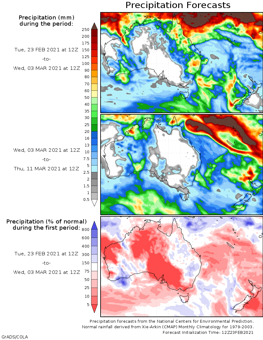
Rainfall outlook


HAVE YOUR SAY